Columbia Plateau Trail
| Columbia Plateau Trail State Park | |
| Washington State Park | |
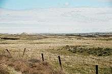
 The trail between the Martin Road and Amber Lake trailheads | |
| Country | United States |
|---|---|
| State | Washington |
| Counties | Adams, Franklin, Lincoln, Spokane, Whitman |
| Coordinates | 46°38′42″N 118°33′18″W / 46.64500°N 118.55500°WCoordinates: 46°38′42″N 118°33′18″W / 46.64500°N 118.55500°W |
| Length | 130 mi (209 km) |
| Area | 4,109 acres (1,663 ha) |
| Acquisition | 1991 |
| Management | Washington State Parks and Recreation Commission |
 Location of Kahlotus Trailhead
| |
| Website: Columbia Plateau Trail State Park | |
The Columbia Plateau Trail is a 130-mile-long (210 km), 20-foot-wide (6.1 m) corridor in eastern Washington state maintained as part of the Washington State Park system. The trail runs along the abandoned right-of-way of the former Spokane, Portland and Seattle Railway from Cheney to the confluence of the Snake and Columbia rivers at Pasco, Washington, passing through five counties in the southeastern part of the state. The trail's recreational uses include hiking, mountain biking, horseback riding, in-line skating on paved portions, and wildlife viewing.[1][2]
History
The rail bed was constructed by the Spokane, Portland, and Seattle Railway Company in the early 1900s. That line's successor, the Burlington Northern Company abandoned the line in 1987, paving the way for the state to acquire 130 miles of right-of-way, from milepost 235.0 near East Pasco to milepost 365.0 near South Cheney, in 1991. State Park management began in 1992.[2] Standing remnants of the trail's railroad past include the historic Burr Canyon trestle built in 1908.[1]
Natural features
- Wildlife
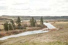
The northern portion of the trail passes through a habitat of primarily ponderosa pine/grassland mixed with exposed basalt cliffs and areas of meadow and shrub-steppe. It bisects the Turnbull National Wildlife Refuge, an area of northeastern Washington on the eastern edge of the Columbia River Basin which encompasses approximately 16,000 acres (6,500 ha) of the channeled scablands.[3] The numerous erosion-created potholes have formed over 130 marshes, wetlands and lakes which attract a wide range of waterfowl; more than 200 different kinds of birds have been recorded in this area. Other wildlife inhabiting the reserve include elk, mule deer, white-tailed deer, coyotes, badgers, porcupines, muskrats, and beavers.[4]
- Geology

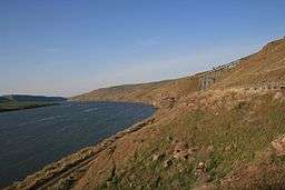
As it crosses the Columbia River Plateau, the trail passes through the unique geological erosion features of the channeled scablands created by the cataclysmic Missoula Floods that swept periodically across this portion of eastern Washington as well as other parts of the Columbia River Plateau during the Pleistocene epoch. The trail follows one of the many paths taken by the Missoula Floods as they cut through the Columbia River Basalt. Notable geologic features which the trail passes include the Cow Creek scabland, the point at which the Palouse River departs its former course (captured by ice-age flood erosion), Washtucna Coulee (the abandoned course of the Palouse River scoured wide by the floods), Devil’s Canyon (a dry, straight, 4-mile-long (6.4 km) former flood channel which descends to the Snake River), giant current-created ripples formed by the flood currents in the low lands along the Snake River, and the Walker Bar, created by the outflow of the floods.[5]
Access points
Proceeding from the northeast toward the southwest, major access points include:
- Fishlake trailhead – Milepost 365
- Cheney Trailhead – Milepost 361.25
- Amber Lake Trailhead – Milestone 349.25
- Martin Road Trailhead – Milestone 342
- Lamont Trailhead
- John Wayne Pioneer Trail intersection (no trailhead)
- Benge Trailhead
- Washtucna Trailhead (Trail Administrative Area in downtown Washtucna)
- Kahlotus Trailhead & Visitor Center 46°38′41.77″N 118°33′17.67″W / 46.6449361°N 118.5549083°W
- Snake River Junction Trailhead
- Ice Harbor Dam Trailhead 46°14′58″N 118°52′46″W / 46.24944°N 118.87944°W
- Sacajawea State Park Pasco
References
- 1 2 "Columbia Plateau Trail State Park". Washington State Parks and Recreation Commission. Retrieved January 20, 2016.
- 1 2 "Columbia Plateau Trail Management Plan". Washington State Parks and Recreation Commission. June 5, 2006. Retrieved January 20, 2016.
- ↑ "Turnbull National Wildlife Refuge Profile". U.S. Fish and Wildlife Service. Archived from the original on February 6, 2007. Retrieved February 10, 2015.
- ↑ "Turnbull National Wildlife Refuge". U.S. Fish and Wildlife Service. Retrieved February 10, 2015.
- ↑ Bjornstad, Bruce (2006). On the Trail of the Ice Age Floods: A Geological Guide to the Mid-Columbia Basin. Sand Point, Idaho: Keokee Books. ISBN 978-1-879628-27-4.
External links
| Wikimedia Commons has media related to Columbia Plateau Trail. |
- Columbia Plateau Trail State Park Washington State Parks and Recreation Commission
- Columbia Plateau Trail State Park North Map Washington State Parks and Recreation Commission
- Columbia Plateau Trail State Park South Map Washington State Parks and Recreation Commission
| King |
|  |
|---|---|---|
| Klickitat | ||
| Pierce | ||
| Snohomish | ||
| Thurston | ||
| Whatcom |
| |
| Multiple counties |
| |