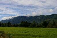
Rattlesnake Ridge
| Rattlesnake Mountain | |
|---|---|
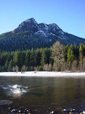 Rattlesnake Ledge with Rattlesnake Lake in the foreground | |
| Highest point | |
| Elevation | 3,480+ feet (1,061+ m)[1] |
| Prominence | 2,520 ft (770 m) [1] |
| Coordinates | 47°27′30″N 121°48′22″W / 47.4584358°N 121.8062219°WCoordinates: 47°27′30″N 121°48′22″W / 47.4584358°N 121.8062219°W [2] |
| Geography | |
| Location | King County, Washington State, U.S. |
| Parent range | Issaquah Alps, Cascades |
| Topo map | USGS North Bend |
| Climbing | |
| Easiest route | Hike |
Rattlesnake Ridge (sometimes called Rattlesnake Ledge or Rattlesnake Mountain) is a mountain ridge located south of North Bend, Washington, United States. The western end is near the intersection of State Route 18 and I-90 in Snoqualmie, Washington and runs southeast about 7 miles (11 km) or 11 miles (18 km) by trail. It is the highest and easternmost of the Issaquah Alps (although Cedar Butte in the gap between Rattlesnake Ledge and the Cascade front at Mount Washington is considered by Harvey Manning to be a quasi-Alp). A complicated maze of abandoned logging roads and constructed trails have been strung together to provide a 10.5-mile (16.9 km) foot path from the Snoqualmie Point Trailhead at Exit 27 on I-90 all the way to the Rattlesnake Lake trailhead near Exit 32.
Legal status
Most of the mountain is owned by the state of Washington or King County, and is protected as Rattlesnake Mountain Scenic Area, managed jointly by Washington State Department of Natural Resources and King County Park and Recreation Department. The Southern section of the mountain, closed to the public, is owned by Seattle Water Department, while large sections in the western part of the ridge are owned by Weyerhaeuser Corporation, which conducts substantial logging operations there.[3]
Deaths
On May 30, 2009, a 28-year-old man fell one hundred feet to his death from a ledge on Rattlesnake Ridge. Officials say Ruben Maldonado, 28, of Snohomish County, fell from the popular hiking area above Rattlesnake Lake around 12:15 p.m.[4] [5]
On March 9, 2012, a 32-year-old man fell about 300 feet from a ridge. He was found dead by another hiker who saw the fall.[6][7]
On February 9, 2013, a Redmond man missing near Rattlesnake Ridge was found dead at about 10 a.m. Bove said King County Search and Rescue found the body of Ira Thomas Clodfelter, 28, about three-quarters of a mile from the main trail, and it appeared to be a suicide. The King County Medical Examiner said Feb. 11 that Clodfelter died from a gunshot wound to the head, and ruled it a suicide. [8]
On August 29, 2013, a man in his 20's fell to his death while hiking in the Rattlesnake Ridge area of Snoqualmie near Rattlesnake Lake. King County Sheriffs deputies received a 911 call around 10:55 a.m. from a woman who said someone had fallen off Rattlesnake Ridge. When rescue personnel arrived, a friend of the victim told them she and the man had hiked to the top of the ridge. She was taking pictures of the man, who was near the ledge, when he slipped and fell as he was trying to jump to a rock. Medics found the man's body and determined he had fallen about 150 feet to his death. [9]
References
- 1 2 "Rattlesnake Mountain, Washington". Peakbagger.com. Retrieved 2009-01-16.
- ↑ "Rattlesnake Mountain". Geographic Names Information System. United States Geological Survey. Retrieved 2009-01-16.
- ↑ SeattlePI.com: A lookout of legendary proportions at the Wayback Machine (archived December 10, 2007)
- ↑ Associated Press (May 30, 2009). "Hiker dies in fall from Rattlesnake Ledge". The Seattle Times.
- ↑ http://seattletimes.com/html/localnews/2009289938_webhiker02m.html
- ↑ Associated Press (March March 9, 2012). "Hiker falls to death near North Bend, Wash.". The Seattle Times. Check date values in:
|date=(help) - ↑ "Man dies in hiking accident Friday at Rattlesnake Ledge". Snoqualmie Valley Record. March 11, 2012.
- ↑ http://snovalleystar.com/2013/02/13/missing-redmond-man-shot-himself-at-rattlesnake-ridge
- ↑ http://blogs.seattletimes.com/today/2013/08/hiker-falls-to-death-near-rattlesnake-lake/
- "Rattlesnake Ridge". Central Cascades Hikes. GoNorthwest.com. Retrieved 2009-01-16.
- Sykes, Karen (2004-03-11). "Once rough route is kinder and gentler". Hike Of The Week. Seattle Post-Intelligencer. Retrieved 2009-01-16.
| Wikimedia Commons has media related to Rattlesnake Mountain Scenic Area. |
 Rattlesnake Ridge |
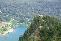 As viewed from above |