Colcha "K" Municipality
| Colcha "K" Municipality | |
|---|---|
| Municipality | |
|
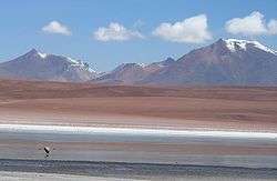
Lake Kara in Colcha "K" Municipality | |
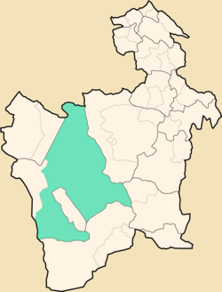 Location within Potosí Department | |
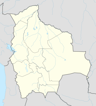 Colcha "K" Municipality Location within Bolivia | |
| Coordinates: 20°57′S 67°17′W / 20.950°S 67.283°WCoordinates: 20°57′S 67°17′W / 20.950°S 67.283°W | |
| Country |
|
| Department | Potosí Department |
| Province | Nor Lípez Province |
| Seat | Colcha "K" |
| Elevation | 12,500 ft (3,800 m) |
| Population (2001) | |
| • Total | 9,645 |
| • Ethnicities | Quechua |
| Time zone | -4 (UTC-4) |
Colcha "K" Municipality is the first municipal section of the Nor Lípez Province in the Potosí Department in Bolivia. Its seat is Colcha "K" or Villa Martín.
Geography
The municipality lies at the Uyuni salt flat.
Some of the highest mountains of the municipality are listed below:[1][2][3][4][5]
- Allqa Urqu
- Apachita
- Chakra Urqu
- Chinchillani
- Chiwana
- Chullunkhäni
- Chumpi Urqu
- Inti Pastu
- Kachi Unu
- Kuntur Wasi
- Muru
- Puka Urqu
- Puka Wasi
- Qala Wasi
- Qaral
- Siwinqani
- Suni K'ira
- Tijtin
- Yana Urqu
- Yanantillayuq
Subdivision
The municipality consists of the following cantons:[6]
- Atulcha Canton - 102 inhabitants (2001)
- Chuvica Canton - 53 inhabitants
- Calcha "K" Canton - 617 inhabitants
- Cocani Canton - 1.982 inhabitants
- Colcha "K" Canton - 1.229 inhabitants
- Julaca Canton - 61 inhabitants
- Llavica Canton - 274 inhabitants
- Río Grande Canton - 777 inhabitants
- San Cristóbal Canton - 1.980 inhabitants
- San Juan Canton - 981 inhabitants
- Santiago Canton - 509 inhabitants
- Santiago de Agencha Canton - 258 inhabitants
- Soniquera Canton - 822 inhabitants
The people
The people are predominantly indigenous citizens of Quechua descent.[7]
| Ethnic group | % |
|---|---|
| Quechua | 88.3 |
| Aymara | 5.6 |
| Guaraní, Chiquitos, Moxos | 0.1 |
| Not indigenous | 6.0 |
| Other indigenous groups | 0.1 |
See also
References
- ↑ "Colcha "K"". Archived from the original on October 14, 2014. Retrieved October 16, 2015.
- ↑ Bolivian IGM map 1:50,000 Chiguana 6030-IV
- ↑ Bolivian IGM map 1:50,000 Estancia Chilala 6031-IV
- ↑ Bolivian IGM map 1:50,000 Villa Martín 6031-I
- ↑ "South America Maps". Joint Operations Graphic. Retrieved October 16, 2015.
- ↑ National Institute of Statistics of Bolivia Archived September 24, 2011, at the Wayback Machine.
- ↑ obd.descentralizacion.gov.bo/municipal/fichas/ (inactive)
Capital: Potosí | ||
| Provinces |  | |
| Municipalities (and seats) |
| |
This article is issued from Wikipedia - version of the 11/27/2016. The text is available under the Creative Commons Attribution/Share Alike but additional terms may apply for the media files.