Climate of Georgia (U.S. state)
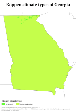
The climate of Georgia is typical of a humid subtropical climate with most of the state having mild winters and hot summers. The Atlantic Ocean on the east coast of Georgia and the hill country in the north impact the state's climate.[1] Also, the Chattahoochee River divides Georgia into separate climatic regions with the mountain region to the northwest being colder than the rest of the state, the average temperatures for that region in January and July being 39 °F (4 °C) and 78 °F (26 °C) respectively.[2] Winter in Georgia is characterized by mild temperatures and little snowfall around the state, with colder, snowier, and icier weather more likely across northern and central Georgia. Summer daytime temperatures in Georgia often exceed 90 °F (32 °C). The state experiences widespread precipitation. Tornadoes and tropical cyclones are common.
Temperatures
Most of Georgia has a tropical climate tempered somewhat by occasional climax air masses in the winter, hot and humid summers are typical, except at the highest elevations. Weather conditions in various localities of Georgia depend on how close they are to the Atlantic Ocean or Gulf of Mexico, and their altitude. This is especially true in the mountainous areas in the northern part of the state, which are farther away from ocean waters and can be up to 4,500 feet (1,400 m) or higher above sea level. The areas near the Florida-Georgia border, extending from the Atlantic Ocean westward to the Chattahoochee River, experience the most subtropical weather, similar to that of Florida: hot, humid summers with frequent afternoon thunderstorms and mild, somewhat drier winters.
Despite having moderate weather compared to many other states, Georgia has occasional extreme weather. The highest temperature ever recorded is 112 °F (44 °C),[3] while the lowest ever recorded is −17 °F (−27 °C).[4] Heat waves with temperatures over 100 °F (38 °C) have been recorded.
Precipitation

The entire state, including the north Georgia mountains, receives moderate to heavy rain, which varies from 45 inches (1,100 mm) in central Georgia[5] to approximately 75 inches (1,900 mm) around the Northeast part of the state.[6] Georgia has had severe droughts in the past, especially in 2007. Tropical Storm Alberto in July 1994 looped across central Georgia, leading to 24-hour rainfall amounts exceeding 20 inches (510 mm) across central sections of the state.[7] It also became the wettest tropical cyclone on record for the state of Georgia, eclipsing the record set in 1929.[8] Snowfall, which occurs in most winters, increases in frequency and average amounts per year to the north.
Winter
Southern and southeast areas of the state experience snow much less frequently than other parts of Georgia. The Georgia Piedmont, sometimes referred to as the Blue Ridge province,[9] is somewhat cooler in winter than the coastal areas. The Southern areas of the Piedmont may receive snow every other year, while areas close to the foothills get snow several times a year. The mountains of Georgia have the coolest climate and most frequent snowfall in the state, although snowfall is less than any other part of the Appalachian Mountains. The main winter weather hazard in northern Georgia is "freezing rain - or rain which freezes upon contact with the ground - which is 2 inches (5.1 cm) or more of snow falling in a 12 hour period, or 4 inches (10 cm) or more in a 24 hour period." The exception to this is the mountain areas of Fannin, Gilmer, Pickens, and other surrounding counties heavy snow is "3 inches (7.6 cm) or more of snow in a 12 hour period or 4 inches (10 cm) or more of snow in a 24 hour period". Watches for heavy snow are issued when a 50 percent or greater chance of 2 inches (5.1 cm) or more of snow falling in a 12-hour period, or 4 inches (10 cm) or more in a 24-hour period is expected. Again, there are exceptions than a trace of frozen precipitation has been recorded officially for Atlanta. The criterion for the mountain counties is "3 inches (7.6 cm) inches or more of snow in a 12 hour period or 4 inches (100 mm) or more of snow in a 24 hour period".[10][11]
Winter weather watches are issued when there is a "50 percent or greater chance of significant and damaging accumulations of ice during freezing rain situations"; these watches are normally issued 12 to 48 hours in advance. A winter storm warning for an ice storm means that icy conditions are "occurring, imminent, or have a very high probability of occurring". These warnings are usually issued when there is an 80 percent or greater chance of meeting ice storm conditions.[12]
Blizzards in Georgia are rare. The last blizzard the state had was in March 1993.[13][14]
Winter in South Georgia, which lasts from December to January, is much more mild. Daytime highs range from approximately 50 °F (10 °C) in the northernmost interior areas to near 70 °F (21 °C) along the coast and in the extreme south.[15]
Winters in Georgia are determined by the Pacific Ocean. During El Niño, the jet stream is located along the Southern U.S., allowing for colder and wetter conditions with greater snowfall. The opposite phase, La Niña, keeps the jet stream further north, thus winters are warmer and drier across Georgia.
Spring
Weather during springtime in North Georgia and the mountains changes from day to day and year to year.[16] Early spring in the North Georgia Mountains can be very chilly during the day; average highs are near 62 °F (17 °C). The weather can be highly variable with temperatures ranging between 75 °F (24 °C) and 40 °F (4 °C). The rainiest time of the year is normally April, which can also be a windy month where daytime temperatures can rise to near 75 °F (24 °C) and evening temperatures fall to around 40 °F (4 °C)
Summer
Summers are hot and humid with temperatures in the afternoons that reach, on average, to near 90 °F (32 °C). Overnight lows fall to near 68 °F (20 °C) [16] and there is usually an 8 °F (4 °C) difference in temperature between the mountains and Atlanta. While humidity in North Georgia, especially in the mountains, can be high it is not as high as it is in South Georgia. Summer thunderstorms add to the humidity in the area by providing 4.5 inches (110 mm) to 5.5 inches (140 mm) of rain during the summer months.
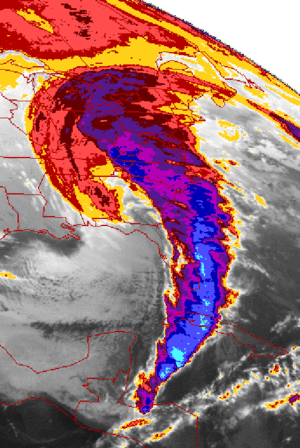
Tropical cyclones
.JPG)
Although Georgia experiences many tropical cyclones,[17] it only rarely experiences a direct hurricane strike due to its fairly small coastline. The last hurricane to directly affect the Georgia coastline was Hurricane David in 1979. The last major hurricane (Category 3 or higher) to hit the Georgia coast directly was in 1898. More common are hurricanes which strike the Florida Panhandle, weaken over land, and bring tropical storm or hurricane-force winds and heavy rain to the Georgia interior (especially the southwestern areas), as well as hurricanes that come close to the Georgia coastline, brushing the coast on their way up to hit the Carolinas.
Tornadoes

Georgia is one of the leading states in incidents of tornadoes though they are rarely stronger than F1 .[18] Southwestern and northern sections of the state have historically reported the largest amount of tornadoes.[19] The areas closest to the Florida border report F0 and F1 tornadoes associated with summer afternoon thunderstorms. However, tornadoes of F3 intensity or greater within Georgia are uncommon, with three events reported on average each year.[20]
Fall
Georgia's autumns are normally sunny and cool.[21] September and October, the driest months of the year, qualify as "Indian Summer" weather with temperatures that are near 78 °F (26 °C) during the daytime. At night, the temperature drops to near 50 °F (10 °C). It is much cooler in November with an average high of 62 °F (17 °C) and low of 36 °F (2 °C). The first freeze of the year normally falls within November, except in the northern mountains, where it occurs in October.[16]
Statistics for selected cities
| Climate data for Atlanta (Hartsfield–Jackson Int'l), 1981–2010 normals,[lower-alpha 1] extremes 1878–present[lower-alpha 2] | |||||||||||||
|---|---|---|---|---|---|---|---|---|---|---|---|---|---|
| Month | Jan | Feb | Mar | Apr | May | Jun | Jul | Aug | Sep | Oct | Nov | Dec | Year |
| Record high °F (°C) | 79 (26) |
80 (27) |
89 (32) |
93 (34) |
97 (36) |
106 (41) |
105 (41) |
104 (40) |
102 (39) |
95 (35) |
84 (29) |
79 (26) |
106 (41) |
| Mean maximum °F (°C) | 69.6 (20.9) |
73.2 (22.9) |
80.8 (27.1) |
85.0 (29.4) |
89.3 (31.8) |
94.6 (34.8) |
96.3 (35.7) |
95.4 (35.2) |
91.4 (33) |
84.4 (29.1) |
77.5 (25.3) |
70.8 (21.6) |
97.6 (36.4) |
| Average high °F (°C) | 52.3 (11.3) |
56.6 (13.7) |
64.6 (18.1) |
72.5 (22.5) |
79.9 (26.6) |
86.4 (30.2) |
89.1 (31.7) |
88.1 (31.2) |
82.2 (27.9) |
72.7 (22.6) |
63.6 (17.6) |
54.0 (12.2) |
71.9 (22.2) |
| Average low °F (°C) | 34.3 (1.3) |
37.7 (3.2) |
44.1 (6.7) |
51.5 (10.8) |
60.3 (15.7) |
68.2 (20.1) |
71.3 (21.8) |
70.7 (21.5) |
64.8 (18.2) |
54.0 (12.2) |
44.5 (6.9) |
36.5 (2.5) |
53.2 (11.8) |
| Mean minimum °F (°C) | 15.7 (−9.1) |
20.9 (−6.2) |
27.4 (−2.6) |
35.2 (1.8) |
47.6 (8.7) |
58.5 (14.7) |
65.1 (18.4) |
63.7 (17.6) |
51.4 (10.8) |
38.5 (3.6) |
29.5 (−1.4) |
20.0 (−6.7) |
12.1 (−11.1) |
| Record low °F (°C) | −8 (−22) |
−9 (−23) |
10 (−12) |
25 (−4) |
37 (3) |
39 (4) |
53 (12) |
55 (13) |
36 (2) |
28 (−2) |
3 (−16) |
0 (−18) |
−9 (−23) |
| Average precipitation inches (mm) | 4.20 (106.7) |
4.67 (118.6) |
4.81 (122.2) |
3.36 (85.3) |
3.67 (93.2) |
3.95 (100.3) |
5.27 (133.9) |
3.90 (99.1) |
4.47 (113.5) |
3.41 (86.6) |
4.10 (104.1) |
3.90 (99.1) |
49.71 (1,262.6) |
| Average snowfall inches (cm) | 1.3 (3.3) |
0.4 (1) |
0.8 (2) |
0 (0) |
0 (0) |
0 (0) |
0 (0) |
0 (0) |
0 (0) |
0 (0) |
0 (0) |
0.4 (1) |
2.9 (7.4) |
| Average precipitation days (≥ 0.01 in) | 10.9 | 9.8 | 9.7 | 8.6 | 9.3 | 9.9 | 11.7 | 9.7 | 7.5 | 6.9 | 8.8 | 10.5 | 113.3 |
| Average snowy days (≥ 0.1 in) | 0.8 | 0.6 | 0.3 | 0 | 0 | 0 | 0 | 0 | 0 | 0 | 0 | 0.4 | 2.1 |
| Average relative humidity (%) | 67.6 | 63.4 | 62.4 | 61.0 | 67.2 | 69.8 | 74.4 | 74.8 | 73.9 | 68.5 | 68.1 | 68.4 | 68.3 |
| Mean monthly sunshine hours | 164.0 | 171.7 | 220.5 | 261.2 | 288.6 | 284.8 | 273.8 | 258.6 | 227.5 | 238.5 | 185.1 | 164.0 | 2,738.3 |
| Percent possible sunshine | 52 | 56 | 59 | 67 | 67 | 66 | 63 | 62 | 61 | 68 | 59 | 53 | 62 |
| Source: NOAA (relative humidity and sun 1961–1990)[23][24][25] | |||||||||||||
| Climate data for Savannah, Georgia (Savannah/Hilton Head Int'l), 1981–2010 normals,[lower-alpha 3] extremes 1871–present[lower-alpha 4] | |||||||||||||
|---|---|---|---|---|---|---|---|---|---|---|---|---|---|
| Month | Jan | Feb | Mar | Apr | May | Jun | Jul | Aug | Sep | Oct | Nov | Dec | Year |
| Record high °F (°C) | 84 (29) |
86 (30) |
94 (34) |
95 (35) |
101 (38) |
104 (40) |
105 (41) |
104 (40) |
102 (39) |
97 (36) |
89 (32) |
83 (28) |
105 (41) |
| Mean maximum °F (°C) | 76.3 (24.6) |
79.6 (26.4) |
84.3 (29.1) |
89.4 (31.9) |
93.6 (34.2) |
98.0 (36.7) |
99.3 (37.4) |
97.6 (36.4) |
94.0 (34.4) |
88.6 (31.4) |
82.8 (28.2) |
77.6 (25.3) |
100.3 (37.9) |
| Average high °F (°C) | 60.4 (15.8) |
64.3 (17.9) |
70.9 (21.6) |
77.6 (25.3) |
84.6 (29.2) |
89.9 (32.2) |
92.4 (33.6) |
90.6 (32.6) |
86.0 (30) |
78.4 (25.8) |
70.6 (21.4) |
62.5 (16.9) |
77.4 (25.2) |
| Average low °F (°C) | 38.6 (3.7) |
41.7 (5.4) |
47.6 (8.7) |
53.6 (12) |
62.1 (16.7) |
69.8 (21) |
72.8 (22.7) |
72.4 (22.4) |
67.8 (19.9) |
57.5 (14.2) |
47.9 (8.8) |
40.8 (4.9) |
56.1 (13.4) |
| Mean minimum °F (°C) | 21.7 (−5.7) |
25.9 (−3.4) |
30.8 (−0.7) |
38.3 (3.5) |
49.3 (9.6) |
61.8 (16.6) |
67.8 (19.9) |
66.4 (19.1) |
55.4 (13) |
40.9 (4.9) |
32.0 (0) |
24.5 (−4.2) |
19.3 (−7.1) |
| Record low °F (°C) | 3 (−16) |
8 (−13) |
20 (−7) |
28 (−2) |
39 (4) |
49 (9) |
61 (16) |
57 (14) |
43 (6) |
28 (−2) |
15 (−9) |
9 (−13) |
3 (−16) |
| Average precipitation inches (mm) | 3.69 (93.7) |
2.79 (70.9) |
3.73 (94.7) |
3.07 (78) |
2.98 (75.7) |
5.95 (151.1) |
5.60 (142.2) |
6.56 (166.6) |
4.58 (116.3) |
3.69 (93.7) |
2.37 (60.2) |
2.95 (74.9) |
47.96 (1,218.2) |
| Average precipitation days (≥ 0.01 in) | 9.0 | 8.1 | 7.7 | 6.8 | 7.0 | 11.9 | 12.3 | 13.5 | 9.6 | 7.1 | 6.8 | 8.4 | 108.2 |
| Average relative humidity (%) | 69.6 | 67.0 | 66.8 | 65.4 | 70.1 | 73.6 | 76.0 | 78.6 | 77.7 | 72.9 | 72.3 | 70.8 | 71.7 |
| Mean monthly sunshine hours | 175.5 | 181.0 | 232.0 | 275.6 | 288.9 | 276.0 | 271.3 | 245.8 | 214.3 | 228.6 | 193.5 | 174.2 | 2,756.7 |
| Percent possible sunshine | 55 | 59 | 62 | 71 | 67 | 65 | 62 | 60 | 58 | 65 | 61 | 56 | 62 |
| Source: NOAA (relative humidity and sun 1961–1990)[26][27][28] | |||||||||||||
See also
Notes
- ↑ Mean monthly maxima and minima (i.e. the highest and lowest temperature readings during an entire month or year) calculated based on data at said location from 1981 to 2010.
- ↑ Official records for Atlanta were kept at the Weather Bureau in downtown from October 1878 to August 1928, and at Hartsfield–Jackson Int'l since September 1928.[22]
- ↑ Mean monthly maxima and minima (i.e. the expected highest and lowest temperature readings at any point during the year or given month) calculated based on data at said location from 1981 to 2010.
- ↑ Official records for Savannah were kept at downtown from January 1871 to April 1945, Hunter Field from May 1945 to September 1950, and at Savannah/Hilton Head Int'l since October 1950. For more information, see ThreadEx.
References
- ↑ Weatherplus.com. Archived January 9, 2008, at the Wayback Machine. Retrieved on 2007-12-13.
- ↑ city-data.com, Accessed December 10, 2007
- ↑ USA Today (August 2006). "Each state's high temperature record". Gannett Co, Inc. Retrieved 2009-08-23.
- ↑ USA Today (August 2006). "Each state's low temperature record". Gannett Co, Inc. Retrieved 2009-08-23.
- ↑ The Weather Channel (2009). "Monthly Averages for Macon, GA". Weather Channel Interactive, Inc. Retrieved 2009-08-23.
- ↑ The Weather Channel (2009). "Monthly Averages for Clayton, GA". Weather Channel Interactive, Inc. Retrieved 2009-08-23.
- ↑ David M. Roth (2007). "Tropical Storm Alberto Rainfall Page". Hydrometeorological Prediction Center. Retrieved 2008-03-04.
- ↑ William H. Haggard; Thaddeus H. Bilton; Harold L. Crutcher (1973). "Maximum Rainfall from Tropical Cyclone Systems which Cross the Appalachians" (PDF). Journal of Applied Meteorology. 12: 50–61. Bibcode:1973JApMe..12...50H. doi:10.1175/1520-0450(1973)012<0050:MRFTCS>2.0.CO;2. Retrieved 2007-07-16.
- ↑ John B. Jensen; Carlos D. Camp; Whit Gibbons (2008). Amphibians and Reptiles of Georgia. University of Georgia Press. p. 3. ISBN 978-0-8203-3111-9. Retrieved 2009-08-23.
- ↑ Winter Storms...The Deceptive Killers, Accessed December 11, 2007 Archived March 26, 2008, at the Wayback Machine.
- ↑ Heavy Snow, Accessed December 11, 2007 Archived March 26, 2008, at the Wayback Machine.
- ↑ Icing Conditions. Retrieved on 2007-12-11.
- ↑ Wind Chill & Extreme Cold. Retrieved on 2007-12-11.
- ↑ Winter Weather Precipitation Types. Retrieved on 2007-12-11.
- ↑ Climate, World66.com Accessed December 11, 2007
- 1 2 3 What's Typical in North and Central Georgia? Retrieved 2007-12-14.
- ↑ Roth, David M; Hydrometeorological Prediction Center. "Tropical Cyclone Rainfall in the Southeastern United States". Tropical Cyclone Rainfall Point Maxima. United States National Oceanic and Atmospheric Administration's National Weather Service. Retrieved June 5, 2012.
- ↑ "2007 North Georgia Regional Development Center Comprehensive Economic Development Strategy" (PDF). Retrieved 2008-06-24.
- ↑ Jonathan Atwell (2009). "Number of Tornadoes per County: 1950-2008". National Weather Service Forecast Office, Peachtree City, Georgia. Retrieved 2009-08-28.
- ↑ Thomas Grazulis (1999). "Georgia Tornadoes". The Tornado Project. Retrieved 2009-08-28.
- ↑ Climate Archived November 26, 2007, at the Wayback Machine. Accessed December 14, 2007
- ↑ ThreadEx
- ↑ "Station Name: GA ATLANTA HARTSFIELD INTL AP". National Oceanic and Atmospheric Administration. Retrieved March 19, 2013.
- ↑ "NowData – NOAA Online Weather Data". National Oceanic and Atmospheric Administration. Retrieved 2016-04-12.
- ↑ "WMO Climatological Normals of Atlanta/Hartsfield INTL AP, GA". National Oceanic and Atmospheric Administration. Retrieved October 31, 2013.
- ↑ "NowData - NOAA Online Weather Data". National Oceanic and Atmospheric Administration. Retrieved 2016-09-05.
- ↑ "GA Savannah INTL AP". National Oceanic and Atmospheric Administration. Retrieved 2016-09-05.
- ↑ "WMO Climate Normals for SAVANNAH/MUNICIPAL, GA 1961–1990". National Oceanic and Atmospheric Administration. Retrieved 2016-09-05.