1898 Atlantic hurricane season
| |
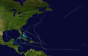
| Season summary map |
| First system formed |
August 2, 1898 |
| Last system dissipated |
November 4, 1898 |
| Strongest storm1 |
"Georgia" – 938 mbar (hPa) (27.7 inHg), 135 mph (215 km/h) |
| Total storms |
11 |
| Hurricanes |
5 |
| Major hurricanes (Cat. 3+) |
1 |
| Total fatalities |
≥562 total |
| Total damage |
At least $5.4 million (1898 USD) |
| 1Strongest storm is determined by lowest pressure |
Atlantic hurricane seasons
1896, 1897, 1898, 1899, 1900 |
The 1898 Atlantic hurricane season ran through the summer and the first half of fall in 1898. The season was a fairly active one, with 11 storms forming, 5 of which became hurricanes.
Storms
Hurricane One
| Category 1 hurricane (SSHWS) |
|
|
| Duration |
August 2 – August 3 |
| Peak intensity |
80 mph (130 km/h) (1-min) 982 mbar (hPa) |
A "feeble" tropical disturbance developed into a tropical storm near West End, Grand Bahama early on August 2.[1] Three hours later, the storm made landfall in Hobe Sound, Florida with winds of 40 mph (65 km/h). The system briefly weakened to a tropical depression on August 2, before re-strengthened into a tropical storm and emerged into the Gulf of Mexico near Tarpon Springs. Later that day, the cyclone intensified quickly, becoming a Category 1 hurricane on the modern-day Saffir–Simpson hurricane wind scale at 23:00 UTC. Simultaneously, the hurricane made landfall on St. George Island with winds of 80 mph (130 km/h). After moving inland, it rapidly weakened and dissipated over southwestern Alabama late on August 3.[2]
About 24 hours of heavy rainfall was observed in the Tampa area, with "great damage done in many places." In the Florida Panhandle, considerable impact was inflicted to crops, turpentine farms, and property. Offshore, three barges, four tugboats, and many sailing crafts were sunk. Among the capsized vessels was the tugboat Nimrod, with 12 people aboard, all of whom drowned.[1]
Hurricane Two
| Category 1 hurricane (SSHWS) |
|
|
| Duration |
August 30 – September 1 |
| Peak intensity |
85 mph (140 km/h) (1-min) 980 mbar (hPa) |
The next storm formed off the northern coast of Florida on August 30. It hit near the border of South Carolina and Georgia with 85 mph (137 km/h) winds, and dissipated on September 1, causing $400,000 in damage (1898 dollars).
At Port Royal, South Carolina, this storm caused 10.82 in (275 mm) of rain over the course of a day, breaking the previous one-day record by 5.89 in (150 mm).,[3] with a storm total of 12.4 inches (310 mm).[4]
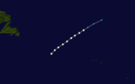
Hurricane Three
| Category 1 hurricane (SSHWS) |
|
|
| Duration |
September 3 – September 5 |
| Peak intensity |
80 mph (130 km/h) (1-min) |
A hurricane was first observed on September 3 over the northeastern Atlantic, likely having existed for several days prior. It headed northeastward, and became extratropical on September 5 north of the Azores.
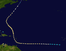
Hurricane Four
| Category 2 hurricane (SSHWS) |
|
|
| Duration |
September 5 – September 19 |
| Peak intensity |
110 mph (175 km/h) (1-min) 965 mbar (hPa) |
The next storm formed on September 5 off the coast of Africa. It moved westward and hit the Lesser Antilles with 110 mph (180 km/h) winds, where it caused heavy damage across the islands. The hurricane turned to the north, remaining a hurricane until becoming extratropical on September 19 near Newfoundland. The hurricane caused $2.5 million in damage and 383 deaths.
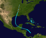
Tropical Storm Five
| Tropical storm (SSHWS) |
|
|
| Duration |
September 12 – September 22 |
| Peak intensity |
60 mph (95 km/h) (1-min) |
The fifth storm formed over the western Caribbean Sea on September 12. It tracked northwestward, and hit the Yucatán Peninsula with 60 mph (97 km/h) winds. Later, the storm traveled north. It hit Louisiana on September 20 with 60 mph (97 km/h) winds and dissipated over Illinois on September 22.
Tropical Storm Six
| Tropical storm (SSHWS) |
|
|
| Duration |
September 20 – September 28 |
| Peak intensity |
60 mph (95 km/h) (1-min) |
The sixth storm formed over the western Caribbean Sea on September 20. It followed a path similar to the fifth storm, tracking northwestward and hitting the Yucatán Peninsula with 60 mph (97 km/h) winds. Later, it traveled north. The system hit the United States near the Texas/Louisiana border on September 28, and dissipated shortly thereafter. Heavy rainfall fell across the central Gulf coast and up the Mississippi Valley, with the highest totals recorded at Pensacola, Florida with 12.61 inches (320 mm) and Sikeston, Missouri where 11.67 inches (296 mm) fell.[5]
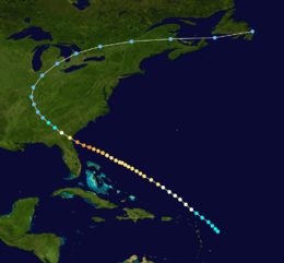
Hurricane Seven
| Category 4 hurricane (SSHWS) |
|
|
| Duration |
September 25 – October 6 |
| Peak intensity |
130 mph (215 km/h) (1-min) 938 mbar (hPa) |
The seventh storm formed to the east of the Lesser Antilles on September 25 and traveled northwest, reaching 110 mph (177 km/h) winds but sparing the islands. On the 2nd, it hit Cumberland Island, Georgia and northeast Florida with 135 mph (217 km/h) winds, causing heavy damage amounting to around $2.5 million, and 179 casualties. It dissipated after winding its way through Alabama, Tennessee, Kentucky, Indiana, Michigan, southern Canada, part of Maine, and Newfoundland on October 6. As of August 2010, this is the last major hurricane to make landfall in Georgia.[6]
Tropical Storm Eight
| Tropical storm (SSHWS) |
|
|
| Duration |
September 25 – September 28 |
| Peak intensity |
50 mph (85 km/h) (1-min) 1008 mbar (hPa) |
The eighth storm formed in the Western Caribbean, crossing to the northeast across Cuba, and dissipated over the Bahamas. It formed on September 25 and dissipated on September 28.
Tropical Storm Nine
| Tropical storm (SSHWS) |
|
|
| Duration |
October 2 – October 14 |
| Peak intensity |
70 mph (110 km/h) (1-min) |
A tropical wave forms into a tropical depression on October 2 with winds of 45 MPH. The storm moved across Cuba causing minor flooding and crop damage killing 2,then nearly struck Florida.It then moved to the North Eastern sea and dissipated October 14.
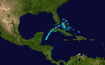
Tropical Storm Ten
| Tropical storm (SSHWS) |
|
|
| Duration |
October 21 – October 23 |
| Peak intensity |
45 mph (75 km/h) (1-min) |
The 10th storm of the season followed a path similar to the 8th storm, forming in the West Caribbean, crossing Cuba, and dissipating over the Bahamas. This storm lasted from October 21 to October 23
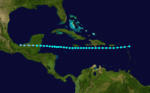
Tropical Storm Eleven
| Tropical storm (SSHWS) |
|
|
| Duration |
October 27 – November 4 |
| Peak intensity |
60 mph (95 km/h) (1-min) |
The final storm of the season formed over the Northern Lesser Antilles on October 27 and took a nearly straight-lined path to the west, hitting the Yucatán Peninsula with 60 mph (97 km/h) winds, and disintegrated soon after on November 4.
See also
References
External links