Climate of Missouri
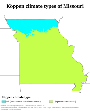
Missouri generally has a humid continental climate (Köppen climate classification Dfa), with cool to cold winters and long, hot summers. In the southern part of the state, particularly in the Bootheel, the climate borders on a humid subtropical climate (Köppen Cfa). An exception exits with St Louis, as it has more of a humid subtropical climate due to the region's abundance of rivers. Because of its location in the interior United States, Missouri often experiences extremes in temperatures. Lacking either large mountains or oceans nearby to moderate its temperature, its climate is alternately influenced by air from the cold Arctic and the hot and humid Gulf of Mexico.
Overview
| Month | Precipitation | Temp |
|---|---|---|
| Jan | 2.1 in | 29.8 °F |
| Feb | 2.0 in | 33.8 °F |
| March | 3.3 in | 43.5 °F |
| April | 4.0 in | 54.6 °F |
| May | 4.8 in | 64.2 °F |
| June | 4.65 in | 73 °F |
| July | 3.8 in | 77.6 °F |
| Aug | 3.7 in | 76 °F |
| Sep | 4.0 in | 68.3 °F |
| Oct | 3.2 in | 57.1 °F |
| Nov | 2.9 in | 44 °F |
| Dec | 2.4 in | 33.3 °F |
While the adjacent table would suggest a very mild climate, a temperature fluctuation of 20 degrees Fahrenheit on average and 30 to 40 degrees Fahrenheit (17 to 22 degrees Celsius) in a twenty-four-hour period is common. Although the mean temperature for June and July is only 73 °F and 76 °F (23 °C and 24 °C) it is not uncommon for the temperature to reach 100 °F (38 °C) at least three concurrent days each week in these months, as it did in 1904 during the World Fair where the temperature in St. Louis, Missouri was 103 °F (39 °C).
Statistics for selected cities
| Climate data for Columbia Regional Airport, Missouri (1981–2010 normals,[lower-alpha 1] extremes 1889–present)[lower-alpha 2] | |||||||||||||
|---|---|---|---|---|---|---|---|---|---|---|---|---|---|
| Month | Jan | Feb | Mar | Apr | May | Jun | Jul | Aug | Sep | Oct | Nov | Dec | Year |
| Record high °F (°C) | 77 (25) |
82 (28) |
92 (33) |
93 (34) |
101 (38) |
107 (42) |
113 (45) |
110 (43) |
104 (40) |
96 (36) |
84 (29) |
76 (24) |
113 (45) |
| Mean maximum °F (°C) | 61.9 (16.6) |
69.0 (20.6) |
79.0 (26.1) |
84.8 (29.3) |
86.9 (30.5) |
92.3 (33.5) |
96.9 (36.1) |
98.4 (36.9) |
91.5 (33.1) |
84.1 (28.9) |
74.4 (23.6) |
63.8 (17.7) |
99.5 (37.5) |
| Average high °F (°C) | 38.5 (3.6) |
43.9 (6.6) |
55.2 (12.9) |
66.1 (18.9) |
74.5 (23.6) |
83.0 (28.3) |
87.6 (30.9) |
87.0 (30.6) |
78.8 (26) |
67.1 (19.5) |
53.9 (12.2) |
41.1 (5.1) |
64.8 (18.2) |
| Average low °F (°C) | 20.9 (−6.2) |
24.9 (−3.9) |
34.0 (1.1) |
44.0 (6.7) |
53.5 (11.9) |
62.8 (17.1) |
67.0 (19.4) |
65.4 (18.6) |
56.4 (13.6) |
45.0 (7.2) |
34.9 (1.6) |
23.7 (−4.6) |
44.5 (6.9) |
| Mean minimum °F (°C) | 0.3 (−17.6) |
3.9 (−15.6) |
15.6 (−9.1) |
28.3 (−2.1) |
39.8 (4.3) |
50.8 (10.4) |
57.1 (13.9) |
54.9 (12.7) |
39.8 (4.3) |
29.4 (−1.4) |
17.9 (−7.8) |
3.5 (−15.8) |
−6.3 (−21.3) |
| Record low °F (°C) | −20 (−29) |
−26 (−32) |
−9 (−23) |
14 (−10) |
28 (−2) |
40 (4) |
45 (7) |
40 (4) |
26 (−3) |
19 (−7) |
−3 (−19) |
−23 (−31) |
−26 (−32) |
| Average precipitation inches (mm) | 1.92 (48.8) |
2.25 (57.2) |
2.91 (73.9) |
4.49 (114) |
4.98 (126.5) |
4.47 (113.5) |
4.37 (111) |
4.36 (110.7) |
3.87 (98.3) |
3.31 (84.1) |
3.25 (82.6) |
2.44 (62) |
42.62 (1,082.5) |
| Average snowfall inches (cm) | 6.1 (15.5) |
4.7 (11.9) |
1.7 (4.3) |
0.2 (0.5) |
0 (0) |
0 (0) |
0 (0) |
0 (0) |
0 (0) |
0 (0) |
0.9 (2.3) |
4.4 (11.2) |
18.0 (45.7) |
| Average precipitation days (≥ 0.01 in) | 7.7 | 8.0 | 10.6 | 10.8 | 12.5 | 9.7 | 8.8 | 8.6 | 8.1 | 9.5 | 9.7 | 8.4 | 112.4 |
| Average snowy days (≥ 0.1 in) | 3.6 | 3.3 | 1.3 | 0.2 | 0 | 0 | 0 | 0 | 0 | 0 | 1.0 | 2.5 | 11.9 |
| Average relative humidity (%) | 71.2 | 71.5 | 67.3 | 63.9 | 70.9 | 71.3 | 69.5 | 70.8 | 71.7 | 69.4 | 71.8 | 74.0 | 70.3 |
| Mean monthly sunshine hours | 161.5 | 154.3 | 193.5 | 226.9 | 264.1 | 294.1 | 313.4 | 288.5 | 229.1 | 210.7 | 150.6 | 140.3 | 2,627 |
| Percent possible sunshine | 53 | 51 | 52 | 57 | 60 | 66 | 69 | 68 | 61 | 61 | 50 | 48 | 59 |
| Source: NOAA (relative humidity 1969–1990, sun 1961–1990)[2][3][4] | |||||||||||||
| Climate data for Kansas City, Missouri (Downtown Airport), 1981–2010 normals,[lower-alpha 3] extremes 1934–present) | |||||||||||||
|---|---|---|---|---|---|---|---|---|---|---|---|---|---|
| Month | Jan | Feb | Mar | Apr | May | Jun | Jul | Aug | Sep | Oct | Nov | Dec | Year |
| Record high °F (°C) | 76 (24) |
83 (28) |
89 (32) |
94 (34) |
103 (39) |
108 (42) |
112 (44) |
113 (45) |
109 (43) |
98 (37) |
83 (28) |
74 (23) |
113 (45) |
| Mean maximum °F (°C) | 61.5 (16.4) |
68.1 (20.1) |
78.1 (25.6) |
84.4 (29.1) |
89.3 (31.8) |
94.8 (34.9) |
100.1 (37.8) |
100.3 (37.9) |
93.3 (34.1) |
84.8 (29.3) |
73.5 (23.1) |
62.8 (17.1) |
102.1 (38.9) |
| Average high °F (°C) | 39.5 (4.2) |
44.6 (7) |
56.2 (13.4) |
66.7 (19.3) |
75.9 (24.4) |
85.0 (29.4) |
90.1 (32.3) |
88.6 (31.4) |
80.0 (26.7) |
67.8 (19.9) |
54.2 (12.3) |
41.8 (5.4) |
65.9 (18.8) |
| Average low °F (°C) | 22.4 (−5.3) |
26.3 (−3.2) |
35.8 (2.1) |
46.6 (8.1) |
57.1 (13.9) |
66.7 (19.3) |
72.0 (22.2) |
70.2 (21.2) |
60.5 (15.8) |
48.9 (9.4) |
36.6 (2.6) |
25.6 (−3.6) |
47.4 (8.6) |
| Mean minimum °F (°C) | 3.7 (−15.7) |
6.5 (−14.2) |
16.9 (−8.4) |
30.6 (−0.8) |
43.2 (6.2) |
54.6 (12.6) |
62.0 (16.7) |
59.4 (15.2) |
44.3 (6.8) |
32.8 (0.4) |
20.0 (−6.7) |
5.3 (−14.8) |
−2.7 (−19.3) |
| Record low °F (°C) | −14 (−26) |
−13 (−25) |
−3 (−19) |
16 (−9) |
32 (0) |
44 (7) |
52 (11) |
48 (9) |
34 (1) |
21 (−6) |
5 (−15) |
−19 (−28) |
−19 (−28) |
| Average precipitation inches (mm) | 1.14 (29) |
1.48 (37.6) |
2.15 (54.6) |
3.71 (94.2) |
5.13 (130.3) |
5.52 (140.2) |
3.97 (100.8) |
4.39 (111.5) |
4.16 (105.7) |
3.52 (89.4) |
2.14 (54.4) |
1.75 (44.4) |
39.06 (992.1) |
| Average snowfall inches (cm) | 4.1 (10.4) |
3.2 (8.1) |
0.9 (2.3) |
0.2 (0.5) |
0 (0) |
0 (0) |
0 (0) |
0 (0) |
0 (0) |
0.3 (0.8) |
0.3 (0.8) |
4.4 (11.2) |
13.4 (34) |
| Average precipitation days (≥ 0.01 in) | 4.8 | 5.3 | 7.6 | 9.4 | 11.0 | 10.2 | 7.9 | 7.5 | 8.1 | 7.5 | 6.1 | 5.4 | 90.8 |
| Average snowy days (≥ 0.1 in) | 2.5 | 2.1 | 0.6 | 0.1 | 0 | 0 | 0 | 0 | 0 | 0.1 | 0.4 | 2.5 | 8.3 |
| Source: NOAA[5][6][7] | |||||||||||||
| Climate data for Kansas City Int'l, Missouri (1981–2010 normals,[lower-alpha 3] extremes 1888–present)[lower-alpha 4] | |||||||||||||
|---|---|---|---|---|---|---|---|---|---|---|---|---|---|
| Month | Jan | Feb | Mar | Apr | May | Jun | Jul | Aug | Sep | Oct | Nov | Dec | Year |
| Record high °F (°C) | 75 (24) |
83 (28) |
91 (33) |
95 (35) |
103 (39) |
108 (42) |
112 (44) |
113 (45) |
109 (43) |
98 (37) |
83 (28) |
74 (23) |
113 (45) |
| Mean maximum °F (°C) | 60.6 (15.9) |
67.4 (19.7) |
78.4 (25.8) |
84.5 (29.2) |
88.2 (31.2) |
92.9 (33.8) |
98.1 (36.7) |
99.0 (37.2) |
92.6 (33.7) |
84.9 (29.4) |
72.5 (22.5) |
61.9 (16.6) |
100.5 (38.1) |
| Average high °F (°C) | 38.0 (3.3) |
43.3 (6.3) |
55.1 (12.8) |
65.7 (18.7) |
74.8 (23.8) |
83.5 (28.6) |
88.3 (31.3) |
87.4 (30.8) |
79.0 (26.1) |
66.9 (19.4) |
53.2 (11.8) |
40.3 (4.6) |
64.6 (18.1) |
| Average low °F (°C) | 19.6 (−6.9) |
23.8 (−4.6) |
33.4 (0.8) |
44.0 (6.7) |
54.2 (12.3) |
63.6 (17.6) |
68.4 (20.2) |
66.8 (19.3) |
57.3 (14.1) |
45.9 (7.7) |
34.1 (1.2) |
22.6 (−5.2) |
44.5 (6.9) |
| Mean minimum °F (°C) | −0.1 (−17.8) |
2.6 (−16.3) |
13.8 (−10.1) |
27.0 (−2.8) |
40.0 (4.4) |
50.3 (10.2) |
57.9 (14.4) |
55.1 (12.8) |
40.3 (4.6) |
28.6 (−1.9) |
16.7 (−8.5) |
1.7 (−16.8) |
−7 (−22) |
| Record low °F (°C) | −20 (−29) |
−22 (−30) |
−10 (−23) |
12 (−11) |
27 (−3) |
42 (6) |
51 (11) |
43 (6) |
31 (−1) |
17 (−8) |
1 (−17) |
−23 (−31) |
−23 (−31) |
| Average precipitation inches (mm) | 1.07 (27.2) |
1.46 (37.1) |
2.37 (60.2) |
3.70 (94) |
5.23 (132.8) |
5.23 (132.8) |
4.45 (113) |
3.89 (98.8) |
4.62 (117.3) |
3.16 (80.3) |
2.15 (54.6) |
1.53 (38.9) |
38.86 (987) |
| Average snowfall inches (cm) | 4.6 (11.7) |
5.4 (13.7) |
2.0 (5.1) |
0.6 (1.5) |
0 (0) |
0 (0) |
0 (0) |
0 (0) |
0 (0) |
0.2 (0.5) |
1.2 (3) |
4.8 (12.2) |
18.8 (47.8) |
| Average precipitation days (≥ 0.01 in) | 6.3 | 7.1 | 9.5 | 11.0 | 11.5 | 10.8 | 9.0 | 8.3 | 8.6 | 8.2 | 7.3 | 7.2 | 104.8 |
| Average snowy days (≥ 0.1 in) | 4.0 | 3.5 | 1.6 | 0.5 | 0 | 0 | 0 | 0 | 0 | 0.1 | 1.2 | 3.7 | 14.6 |
| Average relative humidity (%) | 68.8 | 69.6 | 66.7 | 62.9 | 68.0 | 69.2 | 67.4 | 70.0 | 70.4 | 67.1 | 69.7 | 71.0 | 68.4 |
| Mean monthly sunshine hours | 183.7 | 174.3 | 223.9 | 257.8 | 285.0 | 305.5 | 329.3 | 293.9 | 240.5 | 213.6 | 155.3 | 147.1 | 2,809.9 |
| Percent possible sunshine | 61 | 58 | 60 | 65 | 64 | 68 | 73 | 69 | 64 | 62 | 52 | 50 | 63 |
| Source: NOAA (relative humidity and sun 1961–1990)[5][8][9][10] | |||||||||||||
| Climate data for St. Louis, Missouri (Lambert–St. Louis Int'l), 1981−2010 normals,[lower-alpha 5] extremes 1874−present[lower-alpha 6] | |||||||||||||
|---|---|---|---|---|---|---|---|---|---|---|---|---|---|
| Month | Jan | Feb | Mar | Apr | May | Jun | Jul | Aug | Sep | Oct | Nov | Dec | Year |
| Record high °F (°C) | 77 (25) |
85 (29) |
92 (33) |
93 (34) |
98 (37) |
108 (42) |
115 (46) |
110 (43) |
104 (40) |
94 (34) |
86 (30) |
76 (24) |
115 (46) |
| Mean maximum °F (°C) | 64.1 (17.8) |
69.8 (21) |
80.2 (26.8) |
86.7 (30.4) |
89.4 (31.9) |
94.8 (34.9) |
98.5 (36.9) |
99.3 (37.4) |
92.7 (33.7) |
85.7 (29.8) |
75.6 (24.2) |
65.0 (18.3) |
100.4 (38) |
| Average high °F (°C) | 39.9 (4.4) |
45.0 (7.2) |
55.9 (13.3) |
67.4 (19.7) |
76.3 (24.6) |
85.1 (29.5) |
89.1 (31.7) |
87.9 (31.1) |
80.2 (26.8) |
68.5 (20.3) |
55.5 (13.1) |
42.5 (5.8) |
66.2 (19) |
| Average low °F (°C) | 23.7 (−4.6) |
27.6 (−2.4) |
36.6 (2.6) |
47.2 (8.4) |
57.2 (14) |
66.8 (19.3) |
71.0 (21.7) |
69.4 (20.8) |
60.6 (15.9) |
49.0 (9.4) |
38.1 (3.4) |
26.9 (−2.8) |
47.9 (8.8) |
| Mean minimum °F (°C) | 4.2 (−15.4) |
8.0 (−13.3) |
18.4 (−7.6) |
31.5 (−0.3) |
43.2 (6.2) |
54.3 (12.4) |
60.3 (15.7) |
59.0 (15) |
44.8 (7.1) |
33.5 (0.8) |
22.4 (−5.3) |
7.5 (−13.6) |
−1.8 (−18.8) |
| Record low °F (°C) | −22 (−30) |
−18 (−28) |
−5 (−21) |
20 (−7) |
31 (−1) |
43 (6) |
51 (11) |
47 (8) |
32 (0) |
21 (−6) |
1 (−17) |
−16 (−27) |
−22 (−30) |
| Average precipitation inches (mm) | 2.40 (61) |
2.24 (56.9) |
3.32 (84.3) |
3.69 (93.7) |
4.72 (119.9) |
4.28 (108.7) |
4.11 (104.4) |
2.99 (75.9) |
3.13 (79.5) |
3.33 (84.6) |
3.91 (99.3) |
2.84 (72.1) |
40.96 (1,040.4) |
| Average snowfall inches (cm) | 5.6 (14.2) |
4.3 (10.9) |
2.3 (5.8) |
0.4 (1) |
0 (0) |
0 (0) |
0 (0) |
0 (0) |
0 (0) |
0 (0) |
0.7 (1.8) |
4.4 (11.2) |
17.7 (45) |
| Average precipitation days (≥ 0.01 in) | 8.9 | 8.0 | 10.3 | 11.3 | 11.9 | 10.0 | 8.9 | 8.2 | 7.4 | 8.7 | 9.6 | 9.4 | 112.6 |
| Average snowy days (≥ 0.1 in) | 4.7 | 3.4 | 1.7 | 0.3 | 0 | 0 | 0 | 0 | 0 | 0 | 0.7 | 3.7 | 14.5 |
| Average relative humidity (%) | 73.0 | 72.0 | 68.3 | 63.5 | 66.5 | 67.1 | 68.0 | 70.0 | 71.6 | 68.7 | 72.2 | 75.8 | 69.7 |
| Mean monthly sunshine hours | 161.2 | 158.3 | 198.3 | 223.5 | 266.5 | 291.9 | 308.9 | 269.8 | 236.1 | 208.4 | 140.9 | 129.9 | 2,593.7 |
| Percent possible sunshine | 53 | 53 | 53 | 56 | 60 | 66 | 68 | 64 | 63 | 60 | 47 | 44 | 58 |
| Source: NOAA (relative humidity and sun 1961−1990)[12][3][13] | |||||||||||||
| Climate data for Springfield–Branson National Airport, Missouri (1981−2010 normals,[lower-alpha 7] extremes 1888−present[lower-alpha 8]) | |||||||||||||
|---|---|---|---|---|---|---|---|---|---|---|---|---|---|
| Month | Jan | Feb | Mar | Apr | May | Jun | Jul | Aug | Sep | Oct | Nov | Dec | Year |
| Record high °F (°C) | 76 (24) |
84 (29) |
92 (33) |
93 (34) |
95 (35) |
101 (38) |
113 (45) |
108 (42) |
104 (40) |
93 (34) |
83 (28) |
77 (25) |
113 (45) |
| Mean maximum °F (°C) | 65.6 (18.7) |
71.1 (21.7) |
78.8 (26) |
83.7 (28.7) |
86.9 (30.5) |
92.4 (33.6) |
96.9 (36.1) |
98.2 (36.8) |
92.3 (33.5) |
84.2 (29) |
75.0 (23.9) |
66.3 (19.1) |
99.6 (37.6) |
| Average high °F (°C) | 42.9 (6.1) |
48.2 (9) |
57.5 (14.2) |
67.2 (19.6) |
75.3 (24.1) |
83.8 (28.8) |
88.8 (31.6) |
89.0 (31.7) |
80.3 (26.8) |
69.0 (20.6) |
56.7 (13.7) |
44.9 (7.2) |
67.1 (19.5) |
| Average low °F (°C) | 22.4 (−5.3) |
26.1 (−3.3) |
35.2 (1.8) |
44.3 (6.8) |
54.4 (12.4) |
63.1 (17.3) |
67.6 (19.8) |
66.6 (19.2) |
57.7 (14.3) |
46.5 (8.1) |
35.4 (1.9) |
25.0 (−3.9) |
45.5 (7.5) |
| Mean minimum °F (°C) | 3.0 (−16.1) |
7.2 (−13.8) |
16.3 (−8.7) |
27.8 (−2.3) |
39.3 (4.1) |
50.2 (10.1) |
57.1 (13.9) |
54.6 (12.6) |
40.0 (4.4) |
29.4 (−1.4) |
18.4 (−7.6) |
5.0 (−15) |
−3 (−19) |
| Record low °F (°C) | −19 (−28) |
−29 (−34) |
−8 (−22) |
16 (−9) |
29 (−2) |
42 (6) |
44 (7) |
44 (7) |
30 (−1) |
18 (−8) |
4 (−16) |
−16 (−27) |
−29 (−34) |
| Average precipitation inches (mm) | 2.47 (62.7) |
2.52 (64) |
3.62 (91.9) |
4.32 (109.7) |
5.10 (129.5) |
4.85 (123.2) |
3.68 (93.5) |
3.55 (90.2) |
4.61 (117.1) |
3.59 (91.2) |
4.22 (107.2) |
3.04 (77.2) |
45.57 (1,157.5) |
| Average snowfall inches (cm) | 5.4 (13.7) |
3.6 (9.1) |
2.4 (6.1) |
trace | 0 (0) |
0 (0) |
0 (0) |
0 (0) |
0 (0) |
trace | 0.7 (1.8) |
4.9 (12.4) |
17.0 (43.2) |
| Average precipitation days (≥ 0.01 in) | 8.2 | 7.8 | 10.5 | 10.5 | 12.0 | 10.6 | 8.4 | 7.9 | 7.6 | 9.5 | 9.4 | 8.9 | 111.3 |
| Average snowy days (≥ 0.1 in) | 3.5 | 2.9 | 1.4 | 0.1 | 0 | 0 | 0 | 0 | 0 | 0.1 | 0.7 | 2.8 | 11.5 |
| Average relative humidity (%) | 68.3 | 68.5 | 65.2 | 64.5 | 70.7 | 72.3 | 70.4 | 69.5 | 72.9 | 68.2 | 69.6 | 70.9 | 69.3 |
| Mean monthly sunshine hours | 167.6 | 157.4 | 208.7 | 236.4 | 268.0 | 282.7 | 321.6 | 292.1 | 237.6 | 217.3 | 155.1 | 145.9 | 2,690.4 |
| Percent possible sunshine | 54 | 52 | 56 | 60 | 61 | 64 | 72 | 70 | 64 | 62 | 51 | 49 | 60 |
| Source: NOAA (relative humidity and sun 1961−1990)[14][15][10] | |||||||||||||
Spring
April through June is generally the wettest season of the year, with the mean temperature from 1895 until 2003 being about 12 °C (54 °F) and its mean precipitation (in the form of rain) for this period being approximately 300 mm (12 inches). The spring rains often continue through June. The spring also produces the most tornadoes, with an average of 35 tornadoes each year.
Summer
Summer, June through August, is the hottest time of the year with a mean temperature of 24 °C (75 °F, 24 °C) and a mean precipitation of 300 mm (12 inches) with June having more precipitation than either July or August. The extreme highs for the year often occur in July or August. Tropical cyclones and their remains can impact the state during this time of the year, contributing to area rainfall.
Autumn
Fall, September through November, has less and less precipitation towards the end of the season. The mean temperatures for this season are 13.6 °C (56.5 °F) and the mean precipitation is 250mm (10 in). Tropical cyclones and their remains can impact the state into October, contributing to area rainfall.
Winter

Winters in Missouri can be long with temperatures ranging from mildly to bitterly cold. Kansas City's average January low is 26 °F (−3 °C) and St. Louis's average January low is 29 °F (−2 °C). The coldest temperature ever recorded in Missouri was −40 °F (−40 °C), set at Warsaw on 13 February 1905. Winter also tends to be the driest season, but typically yields significant amounts of winter precipitation. Snowfall averages 20 inches (51 cm) in the state's northern region, and 10 inches (25 cm) in the southeast. During the winter, northwest winds prevail; the air movement is largely from the south and southeast during the rest of the year.[16]
See also
- Climate
- Climatology
- List of wettest known tropical cyclones, and their remnants, across Missouri
- St. Louis tornado history
Notes
- ↑ Mean monthly maxima and minima (i.e. the highest and lowest temperature readings during an entire month or year) calculated based on data at said location from 1981 to 2010.
- ↑ Official records for Columbia kept at downtown from August 1889 to December 1947, Columbia Municipal Airport from January 1948 to October 1969 and at Columbia Regional Airport since November 1969.[1]
- 1 2
- ↑ Official records for Kansas City kept at downtown/Weather Bureau Office from July 1888 to December 1933; Downtown Airport from January 1934 to September 1972; and Kansas City Int'l since October 1972. For more information see ThreadEx.
- ↑ Mean monthly maxima and minima (i.e. the highest and lowest temperature readings during an entire month or year) calculated based on data at said location from 1981 to 2010.
- ↑ Official records for St. Louis were kept at the Weather Bureau Office from January 1874 to December 1892, Eads Bridge from January 1893 to December 1929, and at Lambert–St. Louis Int'l since January 1930.[11]
- ↑ Mean monthly maxima and minima (i.e. the highest and lowest temperature readings during an entire month or year) calculated based on data at said location from 1981 to 2010.
- ↑ Official records for Springfield were kept at downtown from January 1888 to December 1939, Downtown Airport from January 1940 to July 1940, and at Springfield–Branson National Airport since August 1940. For more information, see ThreadEx.
References
- ↑ ThreadEx
- ↑ "Station Name: MO COLUMBIA RGNL AP". National Oceanic and Atmospheric Administration. Retrieved 2016-09-07.
- 1 2 "NowData - NOAA Online Weather Data". National Oceanic and Atmospheric Administration. Retrieved 2016-09-07.
- ↑ "WMO Climate Normals for COLUMBIA/REGIONAL ARPT MO 1961–1990". National Oceanic and Atmospheric Administration. Retrieved 2014-03-11.
- 1 2 "NowData – NOAA Online Weather Data". National Oceanic and Atmospheric Administration. Retrieved 2016-04-19.
- ↑ "Station Name: MO KANSAS CITY DOWNTOWN AP". National Oceanic and Atmospheric Administration. Retrieved 2014-03-13.
- ↑ "Kansas City Daily Climate Records/Normals". National Oceanic and Atmospheric Administration. Retrieved February 12, 2011.
- ↑ "Station Name: MO KANSAS CITY INTL AP". National Oceanic and Atmospheric Administration. Retrieved 2014-03-26.
- ↑ "Kansas City Daily Climate Records/Normals". National Oceanic and Atmospheric Administration. Retrieved February 12, 2011.
- 1 2 "WMO Climate Normals for KANSAS CITY/INTL ARPT MO 1961–1990". National Oceanic and Atmospheric Administration. Retrieved 2014-03-11.
- ↑ ThreadEx
- ↑ "Station Name: MO ST LOUIS LAMBERT INTL AP". National Oceanic and Atmospheric Administration. Retrieved 2016-09-07.
- ↑ "WMO Climate Normals for ST. LOUIS/LAMBERT, MO 1961–1990". National Oceanic and Atmospheric Administration. Retrieved 2014-03-11.
- ↑ "NowData - NOAA Online Weather Data". National Oceanic and Atmospheric Administration. Retrieved 2016-09-07.
- ↑ "Station Name: MO SPRINGFIELD". National Oceanic and Atmospheric Administration. Retrieved 2016-09-07.
- ↑ Missouri-Climate