Cho La, Sikkim
| Cho La | |
|---|---|
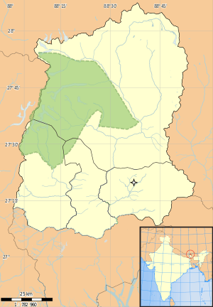 Cho La Location in Sikkim | |
| Elevation | 4,500 m (14,764 ft)[1] |
| Location | India (Sikkim) – China (Tibet Autonomous Region) |
| Range | Himalaya |
| Coordinates | 27°25′10″N 88°48′15″E / 27.41949°N 88.8041546°ECoordinates: 27°25′10″N 88°48′15″E / 27.41949°N 88.8041546°E |
Cho La or Cho-la (lit. Cho Pass in Tibetan[2]) is a mountain pass in the Himalayas. It connects the Indian state of Sikkim with China's Tibet Autonomous Region. It is situated around four miles to the north-west of Nathu La.[3]
The pass was the scene of a clash between Chinese and Indian troops on 1 October, 1967.[4]
See also
References
- ↑ "Introduction to Sikkim's Physiography". Sikkim Biodiversity Board. Retrieved 29 August 2015.
- ↑ Pradhan, Keshav (6 July 2006). "In the good ol' days of Nathu-la". Times of India, Mumbai. Bennett, Coleman & Co. Ltd. p. 10.
- ↑ Bajpai, G. S. (1999). China's shadow over Sikkim : the politics of intimidation. New Delhi [u.a.]: Lancer Publ. p. 193. ISBN 9781897829523. Retrieved 29 August 2015.
- ↑ "Sikkim, Red China Clash Renewed". The Dispatch (Lexington). 2 October 1967. p. 5. Retrieved 29 August 2015.
This article is issued from Wikipedia - version of the 8/29/2015. The text is available under the Creative Commons Attribution/Share Alike but additional terms may apply for the media files.