Chang La
| Chang La | |
|---|---|
 | |
| Elevation | 5,360 m (17,585 ft) |
| Traversed by | Road from Indus Valley to Pangong Lake |
| Location | India |
| Range | Himalaya |
| Coordinates | 34°03′32″N 77°55′51″E / 34.058917°N 77.930832°ECoordinates: 34°03′32″N 77°55′51″E / 34.058917°N 77.930832°E |
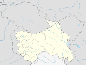  Location of Chang La in Jammu & Kashmir | |
The Chang La (el. 5,360 m or 17,590 ft) is a high mountain pass in Ladakh, India.[1][2] It is claimed to be the second highest motorable road in the world (which is either Merisimik La or Mana pass). Chang La is approached from Leh via Kharu and Sekti village by an asphalt road. The climb is very steep and requires a careful drive.During the summer months specifically the tourist season, small streams appear across the road, making the climb a challenge for the bikers. The descent from Chang La towards Tangtse or Darbuk is again very steep. As per the medics, it is advisable to not stay at the top for more than 20-25 mins as it could be detrimental to health owing to its high altitude.
The Chang La is on the route to Pangong Lake from Leh. The name literally means "Pass towards the South" or "Pass in the South" (Chang = south, La = Pass). It is falsely claimed that the pass is named after the supposed sadhu Changla Baba, a myth propagated by the dedication of a temple at the pass to the supposed Changla Baba. If any such sadhu exists or existed, he would have been named for the pass, rather than vice versa (since the name "changla baba" means the "baba of the southern pass". The small town of Tangste is the nearest settlement. The Changla Pass is the main gateway for the Changthang Plateau situated in the Himalayas. The nomadic tribes of the region are collectively known as the Changpa or Chang-pa. The world’s highest research station, established by the Defence Research and Development Organisation is functional in Chang La at a height of 17,500 ft.[3]
-

Chang La with prayer flags
-

Chang La, Tea Point, everyone is welcome
References
- ↑ GeoNames. "Chang La Pass". Retrieved 2009-06-17.
- ↑ Jina, Prem Singh (31 August 1998). Ladakh: The Land & The People. India: Indus Publishing. pp. 25–26. ISBN 978-81-7387-057-6.
- ↑ "At 17,500 ft, world's highest research station becomes functional in Ladakh".