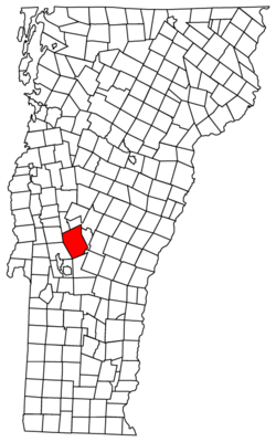
Chittenden, Vermont
| Chittenden, Vermont | ||
|---|---|---|
| Town | ||
| ||
 Chittenden, Vermont | ||
| Coordinates: 43°43′58″N 72°56′15″W / 43.73278°N 72.93750°WCoordinates: 43°43′58″N 72°56′15″W / 43.73278°N 72.93750°W | ||
| Country | United States | |
| State | Vermont | |
| County | Rutland | |
| Area | ||
| • Total | 74.2 sq mi (192.2 km2) | |
| • Land | 73.0 sq mi (189.1 km2) | |
| • Water | 1.2 sq mi (3.1 km2) | |
| Elevation | 1,496 ft (456 m) | |
| Population (2010) | ||
| • Total | 1,258 | |
| • Density | 17/sq mi (6.5/km2) | |
| Time zone | Eastern (EST) (UTC-5) | |
| • Summer (DST) | EDT (UTC-4) | |
| ZIP code | 05737 | |
| Area code(s) | 802 | |
| FIPS code | 50-14350[1] | |
| GNIS feature ID | 1462071[2] | |

Chittenden (/ˈtʃɪtəndən/) is a town in Rutland County, Vermont, United States. The population was 1,258 at the 2010 census.[3]
History
By area the largest town in the state, Chittenden was named after Thomas Chittenden, one of the Green Mountain Boys and governor of both the independent Vermont Republic, and later, the state of Vermont. Chittenden and his son Noah were among the town's principal land grantees, although the governor may have never visited the area.
The Chittenden Reservoir is a popular regional swimming and boating area.
Geography
According to the United States Census Bureau, the town has a total area of 74.2 square miles (192.2 km2), of which 73.0 square miles (189.1 km2) is land and 1.2 square miles (3.1 km2 or 1.62%) is water. It is the largest town by area in Vermont, slightly larger than Stowe in Lamoille County.
The town is split in two by a ridge of the Green Mountains, and only the western half of the town is settled. Much of the town remains unbroken forest.
Demographics
| Historical population | |||
|---|---|---|---|
| Census | Pop. | %± | |
| 1790 | 159 | — | |
| 1800 | 327 | 105.7% | |
| 1810 | 446 | 36.4% | |
| 1820 | 528 | 18.4% | |
| 1830 | 610 | 15.5% | |
| 1840 | 644 | 5.6% | |
| 1850 | 675 | 4.8% | |
| 1860 | 763 | 13.0% | |
| 1870 | 802 | 5.1% | |
| 1880 | 1,092 | 36.2% | |
| 1890 | 730 | −33.2% | |
| 1900 | 621 | −14.9% | |
| 1910 | 563 | −9.3% | |
| 1920 | 472 | −16.2% | |
| 1930 | 341 | −27.8% | |
| 1940 | 379 | 11.1% | |
| 1950 | 424 | 11.9% | |
| 1960 | 460 | 8.5% | |
| 1970 | 646 | 40.4% | |
| 1980 | 927 | 43.5% | |
| 1990 | 1,102 | 18.9% | |
| 2000 | 1,182 | 7.3% | |
| 2010 | 1,258 | 6.4% | |
| Est. 2014 | 1,237 | [4] | −1.7% |
| U.S. Decennial Census[5] | |||
At the 2000 census,[1] there were 1,182 people, 451 households and 345 families residing in the town. The population density was 16.2 per square mile (6.3/km2). There were 585 housing units at an average density of 8.0 per square mile (3.1/km2). The racial makeup of the town was 98.48% White, 0.17% African American, 0.17% Asian, 0.08% Pacific Islander, and 1.10% from two or more races. Hispanic or Latino of any race were 0.25% of the population.
There were 451 households of which 37.3% had children under the age of 18 living with them, 64.1% were married couples living together, 7.3% had a female householder with no husband present, and 23.5% were non-families. 18.6% of all households were made up of individuals and 6.4% had someone living alone who was 65 years of age or older. The average household size was 2.62 and the average family size was 2.97.
26.3% of the population were under the age of 18, 5.8% from 18 to 24, 29.2% from 25 to 44, 30.3% from 45 to 64, and 8.4% who were 65 years of age or older. The median age was 40 years. For every 100 females there were 99.3 males. For every 100 females age 18 and over, there were 100.7 males.
The median household income was $45,313 and the median family income was $52,596. Males had a median income of $35,556 versus $31,776 for females. The per capita income for the town was $21,278. About 2.9% of families and 6.2% of the population were below the poverty line, including 6.1% of those under age 18 and 5.2% of those age 65 or over.
Notable people
- The Eddy Brothers, traveling sideshow psychic twins
Climate
This climatic region is typified by large seasonal temperature differences, with warm to hot (and often humid) summers and cold (sometimes severely cold) winters. According to the Köppen Climate Classification system, Chittenden has a humid continental climate, abbreviated "Dfb" on climate maps.[6]
References
- 1 2 "American FactFinder". United States Census Bureau. Archived from the original on 2013-09-11. Retrieved 2008-01-31.
- ↑ "US Board on Geographic Names". United States Geological Survey. 2007-10-25. Retrieved 2008-01-31.
- ↑ "Race, Hispanic or Latino, Age, and Housing Occupancy: 2010 Census Redistricting Data (Public Law 94-171) Summary File (QT-PL), Chittenden town, Vermont". U.S. Census Bureau, American FactFinder 2. Archived from the original on September 11, 2013. Retrieved November 2, 2011.
- ↑ "Annual Estimates of the Resident Population for Incorporated Places: April 1, 2010 to July 1, 2014". Retrieved June 4, 2015.
- ↑ "U.S. Decennial Census". United States Census Bureau. Archived from the original on May 11, 2015. Retrieved May 16, 2015.
- ↑ Climate Summary for Chittenden, Vermont
Municipalities and communities of Rutland County, Vermont, United States | ||
|---|---|---|
| City | 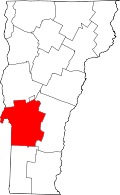 | |
| Towns | ||
| Village | ||
| CDPs | ||
| Other communities | ||