Ira, Vermont
| Ira, Vermont | |
|---|---|
| Town | |
|
Ira town hall | |
 Ira, Vermont | |
| Coordinates: 43°32′N 73°4′W / 43.533°N 73.067°WCoordinates: 43°32′N 73°4′W / 43.533°N 73.067°W | |
| Country | United States |
| State | Vermont |
| County | Rutland |
| Area | |
| • Total | 21.3 sq mi (55.2 km2) |
| • Land | 21.3 sq mi (55.2 km2) |
| • Water | 0.0 sq mi (0.0 km2) |
| Elevation | 1,076 ft (328 m) |
| Population (2010) | |
| • Total | 432 |
| • Density | 20/sq mi (7.8/km2) |
| Time zone | Eastern (EST) (UTC-5) |
| • Summer (DST) | EDT (UTC-4) |
| ZIP code | 05777 |
| Area code(s) | 802 |
| FIPS code | 50-35425[1] |
| GNIS feature ID | 1462123[2] |

Ira is a town in Rutland County, Vermont, United States. The population was 432 at the 2010 census.[3] It was named for Ira Allen, brother of Ethan Allen, who fought with the Green Mountain Boys of the Revolutionary War.[4][5]
Geography
According to the United States Census Bureau, the town has a total area of 21.3 square miles (55.2 km2), all land.
History
Following the Revolutionary War, veteran and historian Lemuel Roberts served as Captain of the Ira militia.[6]
Demographics
| Historical population | |||
|---|---|---|---|
| Census | Pop. | %± | |
| 1790 | 312 | — | |
| 1800 | 473 | 51.6% | |
| 1810 | 519 | 9.7% | |
| 1820 | 498 | −4.0% | |
| 1830 | 442 | −11.2% | |
| 1840 | 430 | −2.7% | |
| 1850 | 400 | −7.0% | |
| 1860 | 422 | 5.5% | |
| 1870 | 413 | −2.1% | |
| 1880 | 479 | 16.0% | |
| 1890 | 421 | −12.1% | |
| 1900 | 350 | −16.9% | |
| 1910 | 286 | −18.3% | |
| 1920 | 295 | 3.1% | |
| 1930 | 287 | −2.7% | |
| 1940 | 248 | −13.6% | |
| 1950 | 232 | −6.5% | |
| 1960 | 220 | −5.2% | |
| 1970 | 284 | 29.1% | |
| 1980 | 354 | 24.6% | |
| 1990 | 426 | 20.3% | |
| 2000 | 455 | 6.8% | |
| 2010 | 432 | −5.1% | |
| Est. 2014 | 428 | [7] | −0.9% |
| U.S. Decennial Census[8] | |||
As of the census[1] of 2000, there were 455 people, 163 households, and 125 families residing in the town. The population density was 21.3 people per square mile (8.2/km2). There were 192 housing units at an average density of 9.0 per square mile (3.5/km2). The racial makeup of the town was 99.78% White and 0.22% Asian.
There were 163 households out of which 40.5% had children under the age of 18 living with them, 63.2% were married couples living together, 9.2% had a female householder with no husband present, and 22.7% were non-families. 18.4% of all households were made up of individuals and 6.1% had someone living alone who was 65 years of age or older. The average household size was 2.79 and the average family size was 3.18.
In the town the population was spread out with 29.5% under the age of 18, 8.1% from 18 to 24, 28.1% from 25 to 44, 25.9% from 45 to 64, and 8.4% who were 65 years of age or older. The median age was 38 years. For every 100 females there were 85.0 males. For every 100 females age 18 and over, there were 88.8 males.
The median income for a household in the town was $46,875, and the median income for a family was $51,375. Males had a median income of $31,500 versus $26,042 for females. The per capita income for the town was $16,756. About 6.5% of families and 10.4% of the population were below the poverty line, including 19.7% of those under age 18 and none of those age 65 or over.
External links
- Town of Ira - Official website for the Town of Ira.
- Ira VHS - Website dedicated to the Town of Ira's culture, geography, and history.
- Vermont History Society - Official website of the Vermont Historical Society whose mission is to engage "both Vermonters and 'Vermonters at heart' in the exploration of our state's rich heritage."
References
- 1 2 "American FactFinder". United States Census Bureau. Retrieved 2008-01-31.
- ↑ "US Board on Geographic Names". United States Geological Survey. 2007-10-25. Retrieved 2008-01-31.
- ↑ "Profile of General Population and Housing Characteristics: 2010 Demographic Profile Data (DP-1): Ira town, Vermont". U.S. Census Bureau, American Factfinder. Retrieved November 3, 2011.
- ↑ Virtual Vermont. (2007).Vermont History: Ira Allen.
- ↑ Virtual Vermont. (2008). Ira, Vermont, New England, USA.
- ↑ Peck, S.L. History of Ira, Vermont
- ↑ "Annual Estimates of the Resident Population for Incorporated Places: April 1, 2010 to July 1, 2014". Retrieved June 4, 2015.
- ↑ "U.S. Decennial Census". United States Census Bureau. Retrieved May 16, 2015.
Municipalities and communities of Rutland County, Vermont, United States | ||
|---|---|---|
| City | 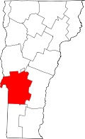 | |
| Towns | ||
| Village | ||
| CDPs | ||
| Other communities | ||