Rutland (city), Vermont
| City of Rutland | ||
| City | ||
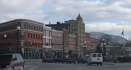 Downtown Historic District | ||
|
||
| Nickname: Marble City, Gateway to Southern Vermont | ||
| Country | United States | |
|---|---|---|
| State | Vermont | |
| County | Rutland | |
| Elevation | 541 ft (165 m) | |
| Coordinates | 43°36′32″N 72°58′47″W / 43.60889°N 72.97972°WCoordinates: 43°36′32″N 72°58′47″W / 43.60889°N 72.97972°W | |
| Area | 7.68 sq mi (19.89 km2) | |
| - land | 7.64 sq mi (20 km2) | |
| - water | 0.04 sq mi (0 km2), 0.52% | |
| Population | 16,495 (2010) | |
| Density | 2,147.8/sq mi (829.3/km2) | |
| Incorporated | 1892 | |
| Government | ||
| - coordinates | 42°46′28″N 73°41′59″W / 42.77444°N 73.69972°W | |
| Mayor | Christopher C. Louras (I) | |
| Timezone | EST (UTC-5) | |
| - summer (DST) | EDT (UTC-4) | |
| ZIP codes | 05701, 05702 | |
| Area code | 802 | |
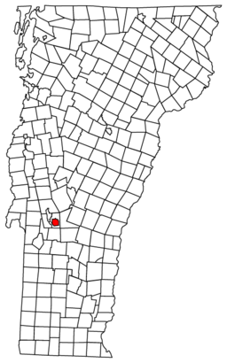 Rutland City, Vermont
| ||
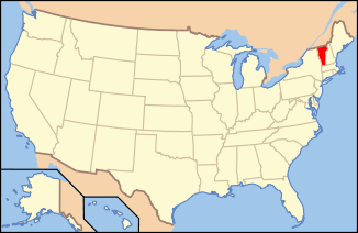 Location of Vermont in the United States
| ||
 Location in the United States | ||
| Website: http://www.rutlandcity.org/ | ||

The city of Rutland is the county seat[1][2] of Rutland County, Vermont, in the United States. As of the 2010 census, the city had a total population of 16,495.[3] Rutland is located approximately 65 miles (105 km) north of the Massachusetts state line and 20 miles (32 km) east of the state of New York. Rutland is the third largest city in Vermont, after Burlington and South Burlington. It is surrounded by the town of Rutland, which is a separate municipality. The downtown area of the city is listed as a historic district on the National Register of Historic Places.
History

It began on Otter Creek in the early 19th century as a small hamlet called Mill Village in Rutland, the surrounding town named by Governor Benning Wentworth in 1761 after John Manners, 3rd Duke of Rutland.[4] In the early 19th century, small high-quality marble deposits were discovered in Rutland, and in the 1830s a large deposit of nearly solid marble was found in what is now West Rutland. By the 1840s, small firms had begun excavations, but marble quarries proved profitable only after the railroad arrived in 1851. At the same time, the famous quarries of Carrara in Tuscany, Italy, grew largely unworkable because of their extreme depth, allowing Rutland to become one of the world's leading marble producers.[4]
This fueled enough growth and investment that in 1886 the center of town incorporated as Rutland village. Most of the town was split off as West Rutland and Proctor, which contained the bulk of the marble quarries. Rutland City was incorporated as Vermont's third city on November 18, 1892. The new city's first mayor was John A. Mead, who served only one term in 1893.[5]
In 1894, the nation's first polio outbreak was identified in the Rutland area. 132 people from the Rutland area were affected. Seven died. 110 others suffered some paralysis for life. 55 were from the city itself.[6]
In 1903, a Rutland City ordinance restricting the carrying of firearms led to the Vermont Supreme Court's decision in State v. Rosenthal, thereby establishing protection for the carrying of firearms without permit or license, what has become known as "Vermont Carry".[7] Nonetheless, Rutland had a similar ordinance in place as late as 1998,[8] at which point it was challenged and eventually removed, and there have been reports from residents of police harassment over openly carrying firearms as recently as June 2008.[9]
The closing of the marble quarries in the area in the 1980s and 1990s led to a loss of jobs in the area.
Geography
Rutland is located at 43°36′32″N 72°58′47″W / 43.60889°N 72.97972°W (43.60889, −72.97972).[10]
According to the United States Census Bureau, the city has a total area of 7.67 square miles (19.9 km2), of which 7.6 square miles (20 km2) is land and 0.04 square miles (0.10 km2), or 0.52%, is water. Rutland is drained by Otter Creek, Moon Brook, Tenney Brook, East Creek and Mussey Brook.
Climate
The city of Rutland has a humid continental climate (Köppen Dfb) with cold, snowy winters and warm to hot, moist summers. The all-time record high is 102, set in 2008. The all-time record low temperature is -43, set in 1994. On average, the wettest month is July, and February is the driest.
| Climate data for Rutland, Vermont | |||||||||||||
|---|---|---|---|---|---|---|---|---|---|---|---|---|---|
| Month | Jan | Feb | Mar | Apr | May | Jun | Jul | Aug | Sep | Oct | Nov | Dec | Year |
| Record high °F (°C) | 70 (21) |
67 (19) |
86 (30) |
92 (33) |
93 (34) |
95 (35) |
102 (39) |
98 (37) |
92 (33) |
86 (30) |
79 (26) |
69 (21) |
102 (39) |
| Average high °F (°C) | 29 (−2) |
32 (0) |
42 (6) |
56 (13) |
68 (20) |
76 (24) |
80 (27) |
78 (26) |
69 (21) |
58 (14) |
46 (8) |
34 (1) |
56 (13) |
| Average low °F (°C) | 8 (−13) |
10 (−12) |
19 (−7) |
32 (0) |
42 (6) |
52 (11) |
57 (14) |
55 (13) |
46 (8) |
35 (2) |
27 (−3) |
16 (−9) |
33 (1) |
| Record low °F (°C) | −43 (−42) |
−26 (−32) |
−20 (−29) |
5 (−15) |
24 (−4) |
32 (0) |
39 (4) |
33 (1) |
24 (−4) |
16 (−9) |
−1 (−18) |
−23 (−31) |
−43 (−42) |
| Average precipitation inches (mm) | 2.54 (64.5) |
2.25 (57.2) |
2.77 (70.4) |
2.88 (73.2) |
3.70 (94) |
3.97 (100.8) |
4.76 (120.9) |
4.07 (103.4) |
3.71 (94.2) |
3.83 (97.3) |
3.27 (83.1) |
2.80 (71.1) |
41.18 (1,046) |
| Source: The Weather Channel[11] | |||||||||||||
Transportation
Roads and highways
Rutland is the largest city in Vermont that is not located on, or near, either of the state's two major Interstate highways. It is, however, signed on I-91 at exit 6 northbound, and on I-89 at exits 13 and 3 southbound and exit 1 northbound. In addition, the city appears on auxiliary guide signs on the Adirondack Northway (I-87) before Exits 17 and 20.
U.S. Route 4 and U.S. Route 7 intersect and overlap each other in Rutland along Main Street between the Diamond Run Mall and Woodstock Avenue and are the two main routes into the city. U.S. 7 connects Rutland with Manchester and Bennington to the south, and with Middlebury and Burlington to the north. To the east, U.S. 4 travels through Killington, Woodstock and White River Junction on its way toward New Hampshire. To the west, U.S. 4 has been rebuilt as a 4-lane freeway to the New York state line, a distance of just over 18 miles (29 km). It is currently the only limited-access freeway to serve Rutland. The former route of U.S. 4, which runs parallel to the freeway portion, is now signed as US Route 4 Business and Vermont Route 4A.
Rail

Rutland's railroad station is the terminal station for Amtrak's Ethan Allen Express, which provides daily 5.5 hour service to and from New York City.[12] In January, 2013 Vermont Governor Peter Shumlin proposed extending the Ethan Allen Express from Rutland to Burlington, Vermont, the state's largest city. The proposal would create a regional rail corridor connecting Albany, Saratoga Springs, Rutland and Burlington and their combined metro populations of around 1.25 million inhabitants.[13]
Bus
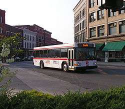
Rutland is home to "The Bus", run by Marble Valley Regional Transit District, a local bus system costing $0.50 per person per ride ($0.25 for discount qualified riders), and $1–2 for out-of-town commuter and connector buses, with other expenses covered largely by taxpayers. Five local routes currently serve the city, along with other commuter routes serving the nearby towns of Fair Haven, Manchester, Middlebury (in a partnership with Addison County Transit Resources), and Proctor. 2 winter tourist geared buses also go to and from Okemo Mountain in Ludlow and Killington Ski Resort; the bus serving Killington is called the Diamond Express. Both of these buses run year round. "The Bus" was free prior to 2007, when the 50 cents fare was added to control the added gas expenses. MVRTD is housed in the downtown Marble Valley Regional Transit Center.
Premier Coach's Vermont Translines serves Rutland daily with two intercity bus connections between Burlington, Lebanon, New Hampshire and Albany, New York, in its partnership with Greyhound. The two bus lines also meet at the Marble Valley Regional Transit Center as of June 9, 2014.[14][15]
Air
The Rutland Southern Vermont Regional Airport is located just south of the city, in North Clarendon. The airport offers daily flights to Boston operated by Cape Air.
Demographics
| Historical population | |||
|---|---|---|---|
| Census | Pop. | %± | |
| 1880 | 7,502 | — | |
| 1890 | 8,239 | 9.8% | |
| 1900 | 11,499 | 39.6% | |
| 1910 | 13,546 | 17.8% | |
| 1920 | 14,954 | 10.4% | |
| 1930 | 17,315 | 15.8% | |
| 1940 | 17,082 | −1.3% | |
| 1950 | 17,659 | 3.4% | |
| 1960 | 18,325 | 3.8% | |
| 1970 | 19,293 | 5.3% | |
| 1980 | 18,436 | −4.4% | |
| 1990 | 18,230 | −1.1% | |
| 2000 | 17,292 | −5.1% | |
| 2010 | 16,495 | −4.6% | |
| Est. 2015 | 15,824 | [16] | −4.1% |
| U.S. Decennial Census[17] | |||
As of the census[18] of 2010, there were 16,495 people, 7,167 households, and 4,209 families residing in the city. The population density was 2254.5 people per square mile (870.3/km2). There were 7,167 housing units at an average density of 94.49/sq mi (289.0/km2). The racial makeup of the city was 95.9% White, 0.8% African American, 0.3% Native American, 0.8% Asian, 0.1% Pacific Islander, 0.3% from other races, and 1.8% from two or more races. Hispanic or Latino of any race were 1.5% of the population.
There were 7,452 households out of which 21.1% had children under the age of 18 living with them, 39.8% were married couples living together, 12.5% had a female householder with no husband present, and 43.5% were non-families. 36.1% of all households were made up of individuals and 13.9% had someone living alone who was 65 years of age or older. The average household size was 2.22 and the average family size was 2.80.
In the city the population was spread out with 22.7% under the age of 18, 7.8% from 18 to 24, 28.9% from 25 to 44, 22.4% from 45 to 64, and 18.2% who were 65 years of age or older. The median age was 39.3 years. For every 100 females there were 89.8 males. For every 100 females age 18 and over, there were 86.5 males.
Government
At the local level, Rutland is governed by a Mayor and Board of Aldermen.[19] For representation in the Vermont House of Representatives, Rutland is split into four districts.[20] In the Vermont Senate, Rutland is represented by three state senators who serve most of Rutland County.[21]
Economy
Sales
One measure of economic activity is retail sales. Rutland stood third in the state in 2007 with $321.6 million.[22]
Personal income
The median income for a household in the city was $30,478, and the median income for a family was $41,561. Males had a median income of $29,457 versus $23,688 for females. The per capita income for the city was $17,075. 15.4% of the population and 10.3% of families were below the poverty line. Out of the total people living in poverty, 30.1% are under the age of 18 and 10.5% are 65 or older.
Industry
Major area employers are Rutland Regional Medical Center, General Electric Aircraft Engines (GE), OMYA, Green Mountain Power and Carris Reels. GE employed 975 workers in 2010.[23] Casella Waste Systems is the second largest private employer (behind GE Aircraft), employing 583 employees at its headquarters on Green Hill Lane.[24]
Hospital
Rutland Regional Medical Center is Vermont's second-largest health care facility,[25] with 188 inpatient beds and 120 physicians.
Downtown Rutland
Five businesses have opened in downtown Rutland since September 2013, including Small Dog Electronics (aided by a partnership with Green Mountain Power),[26] The Bakery,[27] Cape Air,[28] Raw Honey Apparel[29] Yogurt City,[30] and Hop'n Moose Brewing,[31] a brewpub that will be brewing hand-crafted beer. A corner in Downtown Rutland was also described in a 2014 article describing the city's embedded heroin trade.[32]
Culture
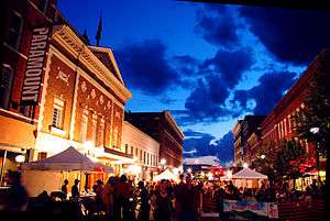
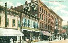
The downtown section contains the Rutland Free Library,[33] the Paramount Theater[34] and Merchant's Row, a restored street dating back to the mid-19th century. 108 buildings in downtown Rutland are listed in the National Register of Historic Places. Rutland also has the 275-acre (111 ha) Pine Hill Park[35] offering mountain biking, hiking, and other outdoor recreation. At the park's entrance is the Flip Side Skatepark,[36] municipally operated in an open-sided closed roof arena at the Giorgetti Athletic Complex.
Events in Rutland
- Art in the Park
- Friday Night Live
- The Ethnic Festival
- A Summer Farmers' Market in downtown Rutland's Depot Park
- A Winter Farmers' Market in the Vermont Farmers Food Center
- The Summer Concert Series
- Red Knights International Firefighters Motorcycle Club (in 2013)
- The Vermont State Fair
The Rutland Halloween Parade has taken place annually since 1960. In the early 1970s, the Rutland Halloween Parade was used as the setting of a number of superhero comic books, including Batman #237, Justice League of America #103, Freedom Fighters #6, Amazing Adventures #16, Avengers #83, and The Mighty Thor #207. The parade celebrated its 50th anniversary in 2009.[37]
In popular culture
Some episodes of the truTV reality show Speeders feature the Rutland City Police Department.[38]
Sister city
Since 1986, Rutland hosts an annual exchange called the Rutland Ishidoriya Student Exchange (R.I.S.E), selecting students from grades 8-11 to send to Ishidoriya, Japan. All of the money used to support the exchange is from fundraising. In exchange, 5 students from Ishidoriya come to Rutland the January after the Rutland ambassadors return each year.
Historic sites
(Date indicates inclusion on the National Register of Historic Places)
- Arthur Perkins House — 242 South Main Street (added October 27, 1988)
- Chaffee-Moloney Houses — 194 & 196-98 Columbian Avenue (added December 19, 2001)
- Clementwood — Clement Road (added October 27, 1980)
- H. H. Baxter Memorial Library — 96 Grove Street (added September 24, 1978)
- Longfellow School — 6 Church Street (added 1976)
- Proctor-Clement House — 85 Field Avenue (added July 17, 1982)
- Rutland Courthouse Historic District — U.S. 7 (added October 8, 1976)
- Rutland Downtown Historic District — roughly bounded by Strong Avenue, State, Wales, Washington, Pine and Cottage streets (added September 22, 1980)
- Rutland Free Library, the 1859 former post office and courthouse designed by Ammi B. Young
- St. Peter's Church and Mount St. Joseph Convent Complex — Convent Avenue, Meadow and River streets (added November 3, 1980)
Education

Public
Public schools are managed by Rutland City Public Schools. These are:
- Rutland High School
- Rutland Middle School
- Allen Street Campus
- Howe Center Campus
- Rutland Intermediate School
- Northwest Primary School
- Northeast Primary School
- Stafford Technical Center
A publicly funded pre-kindergarten program for eligible families is offered through Rutland County Head Start on Meadow Street.[39]
Private
Private schools include the Catholic Christ the King School (primary) and Mount Saint Joseph Academy (9-12), and the Rutland Area Christian School (K-12). Private pre-kindergarten programs are offered at Grace Preschool,[40] Hearts and Minds Childcare and Preschool, Good Shepherd's Little Lambs Early Learning Center, The Peanut Gallery Preschool & Early Learning Center, and more.[41]
College
The city is also home to two colleges, The College of St. Joseph in Vermont (formerly called College of Saint Joseph the Provider), and Community College of Vermont (CCV). Many Rutland residents will commute to nearby Castleton University, whose hockey teams practice in nearby Rutland (town), Vermont.
Media
Newspapers
The city's print news comes from the Pulitzer Prize-winning[42] daily Rutland Herald. The weekly newspapers "Green Mountain Outlook" and the "Rutland Reader"[43] are also published in Rutland. "The Mountain Times" is also widely circulated in Rutland.
Radio
There are seven radio stations licensed to Rutland:
- 88.7 FM WRVT (public radio)
- 90.9 WFTF
- 94.5 WDVT (classic hits)
- 97.1 WZRT (Top 40)
- 98.1 WJJR (Adult Contemporary hits)
- 105.3 WJEN (country music)
- 1380 AM WSYB
Television
Rutland is part of the Burlington / Plattsburgh television market. Comcast offers most major in-market channels, including local Vermont PBS outlet WVER, channel 28, as well as Albany, New York stations WRGB (CBS), WTEN (ABC), and WMHT (PBS).[44] PEGTV[45] broadcasts local government programming on Comcast channels 15, 20, and 21.

Notable people
See also
- Rutland City School District
- Rutland Railway
- Rutland (Amtrak station)
- List of Rutland, Vermont Mayors
References
- ↑ "Find a County". National Association of Counties. Retrieved 2011-06-07.
- ↑ Title 24, Part I, Chapter 1, §12, Vermont Statutes. Accessed November 1, 2007.
- ↑ "Race, Hispanic or Latino, Age, and Housing Occupancy: 2010 Census Redistricting Data (Public Law 94-171) Summary File (QT-PL), Rutland city, Vermont". U.S. Census Bureau, American FactFinder 2. Retrieved November 1, 2011.
- 1 2 A. J. Coolidge & J. B. Mansfield, A History and Description of New England; Boston, Massachusetts 1859
- ↑ 109th Annual Report Fiscal Year July 1, 2000 to June 30, 2001 City of Rutland, Vermont
- ↑ Remsen, Nancy (September 29, 2007). Polio marker moved to public spot. Burlington Free Press.
- ↑ "State V. Rosenthal". Guncite.com. 1903-05-30. Retrieved 2016-01-05.
- ↑ "Vermonters for Liberty :: Vermont Libertarians". Vtlp.org. Retrieved 2016-01-05.
- ↑ Archived June 13, 2008, at the Wayback Machine.
- ↑ "US Gazetteer files: 2010, 2000, and 1990". United States Census Bureau. 2011-02-12. Retrieved 2011-04-23.
- ↑ "Climate Statistics for Rutland, Vermont". Retrieved January 4, 2014.
- ↑ "Ethan Allen Express - the Train from Albany to NYC and Rutland". Amtrak. 2015-08-27. Retrieved 2016-01-05.
- ↑ "Vermont governor seeks more Amtrak service". Railway Age. 2013-01-31. Retrieved 2016-01-05.
- ↑ Christine Souders. "New Vermont Bus Service Coming Soon - Story". MyChamplainValley.com. Retrieved 2016-01-05.
- ↑ "Vermont Bus Schedules". Vttranslines.com. Retrieved 2016-01-05.
- ↑ "Annual Estimates of the Resident Population for Incorporated Places: April 1, 2010 to July 1, 2014". Retrieved June 4, 2015.
- ↑ "U.S. Decennial Census". United States Census Bureau. Retrieved May 16, 2015.
- ↑ "American FactFinder". United States Census Bureau. Retrieved 2016-06-12.
- ↑ "City of Rutland, Vermont". Rutlandcity.org. 2015-03-03. Retrieved 2016-01-05.
- ↑ "The Vermont Legislative Bill Tracking System". Leg.state.vt.us. Retrieved 2016-01-05.
- ↑ "District: RUT" (PDF). Leg.state.vt.us. Retrieved 2016-01-05.
- ↑ McLean, Dan (July 13, 2008). Retail Sales by the numbers. Burlington Free Press.
- ↑ Briggs, John (23 August 2010). "Sky's the limit". Burlington, Vermont: Burlington Free Press. pp. 1B,12B.
- ↑ "REDC Major Employers". Rutland Economic Development Corporation. Retrieved 17 April 2011.
- ↑ "Rutland Regional Medical Center". Vermont.com. Retrieved 2016-01-05.
- ↑ "Small Dog Electronics Announces New Retail Location in Rutland". Prweb.com. 2012-09-06. Retrieved 2016-01-05.
- ↑ Palmer, Hannah. "A Locavore Bakery Opens in Rutland | Food News | Seven Days | Vermont's Independent Voice". Sevendaysvt.com. Retrieved 2016-01-05.
- ↑ "Cape Air opens office in downtown Rutland | Vermont Business Magazine". Vermontbiz.com. 2014-01-06. Retrieved 2016-01-05.
- ↑ "New Rutland businesses emerge downtown : Rutland Herald Online". Rutlandherald.com. 2013-10-27. Retrieved 2016-01-05.
- ↑ "FroYo a go-go: Yogurt City opens in Rutland". Rutland Reader. 2013-11-13. Retrieved 2016-01-05.
- ↑ "Rutland's first brewpub plans April opening". Timesargus.com. 2014-01-14. Retrieved 2016-01-05.
- ↑ "A Call to Arms on a Vermont Heroin Epidemic". The New York Times. Retrieved 2016-01-05.
- ↑ "Rutland Free Library". Rutlandfree.org. 1999-09-30. Retrieved 2016-01-05.
- ↑ Vermont. "Paramount Theatre | Rutland, Vermont". Paramountvt.org. Retrieved 2016-01-05.
- ↑ "Pine Hill Park" (PDF). Pinehillpark.org. Retrieved 2016-01-05.
- ↑ "Flip Side Skatepark in Rutland, VT 2015 Season". FlipSidePark.com. 2009-04-26. Retrieved 2016-01-05.
- ↑ "Rutland scares up pride with 50-year Halloween Parade : Rutland Herald Online". Rutlandherald.com. Retrieved 2016-01-05.
- ↑ Archived July 7, 2013, at the Wayback Machine.
- ↑ "About Rutland County Head Start". Rchsccn.org. Retrieved 2016-01-05.
- ↑ "Grace Preschool | Rutland, VT Preschool". Gracepreschoolvt.com. 2015-02-09. Retrieved 2016-01-05.
- ↑ Archived November 14, 2012, at the Wayback Machine.
- ↑ "Rutland Herald". Rutland Herald. Retrieved 2016-01-05.
- ↑ Minichiello, Patricia. "Rutland Reader". Rutland Reader. Retrieved 2016-01-05.
- ↑ "TV Listings, TV Show Guide, Entertainment News, TV Ratings". Zap2It. Retrieved 2016-01-05.
- ↑ "Rutland Region Community Television 15, 20, 21". PEGTV. Retrieved 2016-01-05.
Further reading
- Federal Writers’ Project (1937). "Rutland". Vermont: a Guide to the Green Mountain State. American Guide Series. Cambridge, Massachusetts: Riverside Press – via Internet Archive.
External links
| Wikisource has the text of a 1920 Encyclopedia Americana article about Rutland, Vermont. |
Municipalities and communities of Rutland County, Vermont, United States | ||
|---|---|---|
| City | 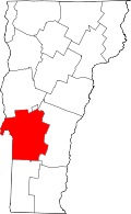 | |
| Towns | ||
| Village | ||
| CDPs | ||
| Other communities | ||
Montpelier (capital) | |
| Regions | |
| Counties | |
| Cities | |
| Towns (pop. >5000) | |
| Festivals | |
| Topics |
|
| Society |
|