Chickies Historic District
|
Chickies Historic District | |
|
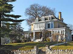
House in Chickies Historic District, February 2012 | |
  | |
| Location | Roughly bounded by the Susquehanna R, Chickies Creek, Bank St. and Long Lane., East Donegal Township, West Hempfield Township, and Marietta, Pennsylvania |
|---|---|
| Coordinates | 40°03′27″N 76°33′28″W / 40.05750°N 76.55778°WCoordinates: 40°03′27″N 76°33′28″W / 40.05750°N 76.55778°W |
| Area | 589 acres (238 ha) |
| Architectural style | Early Republic, Late Victorian |
| NRHP Reference # | 05001488[1] |
| Added to NRHP | December 28, 2005 |
Chickies Historic District is a national historic district located at East Donegal Township, West Hempfield Township, and Marietta, Lancaster County, Pennsylvania. The district includes 32 contributing buildings, 16 contributing sites, and 4 contributing structures in three areas. They are: 1) floodplain along the Susquehanna River containing archaeological remains of iron furnaces; 2) the "Ironmasters' Hill" area of Marietta with five residences associated with ironmasters (c. 1848-1876); and 3) the Donegal Creek area with farmland, iron pits, and limestone quarries owned by the ironmasters.[2]
It was listed on the National Register of Historic Places in 2005.[1]
References
- 1 2 National Park Service (2010-07-09). "National Register Information System". National Register of Historic Places. National Park Service.
- ↑ "National Historic Landmarks & National Register of Historic Places in Pennsylvania" (Searchable database). CRGIS: Cultural Resources Geographic Information System. Note: This includes Margaret Hunt Landis and James Clarkson Landis (March 2005). "National Register of Historic Places Inventory Nomination Form: Chickies Historic District" (PDF). Retrieved 2012-02-23.
| Topics |   | |
|---|---|---|
| Lists by county |
| |
| Lists by city | ||
| Other lists | ||
| ||
This article is issued from Wikipedia - version of the 11/29/2016. The text is available under the Creative Commons Attribution/Share Alike but additional terms may apply for the media files.