Cedartown, Georgia
| Cedartown, Georgia | |
|---|---|
| City | |
|
Downtown Cedartown | |
 Location in Polk County and the state of Georgia | |
| Coordinates: 34°0′55″N 85°15′14″W / 34.01528°N 85.25389°WCoordinates: 34°0′55″N 85°15′14″W / 34.01528°N 85.25389°W | |
| Country | United States |
| State | Georgia |
| County | Polk |
| Government | |
| • Type | City Commission |
| Area | |
| • Total | 6.8 sq mi (17.8 km2) |
| • Land | 6.8 sq mi (17.7 km2) |
| • Water | 0 sq mi (0.1 km2) |
| Elevation | 840 ft (260 m) |
| Population (2010) | |
| • Total | 9,750 |
| • Density | 1,400/sq mi (550/km2) |
| Time zone | Eastern (EST) (UTC-5) |
| • Summer (DST) | EDT (UTC-4) |
| ZIP code | 30125 |
| Area code(s) | 770/678/470 |
| FIPS code | 13-14500[1] |
| GNIS feature ID | 0312503[2] |
| Website | Cedartown, Georgia |

Cedartown is a city in Polk County, Georgia. As of the 2010 census, the city had a population of 9,750.[3] The city is the county seat of Polk County.[4] Cedartown is the principal city of and is included in the Cedartown, Georgia Micropolitan Statistical Area, which is included in the Atlanta-Sandy Springs-Gainesville, Georgia-Alabama (part) Combined Statistical Area.
The Cedartown Commercial Historic District is listed on the National Register of Historic Places. The Cedartown Waterworks-Woman's Building-Big Spring Park Historic District is also listed along with the Northwest Cedartown Historic District and South Philpot Street Historic District.
Geography
According to the United States Census Bureau, Cedartown has a total area of 6.9 square miles (18 km2), of which 6.8 square miles (18 km2) is land and 0.04 square miles (0.10 km2) (0.44%) is water.
History

Cherokee and Creek Native Americans first inhabited the area known as Cedar Valley. The Cherokee people had established a village there in the 1830s after the Native Americans were forced out on the Trail of Tears.[5]
The most famous of these settlers was Asa Prior. According to local legend, the water rights to Big Spring were won for the white settlers by a local white boy in a footrace with a Cherokee youth. Some versions of the legend differ, saying that the rights to the spring were won by the Cherokee people from the Creek people in a ball game. "Big Strickland" became "Cedar Town" when Prior deeded ten acres of adjacent land to the newly chartered city in 1852. Big Strickland was the original county seat and Cedar Town became the county seat later.
During the Civil War, Cedar Town was abandoned by most of its citizens when Union troops encroached. The city was burnt to the ground by the Union forces of General Hugh Judson Kilpatrick in 1865, leaving only one mill standing on the outskirts of town.
In 1867, the town was re-chartered by the state of Georgia as Cedartown. An influx of industrial business bolstered its largely cotton-based economy, with Goodyear and other fabric mills and iron works appearing in or near what is now the Cedartown Industrial Park on the west side of town.
Industrial and passenger railroad service was added to Cedartown in the early 20th century. Main St. became a part of U.S. Route 27, a major north-south automobile route that connects Cedartown to larger cities like Chattanooga, Tennessee and Columbus, Georgia. U.S. 27 also intersects in town with U.S. Route 278, which connects Cedartown with Atlanta.
The Goodyear Tire and Rubber Company built a large textile mill operation in Cedartown, and also built a large residential section of town for mill workers, now known as the Goodyear Village.
In recent times, the Georgia Rails to Trails project has converted much of the former Seaboard Air Line into the Silver Comet Trail, a federal and state funded park that connects many cities in northwest Georgia.
Cedartown's Main Street is listed in the National Register of Historic Places in recognition of its 1890s architecture. During the 1970s, many structures were demolished, including train stations, churches, and a high school, and a theater on Main Street.
Downtown Cedartown has recently seen massive investment in new sidewalks, street parks, and paving to showcase the downtown district.
Arts and culture
- Cedartown Performing Arts Center
Sites on the National Register of Historic Places:
- Cedartown Commercial Historic District
- Cedartown Waterworks-Women's Building-Big Spring Park Historic District
- Hawkes Children's Library
- Northwest Cedartown Historic District
Demographics
| Historical population | |||
|---|---|---|---|
| Census | Pop. | %± | |
| 1870 | 323 | — | |
| 1880 | 843 | 161.0% | |
| 1890 | 1,625 | 92.8% | |
| 1900 | 2,823 | 73.7% | |
| 1910 | 3,551 | 25.8% | |
| 1920 | 4,053 | 14.1% | |
| 1930 | 8,124 | 100.4% | |
| 1940 | 9,025 | 11.1% | |
| 1950 | 9,470 | 4.9% | |
| 1960 | 9,340 | −1.4% | |
| 1970 | 9,253 | −0.9% | |
| 1980 | 8,619 | −6.9% | |
| 1990 | 7,978 | −7.4% | |
| 2000 | 9,470 | 18.7% | |
| 2010 | 9,750 | 3.0% | |
| Est. 2015 | 9,841 | [6] | 0.9% |
As of the census[1] of 2000, there were 9,470 people, 3,370 households, and 2,237 families residing in the city. The population density was 1,384.0 people per square mile (534.6/km²). There were 3,642 housing units at an average density of 532.2 per square mile (205.6/km²). The racial makeup of the city was 63.37% White, 20.20% African American, 0.21% Native American, 0.37% Asian, 0.12% Pacific Islander, 14.13% from other races, and 1.61% from two or more races. Hispanic or Latino of any race were 22.62% of the population.
There were 3,370 households out of which 29.4% had children under the age of 18 living with them, 43.1% were married couples living together, 17.6% had a female householder with no husband present, and 33.6% were non-families. 29.5% of all households were made up of individuals and 15.2% had someone living alone who was 65 years of age or older. The average household size was 2.65 and the average family size was 3.18.
In the city the population was spread out with 25.1% under the age of 18, 13.2% from 18 to 24, 27.1% from 25 to 44, 18.2% from 45 to 64, and 16.5% who were 65 years of age or older. The median age was 32 years. For every 100 females there were 102.9 males. For every 100 females age 18 and over, there were 99.9 males.
The median income for a household in the city was $24,562, and the median income for a family was $28,119. Males had a median income of $25,295 versus $20,711 for females. The per capita income for the city was $12,251. About 20.3% of families and 24.3% of the population were below the poverty line, including 28.7% of those under age 18 and 15.3% of those age 65 or over.
Education
Polk County School District
The Polk County School District holds pre-school to grade twelve, and consists of six elementary schools, two middle schools, and two high schools.[8] The district has 449 full-time teachers and over 7,017 students.[9]
Transportation and economy

With the shift away from rural living patterns and toward interstate highway satellite suburban living patterns, combined with the general U.S. shift away from agricultural and industrial economies, Cedartown is left in an awkward position. The city suffered a major economic blow when the Goodyear Tire and Rubber Company closed its local mill operations. For its employment, Cedartown mainly relies on the prospect of large corporate operation centers such as Cingular Wireless, manufacturing operations like that of The HON Company, and the retail operations of Wal-Mart.
The Hon Company is Cedartown's largest for-profit employer with over 800 employees. With a recently announced expansion, this number will grow in the near future. Cedartown is also home to an AT&T (formerly Cingular) technical support facility for the company's wireless customers.
The Rome Plow Company, formerly located in Rome, Georgia, is headquartered in Cedartown. It manufactured the Rome plows used as jungle-clearing vehicles during the Vietnam War and produced agricultural vehicles until it shut down in late 2009. Rome Plow has since been purchased and re-opened. The new facility recently underwent an expansion.
Access to nearby major cities such as Atlanta, Birmingham, and Chattanooga is easier with the expansion of U.S. Highway 27, which is four lanes from I-20 into Cedartown. The four lane expansion will soon have U.S. 27 fourlaned all the way north to the Tennessee state line.
Passenger rail service to Cedartown was abandoned in the 1970s, leading to the destruction of the historic Cedartown Depot train station. The city built a replica of the historic depot which now serves as the Welcome Center and the trailhead to the Silver Comet Trail.
The city does offer bus service and has frequent routes to neighboring Rockmart. The nearest stop on the Greyhound line is a full service station in Rome, Georgia, 20 miles north.
The nearest major airport is Hartsfield-Jackson Atlanta International Airport in Atlanta, 70 miles southeast; several local shuttle services are available.
Popular culture
Country music artist Waylon Jennings had a minor hit single with the murder ballad "Cedartown, Georgia" from the 1971 album of the same name. The slow, meditative song about betrayal and murder was a portent of the outlaw country genre's predilection for themes that stood outside of what was acceptable in the Nashville music establishment:
Tonight I'll put her on a train for Georgia.
Gonna be a lot of kin folks squallin' and a-grievin',
'Cause that Cedartown gal ain't breathin'.
Media
Movie production
- Jayne Mansfield's Car (2012) is a drama movie featuring locations in Cedartown as a fictional city in Alabama. Visible is the historic downtown.
Notable people
- Ray Beck (1931-2007), All-American football player at Georgia Tech and professional football player
- Edgar Chandler (1946-1992), two-time All-American football player at the University of Georgia and professional player for the Buffalo Bills and New England Patriots
- Nick Chubb, University of Georgia football player.
- Betty Reynolds Cobb, an author and activist, was a native of Cedartown, Georgia. She was the first woman in Georgia to be admitted to the state bar.
- Phil Douglas (1890–1952), Major League Baseball player
- Agnes Ellen Harris, educator
- Seale Harris, physician and researcher, best known for his 1924 hypothesis of hyperinsulinism as a cause of spontaneous hypoglycemia
- Sterling Holloway was a legend of stage and screen with over 100 movies and television shows to his credit. He was well known for his distinctive tenor voice, and is best remembered as the voice of Walt Disney's Winnie the Pooh. Holloway was born and raised in Cedartown.
- Sam Hunt, country/hip-hop singer/songwriter and former college football player
- Doug Sanders, winner of twenty tournaments on the PGA Tour
Recreation
- Silver Comet Trail[10]
Images
-

The water tower on Central Street
-
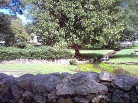
Big Spring Park
See also
References
- 1 2 "American FactFinder". United States Census Bureau. Archived from the original on 2013-09-11. Retrieved 2008-01-31.
- ↑ "US Board on Geographic Names". United States Geological Survey. 2007-10-25. Retrieved 2008-01-31.
- ↑ http://quickfacts.census.gov/qfd/states/13/1314500.html
- ↑ "Find a County". National Association of Counties. Archived from the original on 2011-05-31. Retrieved 2011-06-07.
- ↑ "Polk County". Calhoun Times. 1 September 2004. p. 98. Retrieved 26 April 2015.
- ↑ "Annual Estimates of the Resident Population for Incorporated Places: April 1, 2010 to July 1, 2015". Retrieved July 2, 2016.
- ↑ "Census of Population and Housing". Census.gov. Archived from the original on May 11, 2015. Retrieved June 4, 2015.
- ↑ Georgia Board of Education, Retrieved June 25, 2010.
- ↑ School Stats, Retrieved June 25, 2010.
- ↑ Silver Comet Trail, Cedartown Depot Trailhead Facts - Cedartown, GA
External links
Municipalities and communities of Polk County, Georgia, United States | ||
|---|---|---|
| Cities | 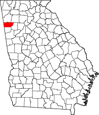 | |
| Town | ||
| Unincorporated communities | ||
| Footnotes | ‡This populated place also has portions in an adjacent county or counties | |