Braswell, Georgia
| Braswell, Georgia | |
|---|---|
| City | |
|
Braswell city hall | |
 Location in Paulding County and the state of Georgia | |
| Coordinates: 33°59′2″N 84°57′34″W / 33.98389°N 84.95944°WCoordinates: 33°59′2″N 84°57′34″W / 33.98389°N 84.95944°W | |
| Country | United States |
| State | Georgia |
| Counties | Polk, Paulding |
| Area | |
| • Total | 3.1 sq mi (7.9 km2) |
| • Land | 3.1 sq mi (7.9 km2) |
| • Water | 0 sq mi (0 km2) |
| Elevation | 1,161 ft (354 m) |
| Population (2010) | |
| • Total | 379 |
| • Density | 25.8/sq mi (10.1/km2) |
| Time zone | Eastern (EST) (UTC-5) |
| • Summer (DST) | EDT (UTC-4) |
| Area code(s) | 770/678/470 |
| FIPS code | 13-10104[1] |
| GNIS feature ID | 0331229[2] |

Braswell is a city in Polk and Paulding Counties in the U.S. state of Georgia. As of the 2010 census, the city had a population of 379.[3]
Geography
Braswell is located at 33°59′2″N 84°57′34″W / 33.98389°N 84.95944°W (33.983787, -84.959479).[4]
According to the United States Census Bureau, the city has a total area of 3.1 square miles (8.0 km2), of which, 3.1 square miles (8.0 km2) of it is land and 0.33% is water.
History
Braswell had a population of 25 in 1950. (Source=Columbia-Lippincott Gazeteer)
Braswell was the location of the only tunnel on Southern Railway's (now Norfolk Southern Railway) Chattanooga to Atlanta main line. The original tunnel was bypassed in 1979 by cutting through Braswell mountain slightly to the east. Another nearby tunnel, the Brushy Mountain tunnel at Divide, is currently used by bicyclists and joggers as a part of the Georgia/Alabama Silver Comet Trail.[5]
Demographics
| Historical population | |||
|---|---|---|---|
| Census | Pop. | %± | |
| 1900 | 100 | — | |
| 1910 | 95 | −5.0% | |
| 1920 | 58 | −38.9% | |
| 1930 | 76 | 31.0% | |
| 1940 | 56 | −26.3% | |
| 1950 | 25 | −55.4% | |
| 1960 | 14 | −44.0% | |
| 1970 | 30 | 114.3% | |
| 1980 | 282 | 840.0% | |
| 1990 | 247 | −12.4% | |
| 2000 | 80 | −67.6% | |
| 2010 | 379 | 373.8% | |
| Est. 2015 | 388 | [6] | 2.4% |
References
- ↑ "American FactFinder". United States Census Bureau. Archived from the original on 2013-09-11. Retrieved 2008-01-31.
- ↑ "US Board on Geographic Names". United States Geological Survey. 2007-10-25. Retrieved 2008-01-31.
- ↑ http://factfinder2.census.gov/faces/tableservices/jsf/pages/productview.xhtml?pid=DEC_10_SF1_GCTP2.ST13&prodType=table
- ↑ "US Gazetteer files: 2010, 2000, and 1990". United States Census Bureau. 2011-02-12. Retrieved 2011-04-23.
- ↑ "The Silver Comet Trail". Retrieved 2009-07-27.
- ↑ "Annual Estimates of the Resident Population for Incorporated Places: April 1, 2010 to July 1, 2015". Retrieved July 2, 2016.
- ↑ "Census of Population and Housing". Census.gov. Archived from the original on May 11, 2015. Retrieved June 4, 2015.
External links
Municipalities and communities of Paulding County, Georgia, United States | ||
|---|---|---|
| Cities | 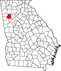 | |
| Unincorporated community | ||
| Footnotes | ‡This populated place also has portions in an adjacent county or counties | |
Municipalities and communities of Polk County, Georgia, United States | ||
|---|---|---|
| Cities | 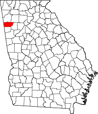 | |
| Town | ||
| Unincorporated communities | ||
| Footnotes | ‡This populated place also has portions in an adjacent county or counties | |