Buck Hill Farm Covered Bridge
| Buck Hill Farm Covered Bridge | |
| Abram Hess' Mill, Eichelberger's, Eichelberger's Stone | |
 | |
| Country | United States |
|---|---|
| State | Pennsylvania |
| County | Lancaster |
| Township | Warwick |
| Crosses | Farm pond inlet |
| Coordinates | 40°7′55.5″N 76°18′2.5″W / 40.132083°N 76.300694°WCoordinates: 40°7′55.5″N 76°18′2.5″W / 40.132083°N 76.300694°W |
| Length | 58 ft (18 m) |
| Width | 15 ft (5 m) |
| Design | Burr Arch Truss Bridge |
| Material | Wood |
| Built | ~1825 |
| - Reconstructed | 1844 |
| Owned and Maintained by | Private owner |
| WGCB Number | 38-36-15 |
| NRHP Ref Number | 80003528 |
| Added to NRHP | December 10, 1980 |
| MPS | Covered Bridges of Lancaster County TR |
 Location of the Buck Hill Farm Covered Bridge in Pennsylvania
| |
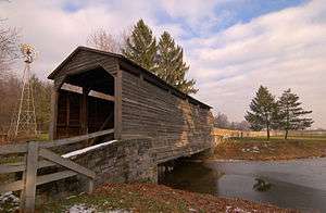
The Buck Hill Covered Bridge, Eichelberger's Covered Bridge, or Abram Hess' Mill Bridge is a covered bridge located in Lancaster County, Pennsylvania, United States. It is located on the Buck Hill Farm's pond on private property.[1][2]
The bridge's WGCB Number is 38-36-15.[1] In 1980 it was added to the National Register of Historic Places as structure number 80003528.[3] It is located on private property.[4]
The bridge is one of only 3 covered bridges in the county with horizontal side boards.
History
The original build date and builder of the covered bridge is unknown. However, it was probably built around 1825 to provide access to Abram Hess's store. In 1844 the bridge was sold to George Eichelberger. That same year the bridge was heavily damaged in a flood and had to be repaired.[2] It was rebuilt by Theodore D. Cochran at a cost of $799.[1][2][4] The bridge was moved, in 1966, to the Buck Hill Farm, a private farm located in Warwick Township 1.2 kilometers (0.75 mi) south of Kissel Hill on Pennsylvania Route 501.[2]
See also
- List of bridges on the National Register of Historic Places in Pennsylvania
- List of covered bridges in Lancaster County, Pennsylvania
- National Register of Historic Places listings in Lancaster County, Pennsylvania
References
- 1 2 3 Dr. Roger A. McCain. "Buck Hill Bridge". A Guide to Old Covered Bridges of Southeastern Pennsylvania and nearby areas. Retrieved 2006-08-03.
- 1 2 3 4 "Eichelberger's Covered Bridge". Lancaster County Pennsylvania Dutch Country Official Visitors Center. Pennsylvania Dutch Convention & Visitors Bureau. 2006. Retrieved 2006-07-07.
- ↑ "PENNSYLVANIA - Lancaster County". National Register of Historic Places. Retrieved 2007-03-20.
- 1 2 Travis, Dale. "38-36-15". Round Barns & Covered Bridges. Retrieved 2006-08-08.
| Topics |   | |
|---|---|---|
| Lists by county |
| |
| Lists by city | ||
| Other lists | ||
| ||