Bucher's Mill Covered Bridge
| Bucher's Mill Covered Bridge | |
| Butcher's Mill | |
 | |
| Official name: Cocalico #2 Bridge | |
| Country | United States |
|---|---|
| State | Pennsylvania |
| County | Lancaster |
| Township | East Cocalico |
| Road | T 955 (single lane) |
| Crosses | Cocalico Creek |
| Coordinates | 40°12′29″N 76°8′5″W / 40.20806°N 76.13472°WCoordinates: 40°12′29″N 76°8′5″W / 40.20806°N 76.13472°W |
| Length | 73 ft (22 m) |
| - Mainspan | 55 m (180 ft) [1] |
| Width | 15 ft (5 m) [2] |
| - Road width | 13 ft (4 m) [1] |
| Overhead Clearance | 11.5 ft (4 m) |
| Builder | Elias McMellen |
| Design | Burr Arch Truss Bridge |
| Material | Wood |
| Built | 1891 |
| - Reconstructed | 1997 |
| Owned and Maintained by | Lancaster County |
| NBI Number | 367210085505020 |
| WGCB Number | 38-36-12 |
| NRHP Ref Number | 80003514 |
| Load | 4 short tons (3.6 t) |
| Added to NRHP | December 11, 1980 |
| MPS | Covered Bridges of Lancaster County TR |
 Location of Bucher's Mill Covered Bridge in Pennsylvania
| |
| Wikimedia Commons: Bucher's Mill Covered Bridge | |
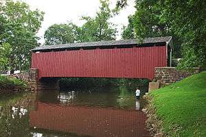
The Bucher's Mill Covered Bridge or Butcher's Mill Covered Bridge is a covered bridge that spans Cocalico Creek in Lancaster County, Pennsylvania, United States. After the Landis Mill Covered Bridge, it is the second shortest covered bridge in the county.[3] A county-owned and maintained bridge, its official designation is the Cocalico #2 Bridge.
The bridge has a single span, wooden, double Burr arch trusses design with the addition of steel hanger rods. The deck is made from oak planks.[4] It is painted red, the traditional color of Lancaster County covered bridges, on both the inside and outside. Both approaches to the bridge are painted in the traditional white color.
The bridge's WGCB Number is 38-36-12. In 1980 it was added to the National Register of Historic Places as structure number 80003514.[5] It is located at 40°12′28.2″N 76°8′4.8″W / 40.207833°N 76.134667°W (40.20783, -76.134667)[6] to the northeast of Ephrata, Pennsylvania off Pennsylvania Route 272 on Cocalico Creek Road.
History
The Bucher's Mill Covered Bridge was built in 1891Note: [7] by Elias McMellen, using single span, wooden, double Burr arch truss construction, at a cost of $1167. A year later, in 1892, the bridge was damaged heavily in a flood and was rebuilt by McMellen for $1025.[3]
See also
- List of bridges on the National Register of Historic Places in Pennsylvania
- List of covered bridges in Lancaster County, Pennsylvania
- National Register of Historic Places listings in Lancaster County, Pennsylvania
References
- 1 2 Federal Highway Administration National Bridge Inventory (2009). "Place Name: East Cocalico (Township of), Pennsylvania; NBI Structure Number: 367210085505020; Facility Carried: Cocalico Creek Rd; Feature Intersected: Cocalico Creek". Nationalbridges.com (Alexander Svirsky). Retrieved August 26, 2009. Note: this is a formatted scrape of the 2006 official website, which can be found here for Pennsylvania: "PA06.txt". Federal Highway Administration. 2006. Retrieved August 26, 2009.
- ↑ McCain, Roger A. "Butcher's Mill Bridge". A Guide to Old Covered Bridges of Southeastern Pennsylvania and nearby areas. Retrieved August 3, 2006.
- 1 2 "Bucher's Mill Covered Bridge". Lancaster County Pennsylvania Dutch Country Official Visitors Center. Pennsylvania Dutch Convention & Visitors Bureau. 2006. Retrieved 2006-07-07.
- ↑ "Bucher's Mill Covered Bridge". Lancaster County, PA Government Portal. County of Lancaster, Pennsylvania. 2001-10-20. Retrieved 2006-07-07.
- ↑ "PENNSYLVANIA - Lancaster County". National Register of Historic Places. Retrieved 2007-03-20.
- ↑ Travis, Dale. "38-36-12". Round Barns & Covered Bridges. Retrieved 2006-08-08.
- ↑ Note: McCain lists a build date of 1892.
| Topics |   | |
|---|---|---|
| Lists by county |
| |
| Lists by city | ||
| Other lists | ||
| ||