Brownsville, Wisconsin
| Brownsville, Wisconsin | |
|---|---|
| Village | |
|
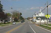
Looking east in Brownsville on Wisconsin Highway 49 | |
 Location of Brownsville, Wisconsin | |
| Coordinates: 43°37′1″N 88°29′28″W / 43.61694°N 88.49111°WCoordinates: 43°37′1″N 88°29′28″W / 43.61694°N 88.49111°W | |
| Country | United States |
| State | Wisconsin |
| County | Dodge |
| Area[1] | |
| • Total | 0.52 sq mi (1.35 km2) |
| • Land | 0.52 sq mi (1.35 km2) |
| • Water | 0 sq mi (0 km2) |
| Elevation[2] | 997 ft (304 m) |
| Population (2010)[3] | |
| • Total | 581 |
| • Estimate (2012[4]) | 580 |
| • Density | 1,117.3/sq mi (431.4/km2) |
| Time zone | Central (CST) (UTC-6) |
| • Summer (DST) | CDT (UTC-5) |
| FIPS code | 55-10450[5] |
| GNIS feature ID | 1562277[2] |
| Website |
www |
Brownsville is a village in Dodge County, Wisconsin, United States. The population was 581 at the 2010 census.
History
Brownsville was founded around 1878. It originally had a canning factory at the corner of West Avenue and Main Street where Michels Corporation exists today. The village was first known as Thetis Station and had a narrow gauge railroad connection to Fond du Lac and Iron Ridge. The Lutheran church was located next to the cemetery.
Geography

Brownsville is located at 43°37′1″N 88°29′28″W / 43.61694°N 88.49111°W (43.617063, -88.491134),[6] two miles from US Hwy 41 and Wisconsin Highway 175. Wisconsin Highway 49 runs through the village.
According to the United States Census Bureau, the village has a total area of 0.52 square miles (1.35 km2), all of it land.[1]
Demographics
| Historical population | |||
|---|---|---|---|
| Census | Pop. | %± | |
| 1960 | 276 | — | |
| 1970 | 374 | 35.5% | |
| 1980 | 433 | 15.8% | |
| 1990 | 415 | −4.2% | |
| 2000 | 570 | 37.3% | |
| 2010 | 581 | 1.9% | |
| Est. 2015 | 582 | [7] | 0.2% |
2010 census
As of the census[3] of 2010, there were 581 people, 221 households, and 175 families residing in the village. The population density was 1,117.3 inhabitants per square mile (431.4/km2). There were 233 housing units at an average density of 448.1 per square mile (173.0/km2). The racial makeup of the village was 98.6% White, 0.3% African American, 0.3% Native American, 0.3% Asian, and 0.3% Pacific Islander. Hispanic or Latino of any race were 0.5% of the population.
There were 221 households of which 37.6% had children under the age of 18 living with them, 70.1% were married couples living together, 7.2% had a female householder with no husband present, 1.8% had a male householder with no wife present, and 20.8% were non-families. 18.6% of all households were made up of individuals and 5.9% had someone living alone who was 65 years of age or older. The average household size was 2.63 and the average family size was 2.99.
The median age in the village was 40.1 years. 25% of residents were under the age of 18; 7.9% were between the ages of 18 and 24; 25.4% were from 25 to 44; 30.6% were from 45 to 64; and 11% were 65 years of age or older. The gender makeup of the village was 50.6% male and 49.4% female.
2000 census
As of the census[5] of 2000, there were 570 people, 209 households, and 166 families residing in the village. The population density was 1,467.3 people per square mile (564.3/km²). There were 213 housing units at an average density of 548.3 per square mile (210.9/km²). The racial makeup of the village was 99.30% White, 0.18% from other races, and 0.53% from two or more races. Hispanic or Latino of any race were 0.35% of the population.
There were 209 households out of which 37.8% had children under the age of 18 living with them, 73.2% were married couples living together, 4.3% had a female householder with no husband present, and 20.1% were non-families. 17.7% of all households were made up of individuals and 7.2% had someone living alone who was 65 years of age or older. The average household size was 2.73 and the average family size was 3.11.
In the village the population was spread out with 26.7% under the age of 18, 7.5% from 18 to 24, 33.7% from 25 to 44, 20.9% from 45 to 64, and 11.2% who were 65 years of age or older. The median age was 36 years. For every 100 females there were 104.3 males. For every 100 females age 18 and over, there were 100.0 males.
The median income for a household in the village was $62,679, and the median income for a family was $65,441. Males had a median income of $40,625 versus $26,071 for females. The per capita income for the village was $22,452. None of the population or families were below the poverty line.
Businesses
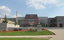
Michels Corporation has its corporate headquarters in Brownsville.
References
- 1 2 "US Gazetteer files 2010". United States Census Bureau. Archived from the original on 2012-07-14. Retrieved 2012-11-18.
- 1 2 "US Board on Geographic Names". United States Geological Survey. 2007-10-25. Retrieved 2008-01-31.
- 1 2 "American FactFinder". United States Census Bureau. Retrieved 2012-11-18.
- ↑ "Population Estimates". United States Census Bureau. Archived from the original on 2013-06-17. Retrieved 2013-06-24.
- 1 2 "American FactFinder". United States Census Bureau. Archived from the original on 2013-09-11. Retrieved 2008-01-31.
- ↑ "US Gazetteer files: 2010, 2000, and 1990". United States Census Bureau. 2011-02-12. Retrieved 2011-04-23.
- ↑ "Annual Estimates of the Resident Population for Incorporated Places: April 1, 2010 to July 1, 2015". Retrieved July 2, 2016.
- ↑ "Census of Population and Housing". Census.gov. Archived from the original on May 11, 2015. Retrieved June 4, 2015.
External links
| Wikimedia Commons has media related to Brownsville, Wisconsin. |
Municipalities and communities of Dodge County, Wisconsin, United States | ||
|---|---|---|
| Cities | 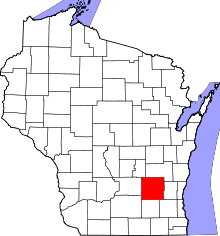 | |
| Villages | ||
| Towns | ||
| CDPs | ||
| Unincorporated communities |
| |
| Ghost towns | ||
| Footnotes | ‡This populated place also has portions in an adjacent county or counties | |