Ashippun (CDP), Wisconsin
| Ashippun, Wisconsin | |
|---|---|
| Census-designated place | |
|
Sign | |
 Ashippun | |
| Coordinates: 43°12′43″N 88°30′58″W / 43.21194°N 88.51611°WCoordinates: 43°12′43″N 88°30′58″W / 43.21194°N 88.51611°W | |
| Country | United States |
| State | Wisconsin |
| County | Dodge |
| Town | Ashippun |
| Area | |
| • Total | 0.288 sq mi (0.75 km2) |
| • Land | 0.288 sq mi (0.75 km2) |
| • Water | 0 sq mi (0 km2) |
| Elevation | 860 ft (260 m) |
| Population (2010 census) | |
| • Total | 333 |
| • Density | 1,200/sq mi (450/km2) |
| Time zone | Central (CST) (UTC-6) |
| • Summer (DST) | CDT (UTC-5) |
| ZIP code | 53003 |
| Area code(s) | 920 |
| GNIS feature ID | 1560978[1] |
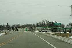

Welcome sign
Ashippun is an unincorporated census-designated place located in the town of Ashippun, Dodge County, Wisconsin, United States. Ashippun is located on Wisconsin Highway 67 7 miles (11 km) south of Neosho. Ashippun has a post office with ZIP code 53003.[2] As of the 2010 census, its population was 333.[3]
References
- ↑ U.S. Geological Survey Geographic Names Information System: Ashippun (CDP), Wisconsin
- ↑ ZIP Code Lookup Archived June 15, 2011, at the Wayback Machine.
- ↑ "American FactFinder". U.S. Census Bureau. Archived from the original on 23 April 2011. Retrieved 29 March 2011.
Municipalities and communities of Dodge County, Wisconsin, United States | ||
|---|---|---|
| Cities | 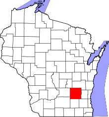 | |
| Villages | ||
| Towns | ||
| CDPs | ||
| Unincorporated communities |
| |
| Ghost towns | ||
| Footnotes | ‡This populated place also has portions in an adjacent county or counties | |
This article is issued from Wikipedia - version of the 11/17/2016. The text is available under the Creative Commons Attribution/Share Alike but additional terms may apply for the media files.