Briançon
| Briançon | ||
|---|---|---|
|
A view of the Collegiate Church of Notre-Dame and Saint-Nicolas | ||
| ||
 Briançon | ||
|
Location within Provence-A.-C.d'A. region  Briançon | ||
| Coordinates: 44°53′47″N 6°38′08″E / 44.8964°N 6.6356°ECoordinates: 44°53′47″N 6°38′08″E / 44.8964°N 6.6356°E | ||
| Country | France | |
| Region | Provence-Alpes-Côte d'Azur | |
| Department | Hautes-Alpes | |
| Arrondissement | Briançon | |
| Intercommunality | Briançon | |
| Government | ||
| • Mayor (2009–2014) | Gérard Fromm | |
| Area1 | 28.07 km2 (10.84 sq mi) | |
| Population (2008)2 | 11,645 | |
| • Density | 410/km2 (1,100/sq mi) | |
| Time zone | CET (UTC+1) | |
| • Summer (DST) | CEST (UTC+2) | |
| INSEE/Postal code | 05023 / 05100 | |
| Elevation | 1,167–2,540 m (3,829–8,333 ft) | |
|
1 French Land Register data, which excludes lakes, ponds, glaciers > 1 km² (0.386 sq mi or 247 acres) and river estuaries. 2 Population without double counting: residents of multiple communes (e.g., students and military personnel) only counted once. | ||


Briançon (French pronunciation: [bʁi.jɑ̃.sɔ̃]) a commune in the Hautes-Alpes department in the Provence-Alpes-Côte d'Azur region in southeastern France. It is a sub-prefecture of the department.
At an altitude of 1,326 metres (4,350 feet) it is the highest city in France, based on the French definition as a community containing more than 2,000 inhabitants. Briançon's most recent population estimate is 11,645.
Briançon is built on a plateau centred on the confluence of the Durance and the Guisane rivers.
History
Briançon was the Brigantium of the Romans and formed part of the kingdom of King Cottius. Brigantium was marked as the first place in Gallia after Alpis Cottia (Mont Genèvre). At Brigantium the road branched, to the west through Grenoble to Vienna (modern Vienne), on the Rhone; to the south through Ebrodunum (modern Embrun), to Vapincum (modern Gap). Both the Antonine Itinerary and the Table give the route from Brigantium to Vapincum. The Table places Brigantium 6 M.P. from Alpis Cottia. Strabo[1] mentions the village Brigantium, and on a road to Alpis Cottia, but his words are obscure. Ptolemy mentions Brigantium as within the limits of the Segusini, or people of Segusio (modern Susa), in Piedmont; but it seems, as D'Anville observes, to be beyond the natural limits of the Segusini. Walckenaer (vol. i. p. 540) justifies Ptolemy in this matter by supposing that he follows a description of Italy made before the new divisions of Augustus, which we know from Pliny. Walckenaer also supports his justification of Ptolemy by the Jerusalem Itinerary, which makes the Alpes Cottiae commence at Rama (near modern La Roche-de-Rame) between Embrun and Briançon.
In the 1040s it came into the hands of the counts of Albon (later dauphins of the Viennois) and thenceforth shared the fate of the Dauphiné. The Briançonnais included not merely the upper valley of the Durance (with those of its affluents, the Gyronde and the Guil), but also the valley of the Dora Riparia (Césanne, Oulx, Bardonnèche and Exilles), and that of the Chisone (Fénestrelles, Pérouse, Pragelas)—these glens all lying on the eastern slope of the chain of the Alps. But by the Treaty of Utrecht (1713) all these valleys were handed over to Savoy in exchange for that of Barcelonnette, on the west slope of the Alps. In 1815 Briançon successfully withstood a siege of three months at the hands of the Allies, a feat which is commemorated by an inscription on one of its gates, Le passé répond de l'avenir.
Population
| Historical population | ||
|---|---|---|
| Year | Pop. | ±% |
| 1793 | 3,023 | — |
| 1800 | 2,666 | −11.8% |
| 1806 | 2,945 | +10.5% |
| 1821 | 2,835 | −3.7% |
| 1831 | 2,939 | +3.7% |
| 1836 | 3,455 | +17.6% |
| 1841 | 4,301 | +24.5% |
| 1846 | 4,309 | +0.2% |
| 1851 | 4,439 | +3.0% |
| 1856 | 4,601 | +3.6% |
| 1861 | 4,510 | −2.0% |
| 1866 | 3,579 | −20.6% |
| 1872 | 4,169 | +16.5% |
| 1876 | 4,491 | +7.7% |
| 1881 | 5,439 | +21.1% |
| 1886 | 5,777 | +6.2% |
| 1891 | 6,580 | +13.9% |
| 1896 | 7,177 | +9.1% |
| 1901 | 7,426 | +3.5% |
| 1906 | 7,524 | +1.3% |
| 1911 | 7,888 | +4.8% |
| 1921 | 5,013 | −36.4% |
| 1926 | 5,636 | +12.4% |
| 1931 | 6,822 | +21.0% |
| 1936 | 7,543 | +10.6% |
| 1946 | 6,671 | −11.6% |
| 1954 | 8,274 | +24.0% |
| 1962 | 7,570 | −8.5% |
| 1968 | 8,215 | +8.5% |
| 1975 | 9,489 | +15.5% |
| 1982 | 9,710 | +2.3% |
| 1990 | 11,041 | +13.7% |
| 1999 | 10,729 | −2.8% |
| 2006 | 11,542 | +7.6% |
Sights
.jpg)
The historical centre is a strongly fortified town, built by Vauban to defend the region from Austrians in the 17th century. Its streets are very steep and narrow, though picturesque. Briançon lies at the foot of the descent from the Col de Montgenèvre, giving access to Turin, so a great number of other fortifications have been constructed on the surrounding heights, especially towards the east. The Fort Janus is no less than 1,200 m. above the town.
The parish church, with its two towers, was built 1703–1726, and occupies a very conspicuous position.
The Pont d'Asfeld, east of the town, was built in 1734, and forms an arch of 40 m span, thrown at a height of 56 m across the Durance.
The modern town extends in the plain at the southwest foot of the plateau on which the old town is built and forms the suburb of Ste Catherine.
Briançon is close to the Parc National des Ecrins and the Vallée de la Clarée.
On 8 July 2008, several buildings of Briançon were classified by the UNESCO as World Heritage Sites, as part of the "Fortifications of Vauban" group. These buildings are: the city walls, Redoute des Salettes, Fort des Trois-Têtes, Fort du Randouillet, ouvrage de la communication Y and the Asfeld Bridge. Along with Briançon, 11 other sites of fortified buildings in France were classified. Among them is the place-forte of Mont-Dauphin, also in the Hautes-Alpes department. These pieces of art were designed by Sébastien Le Prestre de Vauban (1633–1707), a military engineer of King Louis XIV.
Personalities
The following people were either born in Briançon or lived there for a significant portion of their lives.
- Starting with Jacques Challiol, members of the Challiol family served as the Vice Bailiffs of the Briançonnais region for more than 400 years.
- Oronce Fine (1494–1555), mathematician and cartographer
- Augustin Chenu (1833-1875), painter
- Emilie Carles (1900–1979), author
- Jules Melquiond (born 1941), Alpine ski racer
- Henry Bréchu (born 1947), Alpine ski racer
- Luc Alphand (born 1965), Alpine ski racer
- Benjamin Melquiond (born 1975), Alpine ski racer
- Nicolas Bonnet (born 1984), ski mountaineer and runner.
- Laure Barthélémy (born 1988), cross-country skier.
- Richard Jouve (born 1994), cross-country skier.
International relations
Twin towns – Sister cities
Briançon is twinned with:
Sport
Cycling
Briançon has often hosted starts and finishes of stages of the Tour de France, Giro d'Italia and Dauphiné Libéré
As Briançon has regularly featured as a stage town in the Tour de France, it is a popular base for cyclists. Since 1947, the town has been the start point for a stage of the Tour 22 times, and has also been a stage finish 22 times.
In 2007, the town was the finish of the 159.5 km (99.1 mi) stage 9 on 17 July from Val-d'Isère crossing the Col de l'Iseran, the Col du Télégraphe and the Col du Galibier with a 37 km (23 mi) downhill finish to Briançon.
Ice hockey
The Diables Rouges de Briançon play in the Ligue Magnus, the French top league.
Kayaking
Briançon is situated around the confluence of the Durance river and its tributary the Guisane which are fed with snow melt in the Spring. Tourists come from around Europe to kayak and raft on the resultant whitewater rivers and their tributaries, including the Onde, the Gyronde, the Guil, the Rabioux, the Ubaye and others; often basing themselves in Briançon.
Popular white water rivers in the Alps are mainly medium volume glacier-fed rivers with long continuous rapids and few big drops. The season is short (two or three months in early summer when the snow and glaciers are melting) but the whitewater is reliable during this period.
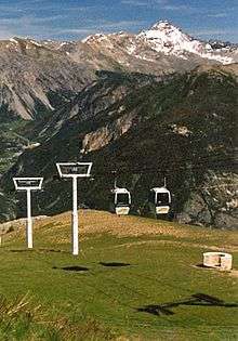
Skiing
Briançon is the base and lowest altitude station of the large Serre Chevalier ski resort. Most of the town's accommodation is used exclusively in winter, the population tripling during that period.
See also
References
- ↑ Strabo, iv.
 This article incorporates text from a publication now in the public domain: Chisholm, Hugh, ed. (1911). "Briançon". Encyclopædia Britannica (11th ed.). Cambridge University Press.
 This article incorporates text from a publication now in the public domain: Smith, William, ed. (1854–1857). "article name needed". Dictionary of Greek and Roman Geography. London: John Murray.
External links
| Wikimedia Commons has media related to Briançon. |
| Wikisource has the text of the 1911 Encyclopædia Britannica article Briançon. |
- About the city of Briançon (French), (German)
- Tourist office website (French)
- Unofficial town website (French)
- Webpage about the fortifications
- Briançon dans le Tour de France