Vars, Hautes-Alpes
| Vars | ||
|---|---|---|
|
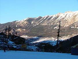
The mountainous landscape around Vars | ||
| ||
 Vars | ||
|
Location within Provence-A.-C.d'A. region  Vars | ||
| Coordinates: 44°35′45″N 6°41′26″E / 44.5958°N 6.6906°ECoordinates: 44°35′45″N 6°41′26″E / 44.5958°N 6.6906°E | ||
| Country | France | |
| Region | Provence-Alpes-Côte d'Azur | |
| Department | Hautes-Alpes | |
| Arrondissement | Briançon | |
| Canton | Guillestre | |
| Intercommunality | Guillestre | |
| Government | ||
| • Mayor (2008–2014) | Pierre Eyméoud | |
| Area1 | 92.2 km2 (35.6 sq mi) | |
| Population (2008)2 | 606 | |
| • Density | 6.6/km2 (17/sq mi) | |
| Time zone | CET (UTC+1) | |
| • Summer (DST) | CEST (UTC+2) | |
| INSEE/Postal code | 05177 / 05560 | |
| Elevation |
1,320–3,381 m (4,331–11,093 ft) (avg. 1,650 m or 5,410 ft) | |
|
1 French Land Register data, which excludes lakes, ponds, glaciers > 1 km² (0.386 sq mi or 247 acres) and river estuaries. 2 Population without double counting: residents of multiple communes (e.g., students and military personnel) only counted once. | ||

Vars is a commune in the Hautes-Alpes department in southeastern France.
It is famous for its ski resort, with seven snow parks and 185 kilometres (115 mi) of ski slopes.[1]
Population
| Historical population | ||
|---|---|---|
| Year | Pop. | ±% |
| 1962 | 245 | — |
| 1968 | 433 | +76.7% |
| 1975 | 779 | +79.9% |
| 1982 | 897 | +15.1% |
| 1990 | 941 | +4.9% |
| 1999 | 637 | −32.3% |
| 2008 | 606 | −4.9% |
See also
References
- ↑ "Four Top Resorts for Riding Park". Snowtrax Blog. Retrieved 18 March 2015.
| Wikimedia Commons has media related to Vars, Hautes-Alpes. |
This article is issued from Wikipedia - version of the 3/18/2015. The text is available under the Creative Commons Attribution/Share Alike but additional terms may apply for the media files.