Blaye
| Blaye | ||
|---|---|---|
 | ||
| ||
 Blaye | ||
|
Location within Nouvelle-Aquitaine region  Blaye | ||
| Coordinates: 45°07′43″N 0°39′40″W / 45.1286°N 0.6611°WCoordinates: 45°07′43″N 0°39′40″W / 45.1286°N 0.6611°W | ||
| Country | France | |
| Region | Nouvelle-Aquitaine | |
| Department | Gironde | |
| Arrondissement | Blaye | |
| Canton | Blaye | |
| Government | ||
| • Mayor (2008–2014) | Denis Baldès | |
| Area1 | 6.42 km2 (2.48 sq mi) | |
| Population (2008)2 | 4,959 | |
| • Density | 770/km2 (2,000/sq mi) | |
| Time zone | CET (UTC+1) | |
| • Summer (DST) | CEST (UTC+2) | |
| INSEE/Postal code | 33058 / 33390 | |
| Elevation |
0–41 m (0–135 ft) (avg. 7 m or 23 ft) | |
|
1 French Land Register data, which excludes lakes, ponds, glaciers > 1 km² (0.386 sq mi or 247 acres) and river estuaries. 2 Population without double counting: residents of multiple communes (e.g., students and military personnel) only counted once. | ||
.svg.png)
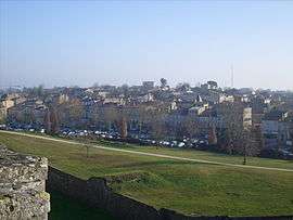
Blaye (French pronunciation: [blaj]; Occitan: Blaia pronounced [ˈblajɔ]) is a commune and subprefecture in the Gironde department in Nouvelle-Aquitaine in southwestern France.
Population
| Historical population | ||
|---|---|---|
| Year | Pop. | ±% |
| 1793 | 4,715 | — |
| 1800 | 3,580 | −24.1% |
| 1806 | 3,428 | −4.2% |
| 1821 | 4,013 | +17.1% |
| 1831 | 3,855 | −3.9% |
| 1836 | 3,801 | −1.4% |
| 1841 | 4,174 | +9.8% |
| 1846 | 4,410 | +5.7% |
| 1851 | 4,659 | +5.6% |
| 1856 | 4,302 | −7.7% |
| 1861 | 4,972 | +15.6% |
| 1866 | 4,761 | −4.2% |
| 1872 | 4,478 | −5.9% |
| 1876 | 4,522 | +1.0% |
| 1881 | 4,512 | −0.2% |
| 1886 | 4,340 | −3.8% |
| 1891 | 5,015 | +15.6% |
| 1896 | 4,799 | −4.3% |
| 1901 | 4,775 | −0.5% |
| 1906 | 4,890 | +2.4% |
| 1911 | 4,741 | −3.0% |
| 1921 | 4,274 | −9.9% |
| 1926 | 4,240 | −0.8% |
| 1931 | 4,054 | −4.4% |
| 1936 | 3,768 | −7.1% |
| 1946 | 3,788 | +0.5% |
| 1954 | 4,047 | +6.8% |
| 1962 | 4,291 | +6.0% |
| 1968 | 4,355 | +1.5% |
| 1975 | 4,051 | −7.0% |
| 1982 | 4,559 | +12.5% |
| 1990 | 4,286 | −6.0% |
| 1999 | 4,666 | +8.9% |
| 2008 | 4,959 | +6.3% |
Its inhabitants are called Blayais or the Blayaises.
Geography
Blaye is located on the right bank of the Gironde estuary (which is some 3 km (1.9 mi) wide at this point), close to the A10 autoroute, 56 km (35 mi) north of Bordeaux. There is a rail line with occasional freight trains, but no passenger services. A small ferry crosses the Gironde to Lamarque, in Medoc.
History
In ancient times Blaye (Blavia) was a port of the Santones. Tradition states that the Frankish hero Roland was buried in its basilica, which was on the site of the citadel. It was early an important stronghold which played an important part in the wars against the English (who burnt it in 1352) and the French Wars of Religion (when it was the site of a Spanish naval victory in 1593). The duchess of Berry was imprisoned in its fortress in 1832-1833.[1]
The town was formerly named Blaye-et-Sainte-Luce and was renamed Blaye in June 1961.
Sights
The town has a citadel built by Vauban on a rock beside the river, and embracing in its ancient ruins of an old Gothic château. The latter contains the tomb of Charibert II, king of Aquitaine, and son of Clotaire II. Blaye is also defended by the Fort Paté on an island in the river and the Fort Médoc on its left bank, both of the 17th century.[1]
The citadel of Blaye, its city walls, the Fort Paté and the Fort Médoc (the latter in nearby Cussac-Fort-Médoc) were listed in 2008 as UNESCO World Heritage Sites, as part of the "Fortifications of Vauban" group.
Economy
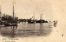
Blaye has a small river-port, mainly used for grain exports. Fine red wine is produced in the district, in the AOC Côtes de Blaye. A large nuclear power station with four reactors[2] is located nearby.
Education
Several schools are located in Blaye .
Public schools include the following:
- École Maternelle Pierre Bergeon
- École Maternelle Lucien Grosperrin
- École Elementaire Pierre Malbeteau
- École Elementaire Andre Vallaeys
Legal institutions
The town has tribunals of first instance and of commerce.
See also
References
- 1 2
 One or more of the preceding sentences incorporates text from a publication now in the public domain: Chisholm, Hugh, ed. (1911). "Blaye-et-Ste Luce". Encyclopædia Britannica. 4 (11th ed.). Cambridge University Press. p. 49.
 - ↑ "Archived copy". Archived from the original on 2011-06-04. Retrieved 2008-10-15.
External links
| Wikimedia Commons has media related to Blaye. |
- Town council website (in French)
- Personal website about Blaye (in French)
- Webpage about Blaye Citadel
- Another webpage about Blaye Citadel