Birim South District
| Birim South District | ||
|---|---|---|
| District | ||
| ||
 Eastern Region districts | ||
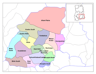
 Birim South District Location of Birim South district in Eastern Region | ||
| Coordinates: 5°53′39.98″N 1°0′55.22″W / 5.8944389°N 1.0153389°WCoordinates: 5°53′39.98″N 1°0′55.22″W / 5.8944389°N 1.0153389°W | ||
| Region | Eastern Region | |
| Capital | Akim Swedru | |
| District | 2008 | |
| Named for | Birim River | |
| Seat | District Assembly | |
| Boroughs |
Councils
| |
| Government | ||
| • District Executive | Baffour Mensah-Takyi | |
| • Presiding Member | Kwaku Amoah Bosompem | |
| Area | ||
| • Total | 299.5 km2 (115.6 sq mi) | |
| Time zone | Greenwich Mean Time (UTC+0) | |
| • Summer (DST) | GMT (UTC) | |
| Area code(s) | +233 34 292 | |
| Website | Official website | |
The Birim South District is one of the twenty-one (21) districts of the Eastern Region of south Ghana. The Birim River flows through Birim South district. The capital is Akim Swedru.[1]
History
The old Birim South District with capital at Akim Oda was split into two forming the Birim Central Municipal District and the smaller and new Birim South District. Akim Oda remains capital of the Birim Central Municipal District while the new Birim South District has its capital at Akim Swedru. Birim South administrative district was created in 2008 by the NPP Kufuor government.[1]
Boundaries
The Birim South district is located in the south of Eastern Ghana. It is bordered on the north east by the Birim Central Municipal District. To the west is the Assin North Municipal District in the Central Region and to the south, the Asikuma-Odoben-Brakwa and Agona West Districts, also in the Central Region.[1]
Geography
The district covers an area of 299.5 square kilometres. Within it are a lot of hills, streams and rivers. It has 2 peak rain seasons during May–June and September–October. The relative humidity ranges from 56% during the dry season and 70% during the rainy season. The district lies within a semi-deciduous rainforest region.[1]
Demographics
The population is 47.6% male and 51.4% female.[1] 56% of the population live in rural areas.[1]
Administration
The highest political and administrative body in the district is the District Assembly. The District Executive is the political and administrative head. The assembly also has a presiding member who is the chairperson. There are 3 sub-district councils. They are the Akim Swedru Urban Council, Achiasi Town Council and the Aperadi Area Council.[1]
List of settlements
The town of Akim Swedru, is the capital. The other major settlements in the Birim South district are Achiasi and Aperadi. Achiasi is the main commercial centre.[1]
| Settlements of Birim South District | |||
| No. | Settlement | Population | Population year |
|---|---|---|---|
| 1 | Achiasi | ||
| 2 | Adiembra | ||
| 3 | Aduasa | ||
| 4 | Aggreykrom | ||
| 5 | Akenkausu | ||
| 6 | Akim Swedru | 10,379 | 2013 |
| 7 | Akortekrom | ||
| 8 | Akyem Swedru | ||
| 9 | Anamase | ||
| 10 | Anyinam | ||
| 11 | Aperadi | ||
| 12 | Apoli | ||
| 13 | Awisa | ||
| 14 | Bieni | ||
| 15 | Bomoden | ||
| 16 | Duakon | ||
| 17 | Kokobeng | ||
| 18 | Nyankomase | ||
| 19 | Osorase | ||
See also
References
Sources
- "Birim South district". Statoids.
- Districts: Birim South
| Municipal |
| |
|---|---|---|
| District |
| |