Big Twenty Township, Maine
The Big Twenty Township is an administrative division in Aroostook County in northern Maine.[1] It is one of the largest townships in Maine, and contains Estcourt Station, a village of four people that is the northernmost point in Maine. The township also contains the northernmost point in New England and one of the northernmost points in the continental United States.[2]
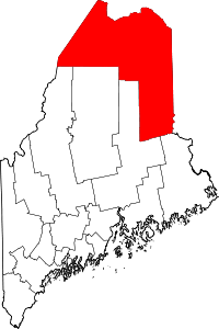
Geography
The Big Twenty Township is made up of two separate survey townships, T20 R11 and T20 R12 WELS. It is bordered by Quebec, Canada to the north, east, and west, and by T19 R11 and T19 R12 WELS to the south.[3] The borders of the township were settled on August 9, 1842, with the signing of the Webster–Ashburton Treaty. The treaty, named for US Secretary of State Daniel Webster and United Kingdom Privy Counsellor Lord Ashburton, ended the Aroostook War and also set the Canada–United States border further west.[4]
Population
The Big Twenty Township has fewer than 20 year-round residents. The land is used mainly for logging, and the only roads that exist are logging roads; there are no state highways. Some of the land is owned by camp owners, and several camps straddle the US-Canada border.[4]
Many of the people who visit Big Twenty Township are Canadians who have illegally crossed the border in search of cheaper food and gas. One such incident occurred in 2002, when Michel Jalbert crossed the border in to save 20 cents a gallon on gas and was arrested and imprisoned. Some people even have property that straddles the border, and have received written consent from border patrol to cross the border when they want to avoid issues.[5]
References
- ↑ "Big Twenty, Township of, Aroostook County, Maine, USA". Archived from the original on 2010-07-04. Retrieved 2009-06-22.
- ↑ "Turn Maine Blue:: How not to Announce a Candidacy". Retrieved 2009-06-22.
- ↑ "Maine Department of Labor" (PDF). Archived from the original (PDF) on August 20, 2008. Retrieved 2009-06-22.
- 1 2 Sample, Tim; Steve Bither. Maine Curiosities. pp. 24–26.
- ↑ "Michel Jalbert: victimized to save face on both sides of the border". Archived from the original on 11 May 2009. Retrieved 2009-06-22.
- "Township of Big Twenty". Geographic Names Information System. United States Geological Survey. 24 April 2003. Retrieved 2010-11-02.
Coordinates: 47°25′N 69°10′W / 47.417°N 69.167°W