Bartlett, Texas
| Bartlett, Texas | |
|---|---|
| City | |
|
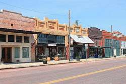
Bartlett Commercial Historic District | |
 Location of Bartlett, Texas | |
 | |
| Coordinates: 30°47′44″N 97°25′50″W / 30.79556°N 97.43056°WCoordinates: 30°47′44″N 97°25′50″W / 30.79556°N 97.43056°W | |
| Country | United States |
| State | Texas |
| Counties | Williamson, Bell |
| Area | |
| • Total | 1.22 sq mi (3.16 km2) |
| • Land | 1.22 sq mi (3.15 km2) |
| • Water | 0.004 sq mi (0.01 km2) |
| Elevation | 597 ft (182 m) |
| Population (2010) | |
| • Total | 2,684 |
| • Density | 2,208/sq mi (852.7/km2) |
| Time zone | Central (CST) (UTC-6) |
| • Summer (DST) | CDT (UTC-5) |
| ZIP code | 76511 |
| Area code(s) | 254 |
| FIPS code | 48-05732[1] |
| GNIS feature ID | 1351556[2] |
Bartlett is a city in Bell and Williamson counties in the U.S. state of Texas. The population was 2,684 at the 2010 census.[3]
Bartlett lies in two counties as well as two metropolitan areas. The Bell County portion of the city is part of the Killeen–Temple–Fort Hood Metropolitan Statistical Area, while the Williamson County portion is part of the Austin–Round Rock Metropolitan Statistical Area. Known for its late nineteenth and early twentieth century architecture, Bartlett was the site for the filming of movies including The Stars Fell on Henrietta and The Dalton Boys, as well as the NBC television drama Revolution.
Geography
Bartlett is located at 30°47′44″N 97°25′50″W / 30.795621°N 97.430680°W (30.795621, -97.430680).[4] It is 24 miles (39 km) south of Temple and 50 miles (80 km) northeast of downtown Austin. The city straddles the line between Bell and Williamson counties; the center of the city is mostly in Bell County, but the slight majority of the city's area is in Williamson County.
According to the United States Census Bureau, the city has a total area of 1.2 square miles (3.2 km2), of which 0.004 square miles (0.01 km2), or 0.24%, is water.[3]
Demographics
| Historical population | |||
|---|---|---|---|
| Census | Pop. | %± | |
| 1890 | 206 | — | |
| 1900 | 957 | 364.6% | |
| 1910 | 1,815 | 89.7% | |
| 1920 | 1,731 | −4.6% | |
| 1930 | 1,873 | 8.2% | |
| 1940 | 1,668 | −10.9% | |
| 1950 | 1,727 | 3.5% | |
| 1960 | 1,540 | −10.8% | |
| 1970 | 1,622 | 5.3% | |
| 1980 | 1,567 | −3.4% | |
| 1990 | 1,439 | −8.2% | |
| 2000 | 1,675 | 16.4% | |
| 2010 | 1,623 | −3.1% | |
| Est. 2015 | 2,761 | [5] | 70.1% |
At the 2000 census,[1] there were 1,675 people, 571 households and 404 families residing in the city. The population density was 1,373.3 per square mile (530.1/km2). There were 638 housing units at an average density of 523.1 per square mile (201.9/km2). The racial makeup of the city was 61.61% White, 17.97% African American, 0.66% Native American, 0.06% Asian, 16.84% from other races, and 2.87% from two or more races. Hispanic or Latino of any race were 33.07% of the population.
There were 571 households of which 35.0% had children under the age of 18 living with them, 52.0% were married couples living together, 14.5% had a female householder with no husband present, and 29.1% were non-families. 27.3% of all households were made up of individuals and 16.5% had someone living alone who was 65 years of age or older. The average household size was 2.78 and the average family size was 3.40.
Age distribution was 29.3% under the age of 18, 8.8% from 18 to 24, 23.0% from 25 to 44, 19.9% from 45 to 64, and 18.9% who were 65 years of age or older. The median age was 36 years. For every 100 females there were 91.2 males. For every 100 females age 18 and over, there were 83.9 males.
The median household income was $26,094, and the median family income was $35,595. Males had a median income of $22,273 versus $21,016 for females. The per capita income for the city was $12,649. About 21.1% of families and 25.6% of the population were below the poverty line, including 29.5% of those under age 18 and 30.3% of those age 65 or over.
Education
Bartlett is served by the Bartlett Independent School District and is home to the Bartlett High School Bulldogs. There are plans to renovate the schools currently up for a vote.
Notable people
- Henry Ray Clark, artist, 1936-2006
- John C. Holland, Los Angeles City Council member, 1943–67
Climate
The climate in this area is characterized by hot, humid summers and generally mild to cool winters. According to the Köppen Climate Classification system, Bartlett has a humid subtropical climate, abbreviated "Cfa" on climate maps.[7]
References
- 1 2 "American FactFinder". United States Census Bureau. Archived from the original on 2013-09-11. Retrieved 2008-01-31.
- ↑ "US Board on Geographic Names". United States Geological Survey. 2007-10-25. Retrieved 2008-01-31.
- 1 2 "Geographic Identifiers: 2010 Demographic Profile Data (G001): Bartlett city, Texas". U.S. Census Bureau, American Factfinder. Retrieved April 10, 2014. Revised 2010 census figure published 07-02-2012.
- ↑ "US Gazetteer files: 2010, 2000, and 1990". United States Census Bureau. 2011-02-12. Retrieved 2011-04-23.
- ↑ "Annual Estimates of the Resident Population for Incorporated Places: April 1, 2010 to July 1, 2015". Retrieved July 2, 2016.
- ↑ "Census of Population and Housing". Census.gov. Archived from the original on May 11, 2015. Retrieved June 4, 2015.
- ↑ Climate Summary for Bartlett, Texas
External links
- Bartlett Area Chamber of Commerce
- Williamson County Historical Commission page
- Bartlett from the Handbook of Texas Online
Municipalities and communities of Bell County, Texas, United States | ||
|---|---|---|
| Cities | 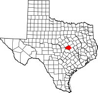 | |
| Towns | ||
| Village | ||
| CDP | ||
| Unincorporated communities |
| |
| Ghost towns |
| |
| Footnotes | ‡This populated place also has portions in an adjacent county or counties | |
Municipalities and communities of Williamson County, Texas, United States | ||
|---|---|---|
| Cities |  | |
| CDPs | ||
| Unincorporated communities | ||
| Ghost town | ||
| Footnotes | ‡This populated place also has portions in an adjacent county or counties | |