Anderson Ferry
|
Anderson Ferry | |
 | |
  | |
| Location | Between Cincinnati, Ohio and Constance, Kentucky |
|---|---|
| Coordinates | 39°4′35.16″N 84°37′28″W / 39.0764333°N 84.62444°WCoordinates: 39°4′35.16″N 84°37′28″W / 39.0764333°N 84.62444°W |
| Built | 1817 |
| NRHP Reference # | 82003575[1] |
| Added to NRHP | June 10, 1982 |
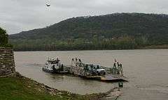
The Anderson Ferry is a ferry across the Ohio River between Cincinnati, Ohio and Constance, Kentucky. It has been in continuous operation since 1817. It was originally known as the Kottmyer ferry but was later sold to the Anderson family. The ferry was often used in the 19th century by Kentucky farmers bringing their product to market in Cincinnati.[2] It is the lone survivor of dozens of ferries that once served the Cincinnati area. The ferry is located about 8 miles (13 km) west of Downtown Cincinnati.[3]
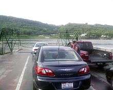
The ferry connects Anderson Ferry Road (a major arterial street on the Ohio side which traverses the City of Cincinnati; Delhi Township; and Green Township from south to north) with a short private road, which in turn connects with Kentucky Route 8 (the middle section) just east of its junction with Kentucky Route 20 near Constance, Kentucky. A short distance southwest from this junction is KY 20's junction with Kentucky Route 212, which provides the main access to the Cincinnati/Northern Kentucky International Airport. It provides a shortcut for Cincinnati westsiders going to the airport located in Boone County, Kentucky.[4]
References
- ↑ National Park Service (2007-01-23). "National Register Information System". National Register of Historic Places. National Park Service.
- ↑ Picturesque Cincinnati. John Shillito Company. 1883. p. 77.
- ↑ Thompson, George E. (2009). You Live Where?: Interesting and Unusual Facts about where We Live. iUniverse. p. 85.
- ↑ Felix Winternitz & Sacha DeVroomen Bellman (2007). Insiders' Guide to Cincinnati. Globe Pequot. p. 155. Retrieved 2013-05-08.

