Ambès
| Ambès | ||
|---|---|---|
|
Port | ||
| ||
 Ambès | ||
|
Location within Nouvelle-Aquitaine region  Ambès | ||
| Coordinates: 45°00′44″N 0°32′22″W / 45.0122°N 0.5394°WCoordinates: 45°00′44″N 0°32′22″W / 45.0122°N 0.5394°W | ||
| Country | France | |
| Region | Nouvelle-Aquitaine | |
| Department | Gironde | |
| Arrondissement | Bordeaux | |
| Canton | Lormont | |
| Intercommunality | Bordeaux | |
| Government | ||
| • Mayor (2008–2014) | Maurice Pierre | |
| Area1 | 28.85 km2 (11.14 sq mi) | |
| Population (2008)2 | 2,941 | |
| • Density | 100/km2 (260/sq mi) | |
| Time zone | CET (UTC+1) | |
| • Summer (DST) | CEST (UTC+2) | |
| INSEE/Postal code | 33004 / 33810 | |
| Elevation |
0–8 m (0–26 ft) (avg. 4 m or 13 ft) | |
|
1 French Land Register data, which excludes lakes, ponds, glaciers > 1 km² (0.386 sq mi or 247 acres) and river estuaries. 2 Population without double counting: residents of multiple communes (e.g., students and military personnel) only counted once. | ||
.svg.png)
Ambès (French pronunciation: [ɑ̃bɛs]; Occitan: Ambès) is a commune in the Gironde department in southwestern France.
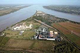
It is located at the point, the Bec d'Ambès (Occ. bèc is cognate with Old English bæc for beck[1]), where the rivers Garonne and Dordogne meet to form the Gironde estuary.
Population
| Historical population | ||
|---|---|---|
| Year | Pop. | ±% |
| 1962 | 2,046 | — |
| 1968 | 2,243 | +9.6% |
| 1975 | 2,545 | +13.5% |
| 1982 | 2,715 | +6.7% |
| 1990 | 2,567 | −5.5% |
| 1999 | 2,824 | +10.0% |
| 2008 | 2,941 | +4.1% |
See also
Gallery
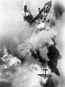
An Avro Lancaster of No. 514 Squadron RAF over the target during a Bomber Command attack on oil storage tanks at Bec d'Ambes in the Garonne estuary, 4 August 1944.
References
| Wikimedia Commons has media related to Ambès. |

This article is issued from Wikipedia - version of the 4/6/2016. The text is available under the Creative Commons Attribution/Share Alike but additional terms may apply for the media files.