Warm Springs, Nevada
| Warm Springs, Nevada | |
|---|---|
 Warm Springs, Nevada | |
| Coordinates: 38°11′26″N 116°22′12″W / 38.19056°N 116.37000°W | |
| Country | United States |
| State | Nevada |
| County | Nye |
| Elevation | 5,423 ft (1,653 m) |
| Time zone | Pacific (UTC-8) |
| • Summer (DST) | PDT (UTC-7) |
| ZIP code | 89049 |
Warm Springs is an unincorporated community in the Tonopah Basin and Nye County, Nevada, near the mountain pass which divides the Kawich and Hot Creek ranges (at 38°11′N 116°22′W / 38.19°N 116.37°W). It is located at the junction of U.S. Route 6 and State Route 375 (the "Extraterrestrial Highway"), around 40 miles east of Tonopah.
History

The first settlement in Warm Springs was in 1866, when it served as a stopover for stagecoaches and other travellers. Never more than a tiny settlement, Warm Springs' population dwindled until it became a ghost town. All that remained was a single streetlight, a telephone box, and several huts built over pools filled by the warm springs that give the town its name.
Warm Springs is also the name of a new community in Nevada at a different location, intended to have a final population of 10,000. Construction was completed in 2007.
External links
Municipalities and communities of Nye County, Nevada, United States | ||
|---|---|---|
| CDPs | 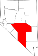 | |
| Other unincorporated communities | ||
| Ghost towns | ||