Alliance Clay Product Company
|
Alliance Clay Product Company | |
|
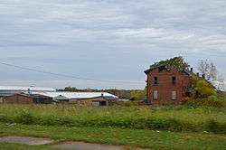
Abandoned buildings in the complex | |
  | |
| Nearest city | Alliance, Ohio |
|---|---|
| Coordinates | 40°54′13″N 81°4′57″W / 40.90361°N 81.08250°WCoordinates: 40°54′13″N 81°4′57″W / 40.90361°N 81.08250°W |
| Area | 713 acres (2.89 km2) |
| NRHP Reference # | 78002130[1] |
| Added to NRHP | 1978-12-08[1] |
The Alliance Clay Product Company District is a historic district in Alliance, Ohio, United States. Listed on the National Register of Historic Places in 1978, it includes twelve contributing properties.[1]
Historic uses
- Single Dwelling
- Manufacturing Facility
References
- 1 2 3 National Park Service (2007-06-30). "National Register Information System". National Register of Historic Places. National Park Service.


This article is issued from Wikipedia - version of the 11/25/2016. The text is available under the Creative Commons Attribution/Share Alike but additional terms may apply for the media files.