Aiguille de Bionnassay
| Aiguille de Bionnassay | |
|---|---|
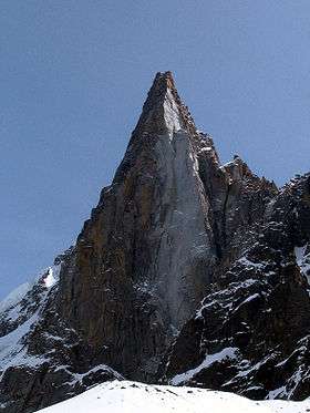
 Summit, east ridge and glaciated north-west face of the Aiguille de Bionnassay | |
| Highest point | |
| Elevation | 4,052 m (13,294 ft) |
| Prominence | 164 m (538 ft) [1] |
| Isolation | 1.8 kilometres (1.1 mi) |
| Coordinates | 45°50′09″N 06°49′05″E / 45.83583°N 6.81806°ECoordinates: 45°50′09″N 06°49′05″E / 45.83583°N 6.81806°E |
| Geography | |
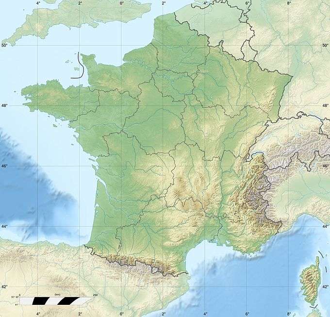 Aiguille de Bionnassay Location in France, on the border with Italy | |
| Location |
Haute-Savoie, Rhône-Alpes, France Aosta Valley, Italy |
| Parent range | Mont Blanc |
| Climbing | |
| First ascent | 28 July 1865 by Edward N. Buxton, Florence Crauford Grove and Reginald S. McDonald, with guides Jean Pierre Cachat and Michel Payot. (north-west face). |
.jpg)
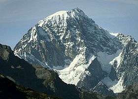
The Aiguille de Bionnassay (elevation 4,052 metres (13,294 ft)) is a mountain in the Mont Blanc massif of the Alps in France and Italy. It has been described as "one of the most attractive satellite peaks of Mont Blanc", and is located on its western side.[2]:51 The mountain's south and east ridges form the frontier between the two countries, and its summit is a knife-edge crest of snow and ice. Reaching it via any route provides a "splendid and serious snow and ice climb".[2]:51
Glaciers
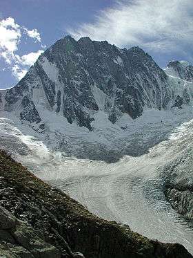
Three significant glaciers originate on the slopes of the mountain: The Glacier de Bionnassay, the Glacier de Bionnassay Italien, and the Glacier de Miage.
The Glacier de Bionnassay is the most obvious glacial feature, arising on the north and north-west slopes of the Aiguille de Bionnassay as well as from the western side of the Dôme du Goûter and the Aiguille du Goûter. It descends for approximately 4.5 km, flowing north-westwards before turning north at the foot of the Nid d'Aigle to end some distance above the settlement of Bionnassay, continuing as the Torrent de Bionnassay.[1] This hanging glacier on the north-west face of the Aiguille de Bionnassay provides a route of access for mountaineers with ice-climbing skills.[3]:202
The Glacier de Bionnassay Italien arises from a cirque between the south eastern side of the Aiguille de Bionnassay, the Col de Bionnassay and the Calotte des Aiguilles Grises. It descends south-south west for 2.5 km below the Col Infranchissable, then turns south-east to merge with other glaciers, thence continuing as the Glacier du Miage (Ghiacciaio del Miage) – a total distance of approximately 9 km, forming the longest glacier in Italy.[1][4]
The Glacier de Miage – not to be confused with the much larger Glacier du Miage on the Italian side (see above) – forms from snows collecting between the Aiguille de Tricot and the south-western face of the Aiguille de Bionnassay. The glacier descends in a south-westerly direction for approximately 2.5 km.[1]
Alpinism
Timeline of ascents
- The First Ascent of the Aiguille de Bionnassay was undertaken on 28 July 1865 by Florence Crauford Grove, Edward N. Buxton and Reginald S. McDonald, with guides Jean Pierre Cachat and Michel Payot. They ascended the north-west face to reach the ridge above the Aiguille de Tricot, from where they continued to the knife-edged summit ridge, arriving in a thunderstorm. A detailed account is given below.
- The mountain's South Ridge was first climbed on 13 July 1888 by Kaspar Maurer, Andreas Jaun and the Austrian diplomat Georg Gruber.[2]:51[3]:200
- The East Ridge was first climbed in descent as part of a traverse from the Dômes de Miage by Katharine Richardson, Emile Rey and Jean-Baptiste Bich on 13 August 1888.[2]:51
- The long West Ridge was first climbed in its entirety from the Col de Tricot in 1911 by Fraulein Eleonore Hasenclever and Freulein H. Wirthl with M. Helff, K.G. von Saar and Richard Weitzenbock.[3]
- The complete North-West Face route was finally climbed in 1926 by billionaire businessman and art collector, Robert Wylie Lloyd, with his guides Adolf and Josep Pollinger.[5]
- The first Winter Ascent of the Aiguille de Bionnassay was made on 20 March 1929 by A. Charlet, F. Frison Roche, H. Hoerlin, E.Schneider and H. Schroeder.[2]:51
- The North Face was first climbed on 30–31 August 1953 by Bertrand Kempf and Claude Laurendeau. It is ranked as one of the most difficult ice walls in the Alps, and is rarely attempted.[3]
Routes
- North-West Face: Graded at AD, the route is a steep, glaciated face between 40 and 55 degrees. There are numerous small crevasses in its steep slope providing sufficient resting places to reduce the exposure, but it is a long, demanding route of over 1 km, and can be difficult in times of hard ice. Climbers usually start from the Tête Rousse Hut. It is regarded as the finest route on the mountain, and one of the best of its class in the Alps.[2]:52 After snow it is avalanche prone; in one such incident in 1968 four climbers died.[3]:202
- South Ridge: An ascent from the Col de Miage (Durier Hut) provides the easiest route to the summit. The route consists of snowy ridges, rock ledges and chimneys.. It is graded at PD+ with rock pitches of II, often iced. A final steep snow ridge leads to the narrow and exposed summit on the French/Italian border.[6]
- East Ridge: Described as "a superb snow crest which is often precarious and delicate due to large cornices", the east ridge descends from the summit as an exposed and delicate knife-edge crest to the col de Bionnassay. AD. It can be reached from a traverse of the Bionnassay, or from the Gonella Hut.[2]
- West Ridge: A long 3.4 km ascent from the Col du Tricot over the Aigulle du Tricot, graded at PD.[2]
- Traverse: Crossing the mountain as part of a three-day ascent of Mont Blanc involves climbing up the south ridge of the Aiguille de Bionnassay from the Col de Miage, then descending from the summit down its razor-sharp, icy, and often corniced east (frontier) ridge. From there the route climbs again up the west ridge of the Dome du Gouter, past the Vallot Hut, to reach the Bosses ridge and thence to the summit of Mont Blanc. The route has been described as 'a truly magical expedition of ice and snow aretes at great altitude'.[3]:199 The Durier Hut on the Col de Miage can either be reached directly from the village of Tresse via an increasingly broken slope of scree in its upper reaches, or via a traverse from the Conscrits Hut over the Dômes de Miage.[2]:21
Account of first ascent (1865)
Florence Crauford Grove gave a detailed and wry account of his party's first 1865 ascent of the Aiguille Bionnassay in an article published in The Alpine Journal:[7]
Two years before their ascent, Grove had stood in the Hotel Royal in Chamouni (Chamonix), trying to persuade two young ladies and their father, who were using a telescope to view the peaks around Mont Blanc, that a black dot on the summit snowfield was not a person, but a distant rock some hundreds of feet in height. By chance they espied a real group of climbers, appearing as extremely small dots making their way across the Dôme du Goûter. Attempting to devise for them some imaginary route by which they might have reached that point, Grove showed them the fine snow crest descending in a gentle curve from the sharp and still unclimbed summit of the Aiguille de Bionnassay. The thought then struck him that an expedition to the summit, with an exit down the eastern ridge towards the easy Dôme du Goûter might actually make a fine undertaking.[7]:322
It was not until two years later that Grove stood again in Chamonix, this time accompanied by Edward Buxton and Reginald Macdonald, both of whom were keen to attain the unclimbed peak, especially as the Aiguille de Bionnassay was "the only peak passing thirteen thousand feet which had escaped the devastations of the Alpine Club". Their suggestion was not met enthusiastically by the two usual guides whom Grove employed: Jean Pierre Cachat and Michel Payot. Later that day, however, (27 July) they hired a carriage to carry them to Les Ouches (Les Houches) and then walked to the Pavillon de Belle Vue from where they could view the ice-clad slopes of the Bionnassay towering above them through what Grove describes as "the driving clouds and mist of a stormy afternoon". They retired to bed early, waking again at midnight for a 1 a.m. start, noting the sky was clear, but had a treacherous nature; fog banks were building up on the horizon and wisps of thin cloud streaked ominously across the sky.[7]:323
A third helper, a porter, had joined the two guides, solely to lead the party of five mountaineers down onto the Glacier de Bionnassay in darkness, well away from the normal route taken by others to reach the Aiguilles de Gouter. This task the porter utterly failed to do, and it was left to Cachat, the guide, to find a suitable track onto the ice in total darkness. Sunrise found them at the edge of the glacier, and their useless porter soon departed. Crossing the glacier, they climbed a prominent rock ridge to gain a better view and to ascertain their best route. At first they stared hopelessly at the glaciated slopes towering above them, realising a direct ascent to the summit was impossible. Grove later described it thus: "The ice in all its gaunt blue nakedness [was] raked by showers of grape from overhanging rock". Eventually they determined a sinuous route up through the billowing ice fields and avalanche debris to reach the crest of the ridge running from the Aiguille de Tricot to the summit of their mountain. Cachat led the way, hacking innumerable footholds in the steep ice until, some five hours after leaving the rock promontory, they finally attained the ridge, and found the day well-advanced and the weather deteriorating. Here they rested a while before continuing along the crest with a sheer ice slope dropping to one side and treacherous rocks on the other. By now the weather had changed and a heavy snowfall had begun. The ridge had become more exposed and a strong wind had developed. As each step was cut in the ice, their axes buzzed in the electrically charged air and they were forced to straddle the exposed, razor-sharp ridge as it was now completely impossible to stand. Grove later wrote that their "steel axe-heads gave out something musical in tone, but nevertheless evil to hear, for it told us we were now in the very heart of the thunderstorm".[7]:327
Eventually the ridge they were straddling began to slope downwards. They had at last reached, or had passed, the summit. It was 3 p.m., and through swirling cloud they glimpsed another razor-sharp ice ridge descending eastwards down to a col before curving gracefully upwards towards the Dome du Gouter. Grove recalled: "I thought it the most terrific [terrifying] thing I had ever seen in the Alps, but I am perfectly aware that a highly exaggerated impression is likely to be received of a ridge seen by half-frozen men in the middle of a tremendous storm, from the summit of a virgin peak".[7]:328
In the swirling cloud and snow they abandoned plans to descend via the sharp, unclimbed east ridge. Grove’s partner, Edward North Buxton, suggested remaining on the summit for a couple of hours to see if the weather would improve, but the rest of the party rejected his proposal, recognising there was neither sufficient daylight left for them to descend the impossibly exposed and unknown east ridge, nor to down-climb the sheer route they had just ascended. They chose instead to attempt a descent down the unknown southern side of the Aiguille de Bionnassay. They found it trying work to descending the steep ice bank from the summit in the furious storm, but managed eventually to find their way down through one stone-raked couloir to another on the mountain’s south-east face. As twilight fell they reached the head of the Glacier de Bionnassay Italian which formed the northern arm of the huge Glacier du Miage. Here, at a height well above that of the Col de Miage (3,300 m) upon which they could look down, they found refuge amongst rocks beside the steep glacier. They tried to rest there, having had nothing to drink all day except a little brandy and some tasteless wine that they had brought with them; glacial meltwater flowing beneath the rocks on which they sat were totally inaccessible to them. They were also wet through from the storm which by now had passed over, revealing a clear, starry sky. The trickles of water ceased as the temperature dropped below freezing and the night slowly became calm until the silence was shattered by the roar of rockfall over their heads. Abandoning their bivouac site, they took refuge amongst steeply sloping rocks which offered protection from stonefall, but no comfort whatsoever. After a miserable night’s rest, dawn eventually arrived and the ice-rimed party again began to descend the glacier, led by their guide, Cachat. Eight hours later they arrived at the village of St Gervais and sought appropriate refreshment in a well-to-do hotel, much to the disapprobation of the other guests who regarded their appearance and clothing with horror.[7]:331
Commenting on their first ascent, party member Edward Buxton observed that the noble peak’s summit was “still untrodden by man”, noting that “it was not on our feet that we got there.”[7]:331
Other notable events and incidents
- 1969: First descent on skis of the northwest face by extreme-skier, Sylvain Saudan, dubbed "skier of the impossible".[8]
- 1994: On 7 August a family of three English climbers were traversing the Aiguille de Bionnassay from the Durier Hut. Having taken longer than expected on the climb, they attempted to descend to the Rifugio Gonella in deteriorating weather conditions. A large snow bridge collapsed under the leader, Pam Caswell, pulling her son and then-husband, Steve, into the crevasse. He died of his injuries five hours later, but his wife and 16-year-old son were eventually rescued two days later.[9]
- 1997: In July, two climbers, Claire Kempster and Mike Haseler, died as they stepped back to take photographs on the summit of the Aiguille de Bionnassay. Kempster dived to catch a rucksack that was slipping down the ice slope, and the partner to whom she was roped was also swept away and killed. Another team member, who had just unroped from the group, survived.[10][11]
- 2007: In July four climbers from New Zealand, France, Chile and Britain died of exhaustion and cold on the ridge of the Bionnassay. News reports varied as to whether they were under-equipped, or if a party member had suffered from altitude-related sickness.[12][13]
- 2011: Two climbers from Annecy and Marseille who had ascended the summit of the Aiguille de Bionnassay and then descended the east ridge were found dead following bad weather when they failed to find the Vallot Hut and were forced to spend two nights out on the glacier in a crevasse near the Col du Gouter.[14]
Image gallery
-

North side of Aiguille de Bionnassay, seen from the Tête Rousse Hut
-

SE side of mountain with Glacier de Bionnassay Italien, S ridge and Aiguille de Tricot
-

The southern Italian side of the Aiguille de Bionnassay, with Aiguille Grises ridge in front
-

Glacier on NW face of Aiguille de Bionnassay
-

Cornice on the E ridge of the Aiguille de Bionnassay
-
Old moraines at the foot of Glacier du Miage on the Italian side
References
- 1 2 3 4 "Cartes IGN (French map portal)". www.geoportail.gouv.fr. Retrieved 22 November 2015.
- 1 2 3 4 5 6 7 8 9 Griffin, Lindsay (1990). Mont Blanc Massif Volume 1. London: Alpine Club. ISBN 0900523573.
- 1 2 3 4 5 6 Helmut Dumler and Willi P. Burkhardt, The High Mountains of the Alps, London: Diadem, 1994
- ↑ "Miage Glacier, Italy". earth.esa.int. European Space Agency. Retrieved 10 November 2015.
- ↑ Lloyd, Robert Wylie (1927). A Traverse of the Dent Blanche and the First Direct Ascent of the Aiguille de Bionnassay by the North Face. Spottiswoode, Ballantyne & Company, Limited.
- ↑ Goedeke, Richard (1990). The Alpine 4000m Peaks by the Classic Routes (1st ed.). London: Diadem Books. ISBN 3763410074.
- 1 2 3 4 5 6 7 F. Craufurd, Grove (September 1866). "The Ascent of the Aiguille de Bionnassay". The Alpine Journal. 2 (1865–1866): 321–332. Retrieved 10 November 2015.
- ↑ Davidof (14 November 2003). "Skier of the Impossible". pistehors.com. Retrieved 28 November 2015.
- ↑ Macdonald, Marianne (23 October 2011). "Alps survivor had to strip husband's body". The Independent. Retrieved 28 November 2015.
- ↑ Watson-Smyth, Kate (23 October 2011). "Death-fall climbers were posing for photographs". The Independent. Retrieved 28 November 2015.
- ↑ New York Times News Service (17 August 1997). "Hikers flock to Alps, but some can't elude peaks' dangers". www.deseretnews.com. Retrieved 28 November 2015.
- ↑ Bouanchaud, Cécile (12 July 2012). "Le Mont-Blanc, un sommet meurtrier". www.europe1.fr. Retrieved 28 November 2015.
- ↑ "Sickness may have slowed climbers killed in Alps". The Marlborough Express. 10 August 2007. Retrieved 28 November 2015.
- ↑ "2 climbers freeze to death on Mont Blanc". www.chamonix.net. 20 July 2011. Retrieved 28 November 2015.
External links
- Aiguille de Bionnassay on French IGN map portal
- Entry on SummitPost.org
- Entry on CampToCamp.org
- Entry on UkClimbing.com
- Entry on Die Viertausender der Alpen
- Video: Traverse of Aiguille de Bionnassay to Mont Blanc with views of the sharp east ridge.
- Video: Extreme ski-descent of N face of Aiguille de Bionnassay.