Chamonix
| Chamonix | ||
|---|---|---|
|
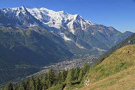
The Chamonix valley seen from la Flégère | ||
| ||
 Chamonix | ||
|
Location within Auvergne-Rhône-Alpes region  Chamonix | ||
| Coordinates: 45°55′23″N 6°52′11″E / 45.9231°N 6.8697°ECoordinates: 45°55′23″N 6°52′11″E / 45.9231°N 6.8697°E | ||
| Country | France | |
| Region | Auvergne-Rhône-Alpes | |
| Department | Haute-Savoie | |
| Arrondissement | Bonneville | |
| Canton | Chamonix-Mont-Blanc | |
| Intercommunality | Pays du Mont-Blanc | |
| Government | ||
| • Mayor (2014–20) | Éric Fournier | |
| Area1 | 245.46 km2 (94.77 sq mi) | |
| Population (2013)2 | 8,897 | |
| • Density | 36/km2 (94/sq mi) | |
| Time zone | CET (UTC+1) | |
| • Summer (DST) | CEST (UTC+2) | |
| INSEE/Postal code | 74056 / 74400 | |
| Elevation |
995–4,810 m (3,264–15,781 ft) (avg. 1,035 m or 3,396 ft) | |
|
1 French Land Register data, which excludes lakes, ponds, glaciers > 1 km² (0.386 sq mi or 247 acres) and river estuaries. 2 Population without double counting: residents of multiple communes (e.g., students and military personnel) only counted once. | ||
.svg.png)
Chamonix-Mont-Blanc,[note 1] more commonly known simply as Chamonix[note 2] (formerly also spelled Chamounix), is a commune in the Haute-Savoie département in the Auvergne-Rhône-Alpes region in south-eastern France. It was the site of the first Winter Olympics in 1924. The commune's population of around 8,900 ranks 1,089th within the country of France.[1]
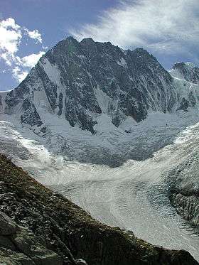
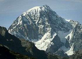
Situated near the massive peaks of the Aiguilles Rouges and most notably the Aiguille du Midi, Chamonix is one of the oldest ski resorts in France and is known as the "gateway to the European Cascades." The north side of the summit of Mont Blanc, and therefore the summit itself are part of the village of Chamonix. To the south side, the situation is different depending on the country. Italy considers that the border passes through the top. France considers that the boundary runs along the rocky Tournette under the summit cap, placing it entirely in French territory. The south side was in France, assigned to the commune of Saint-Gervais-les-Bains sharing the summit with its neighbor Chamonix. It is this situation "for France," which is found on the French IGN maps. The Chamonix commune is well known and loved by skiers and mountain enthusiasts of all types, and via the cable car lift to the Aiguille du Midi it is possible to access the world-famous off-piste skirun of the Vallée Blanche. With an area of 245 km2 (95 sq mi), Chamonix is the fourth largest commune in mainland France.
History
The valley was first mentioned in 1091, when it was granted by the Count of the Genevois to the great Benedictine house of St. Michel de la Cluse, near Turin, which by the early 13th century had established a priory there.[2] However, in 1786 the inhabitants bought their freedom from the canons of Sallanches, to whom the priory had been transferred in 1519.
In 1530, the inhabitants obtained from the Count of the Genevois the privilege of holding two fairs a year, while the valley was often visited by the civil officials and by the bishops of Geneva (first recorded visit in 1411, while St. Francis de Sales came there in 1606). But travellers for pleasure were very rare.

The first party to publish (1744) an account of their visit was that of Dr. Richard Pococke, Mr. William Windham and others, such as the Englishmen who visited the Mer de Glace in 1741. In 1742 came P. Martel and several other Genevese, in 1760 H.B. de Saussure,[2] and rather later Marc Th. Bourrit.
The growth of tourism in the early 19th century led to the formation of the Compagnie des Guides de Chamonix in 1821, to regulate access to the mountain slopes (which were communally or co-operatively owned), and this association held a monopoly of guiding from the town until it was broken by French government action in 1892; thereafter guides were required to hold a diploma issued by a commission dominated by civil servants and members of the French Alpine Club rather than local residents.
From the late 19th century on, tourist development was dominated by national and international initiatives rather than local entrepreneurs, though the local community was increasingly dependent upon and active in the tourist industry.
The commune successfully lobbied to change its name from Chamonix to Chamonix-Mont-Blanc in 1916. However, following the loss of its monopoly, the Compagnie reformed as an association of local guides, and retained an important role in local society; it provided the services of a friendly society to its members, and in the 20th century many of them were noted mountaineers and popularisers of mountain tourism, for example the novelist Roger Frison-Roche, the first member of the Compagnie not to be born in Chamonix.
The holding of the first Winter Olympic Games in Chamonix in 1924 further raised Chamonix's profile as an international tourist destination.
During the Second World War, a Children's Home operated in Chamonix, in which several dozens of Jewish children were hidden from the Nazis. Some of their saviors were recognised as "Righteous Among the Nations".[3]
By the 1960s, agriculture had been reduced to a marginal activity, while the number of tourist beds available rose to around 60,000 by the end of the 20th century, with about 5 million visitors a year.
Geography
Settlements
The commune of Chamonix-Mont-Blanc includes 16 villages and hamlets. From north to south: Le Tour 1,462 m (4,797 ft),[4] Montroc, Le Planet, Argentière 1,252 m (4,108 ft),[4] Les Chosalets, Le Lavancher, Les Tines, Les Bois, Les-Praz-de-Chamonix 1,060 m (3,478 ft),[4] Chamonix-Mont-Blanc, Les Pècles, Les Mouilles, Les Barrats, Les Pélerins, Les Gaillands, and Les Bossons 1,012 m (3,320 ft).[4]
Climate
Chamonix has a humid continental climate (Dfb, according to the Köppen climate classification), with an average annual precipitation of 1,275 mm (50 in). Summers are mild and winters are cold and snowy.
| Climate data for Chamonix (1981-2010) | |||||||||||||
|---|---|---|---|---|---|---|---|---|---|---|---|---|---|
| Month | Jan | Feb | Mar | Apr | May | Jun | Jul | Aug | Sep | Oct | Nov | Dec | Year |
| Average high °C (°F) | 2.6 (36.7) |
4.8 (40.6) |
9.0 (48.2) |
12.7 (54.9) |
17.6 (63.7) |
21.2 (70.2) |
23.9 (75) |
23.1 (73.6) |
19.1 (66.4) |
14.7 (58.5) |
7.4 (45.3) |
2.6 (36.7) |
13.23 (55.82) |
| Daily mean °C (°F) | −2.3 (27.9) |
−0.8 (30.6) |
3.0 (37.4) |
6.6 (43.9) |
11.2 (52.2) |
14.4 (57.9) |
16.5 (61.7) |
15.9 (60.6) |
12.5 (54.5) |
8.6 (47.5) |
2.7 (36.9) |
−1.6 (29.1) |
7.23 (45.02) |
| Average low °C (°F) | −7.2 (19) |
−6.4 (20.5) |
−3.0 (26.6) |
0.4 (32.7) |
4.8 (40.6) |
7.5 (45.5) |
9.1 (48.4) |
8.6 (47.5) |
6.0 (42.8) |
2.5 (36.5) |
−2.1 (28.2) |
−5.7 (21.7) |
1.21 (34.17) |
| Average precipitation mm (inches) | 93.8 (3.693) |
85.7 (3.374) |
85.7 (3.374) |
89.5 (3.524) |
120.5 (4.744) |
130.4 (5.134) |
115.5 (4.547) |
125.0 (4.921) |
102.3 (4.028) |
116.8 (4.598) |
100.6 (3.961) |
109.1 (4.295) |
1,274.9 (50.193) |
| Source: meteo-climat-bzh [5] | |||||||||||||
Demography
| 1793 | 1800 | 1806 | 1821 | 1836 | 1846 | 1856 | 1861 | 1866 |
|---|---|---|---|---|---|---|---|---|
| 1,830 | 1,925 | 1,949 | 2,232 | 2,528 | 2,304 | 2,308 | 2,304 | 2,415 |
| 1872 | 1876 | 1881 | 1886 | 1891 | 1896 | 1901 | 1906 | 1911 |
|---|---|---|---|---|---|---|---|---|
| 2,455 | 2,406 | 2,420 | 2,450 | 2,447 | 2,435 | 2,729 | 3,482 | 3,109 |
| 1921 | 1926 | 1931 | 1936 | 1946 | 1954 | 1962 | 1968 | 1975 |
|---|---|---|---|---|---|---|---|---|
| 3,040 | 3,811 | 4,446 | 4,633 | 5,883 | 5,699 | 7,213 | 7,745 | 8,393 |
| 1982 | 1990 | 1999 | 2006 | 2008 | - | - | - | - |
|---|---|---|---|---|---|---|---|---|
| 8,746 | 9,701 | 9,829 | 9,195 | 9,042 | - | - | - | - |
Sources : Ldh/EHESS/Cassini until 1962, INSEE database from 1968 (population without double counting and municipal population from 2006) · [6]
Population Over Time
|
|
||||||||||||||||||||||||||||||||||||||||||||||||||||||||||||||||||||||||||||||||||||||||||||||||||||||||||||||||||||||||||||||||||||||||||||||||||||||||||||||||||||||||||||||||||
|
|||||||||||||||||||||||||||||||||||||||||||||||||||||||||||||||||||||||||||||||||||||||||||||||||||||||||||||||||||||||||||||||||||||||||||||||||||||||||||||||||||||||||||||||||||
Mountain and winter sports
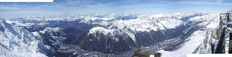
Chamonix is a winter sports resort town. As the highest European mountain west of Russia, Mont Blanc attracts mountain climbers. There is a cable car up to the 3,842 m (12,605 ft) Aiguille du Midi. Constructed in 1955, it was then the highest cable car in the world[7] and remains the highest vertical ascent cable car in the world.
Transportation
Roads
The town of Chamonix is served by French Route Nationale 205 (RN 205), nicknamed the Route blanche,[8] or "white route", due to its snowiness. This is an extension of French autoroute 40 (A40), similarly nicknamed the autoroute blanche, which ends at Le Fayet, a village in the commune of Saint-Gervais-les-Bains.[9] The 11.6-km Mont Blanc Tunnel originates here, linking Chamonix to Courmayeur in Italy.[10] Chamonix is linked to Switzerland by what used to be RN 506a. In 2006, it was converted to a Route Départementale 1506, with a part of it integrated into RN 205. The nearest airport to Chamonix is Geneva Cointrin International and it is 88 kilometres (55 miles) in distance.
Rail

Chamonix is served by the metre-gauge St Gervais-Vallorcine Line, operated by SNCF. The line from Saint Gervais (on the standard-gauge rail network) to Chamonix opened in 1901; it was extended to Vallorcine in 1908. The line holds the record for the steepest gradient on any standard (i.e. adhesion) railway.
From Vallorcine, the rail route continues over the border into Switzerland, meeting the SBB network at Martigny. This latter section, a metre-gauge cog railway, is operated by Transports de Martigny et Régions SA. The train service from Vallorcine to Martigny is known as the Mont Blanc Express. Timetables on the St Gervais-Vallorcine and Vallorcine-Martigny sections are synchronized.[11]
The 5.1-km Montenvers Railway is a cog railway that provides access to the tourist site of Montenvers. Opened in 1909, its rail station was built next to SNCF's Chamonix station on the St Gervais-Vallorcine Line. In fact the two stations are directly linked.[12] Montenvers provides further tourist access to middle and high mountain areas.[13]
Cable cars
Chamonix has one of the highest cable cars in the world, which links the town to the summit of the Aiguille du Midi at 3842 m.[14] It is based on an older system built in 1920, rebuilt in the first half of the 1950s over five summer seasons,[15] fully modernized in 1979, and upgraded again in 2008. On the other side of the valley, another cable car links Chamonix to the viewpoint of Planpraz. A second line links Planpraz to the summit of Le Brévent at 2525 m.[16][17] Many other cable cars exist in the valley, and are heavily used by skiers and residents. The Plan Joran chairlift at the base of Les Grands Montets is due to be replaced by a 10-person gondola for the Winter 2014/15 season.[18]
International relations
Twin towns — Sister cities
Chamonix is twinned with:
|
See also
- Communes of the Haute-Savoie department
- Mer de Glace
- Mont Blanc Massif
- Montroc
- The Haute Route from Chamonix to Zermatt
References
- ↑ Sources des données : INSEE – Chamonix: Données générales
- 1 2 The Development of the Appreciation of Mountain Scenery in Modern Times, Walter Woodburn Hyde, Geographical Review, Vol. 3, No. 2 (February 1917), pp. 107–118
- ↑ the Children's Home in Chamonix, at Yad Vashem website
- 1 2 3 4 "Chamonix Valley Website". Retrieved 2010-02-10.
- ↑ "Climate: moyennes 1981/2010". Retrieved 2 April 2015.
- ↑ Census of population on 1 January 2006 on the site of Insee.
- ↑ "Chamonix, Capitale Mondiale De L'alpinisme". Summit Post. 6 April 2008. Archived from the original on 13 April 2015. Retrieved 30 May 2016.
- ↑ Le Comité de préservation du village des Houches – Dossier publié le 12/05/2004 (PDF)
- ↑ Site de l'association de défense des usagers de l'A40 et de l'A41 – Revue de presse
- ↑ "Chamonix Valley Website". Retrieved 2010-02-10.
- ↑ "Mont Blanc Express timetables for 2010" (PDF). Retrieved 2010-02-10. [in French]
- ↑ Site de Christophe Jacquet spécialisé sur les trains du Mont-Blanc
- ↑ "Montenvers Mer De Glace". Compagnie du Montblanc. Archived from the original on 2 April 2016. Retrieved 30 May 2016.
- ↑ Site de l'Aiguille du Midi – Histoire du téléphérique Archived July 24, 2009, at the Wayback Machine.
- ↑ Cable Way to the Top of the Alps. Popular Mechanics, April 1956, pp. 81-84.
- ↑ "Map of the Brévent-Flégère area". Retrieved 2010-02-10.
- ↑ "Summer timetables for Chamonix gondolas and funicular railways". Retrieved 2010-02-10.
- ↑ New for Winter 2014/15 - http://www.skicollection.co.uk/Ski/Chamonix.htm
- ↑ Annuaire-Mairie.fr. "Ville d'Aoste" (in French). Retrieved 2013-06-18.
- ↑ "International Exchange". List of Affiliation Partners within Prefectures. Council of Local Authorities for International Relations (CLAIR). Retrieved 21 November 2015.
Notes
External links
| Wikimedia Commons has media related to Chamonix. |
 Chamonix travel guide from Wikivoyage
 "Chamonix". Encyclopædia Britannica. 5 (11th ed.). 1911.
- Official site of the city of Chamonix Mont-Blanc
- Impeding Hitler’s endeavour to capture Mont Blanc – The battle of the Vallée Blanche
|