Adolphus Channel
| Adolphus Channel | |
|---|---|
|
A map of the Torres Strait Islands, with the Adolphus Channel located south of Mount Adolphus Island in the Torres Strait | |
| Location | Northern Australia |
| Coordinates | 10°41′20″S 142°36′51″E / 10.688958°S 142.614167°ECoordinates: 10°41′20″S 142°36′51″E / 10.688958°S 142.614167°E |
| Type | Channel |
| Part of | Torres Strait |
| Ocean/sea sources |
Coral Sea, South Pacific Ocean |
| Basin countries | Australia |
| Managing agency | Torres Strait Island Region |
| Islands |
|
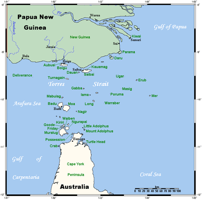
The Adolphus Channel or the Albany passage[1][2] is a channel located in the Torres Strait, situated northeast of the Cape York Peninsula, in Queensland, Australia. The channel runs north of the Albany Island, one of the islands if the Manar group of the Torres Strait Islands archipelago, and to the south of Mount Adolphus Island.[3] Adolphus Channel is a major shipping route for traffic passing from the eastern (Coral Sea) coast of Australia to the Gulf of Carpentaria, Arafura Sea and regions further west. It is about 7 km across at its narrowest point, mostly less than about 20 m in depth and opens towards the west (into the Torres Strait) and towards the east (into the Great Barrier Reef lagoon). Submarine dunes (sand waves) up to 5 m tall migrate along the Adolphus Channel seabed, posing a potential risk to safe navigation.[4]
On the night of 28 February 1890, the Royal Mail Ship RMS Quetta struck a rock and sank in Adolphus Channel, sending 134 of her passengers to their deaths.
Manar group of islands
Adjacent to the channel are the Manar group of islands comprising:
- Albany Island
- Bush Islet
- Eborac Island[5]
- Ida Island
- Mai Islet
- Middle Brother Islet
- Tree Island
Ida Island is north and adjacent to Muddy Bay, while the remaining islets are adjacent to Pioneer Bay on the north east coast of Albany Island.[2] Some of the islands and reefs in the area have dual naming with traditional names from the Torres Strait Islander people.[2]
See also
References
- ↑ "Northern Peninsula Area". Cape York PCYC.
- 1 2 3 Taranto; Jacobs; Long. "Map 4: Adolphus channel" (PDF) (Map). TORRES STRAIT ATLAS – REPORT MR-GIS 97/6. CSIRO Marine research. Retrieved 30 December 2010.
- ↑ Harris, P. T.; Schneider, P. M.; Baker, E. K. (1988). Currents, sedimentation and sandwave migration in the Great North East Channel and Adolphus Channel areas of Torres Strait: report on measurements taken during HMAS Cook cruises. Ocean Sciences Institute. Sydney, NSW: The University of Sydney.
- ↑ Harris, P.T., 1989. Sandwave movement under tidal and wind-driven currents in a shallow marine environment: Adolphus Channel, northeastern Australia. Continental Shelf Research 9, 981-1002
- ↑ "Eborac Island gecko". The Australian Reptile Online Database. Stewart Macdonald. Retrieved 26 April 2015.
Further reading
- Gadke, Christopher (2001). The architecture of the Torres Strait Islands : from the vernacular to the 'South Sea' type [St. Lucia, Qld.]
List of Torres Strait topics | |||||||||||||||||||||||||||||||||||
|---|---|---|---|---|---|---|---|---|---|---|---|---|---|---|---|---|---|---|---|---|---|---|---|---|---|---|---|---|---|---|---|---|---|---|---|
| Torres Strait Islands, islets, and cays |
| ||||||||||||||||||||||||||||||||||
| People, culture, communities and languages |
| ||||||||||||||||||||||||||||||||||
| Governance and legal matters |
| ||||||||||||||||||||||||||||||||||
| Buildings and structures | |||||||||||||||||||||||||||||||||||
| Other | |||||||||||||||||||||||||||||||||||