Torres Strait Islands
| Torres Strait Islands |
||
|---|---|---|
| Anthem: Advance Australia Fair | ||
 Location of the Torres Strait Islands, between Cape York Peninsula, Queensland, Australia and Papua New Guinea.
|
||
| Capital and largest city | Thursday Island | |
| Official languages | English; important local languages: Kalau Lagau Ya, Meriam Mir, Torres Strait Creole | |
| Demonym | Torres Strait Islander | |
| Government | Regional authority | |
| • | Queen | Elizabeth II |
| • | Chairpersona | Joseph Elu |
| • | Chief Executive Officera | Wayne See Kee |
| Regional authority | ||
| • | Established | 1 July 1994 |
| Population | ||
| • | 2011 census | 4,248[1] |
| Currency | Australian dollar (AUD) | |
| Internet TLD | .au | |
| a. | Of the Torres Strait Regional Authority. | |
The Torres Strait Islands /ˈtɔːrᵻs/ are a group of at least 274 small islands which lie in Torres Strait, the waterway separating far northern continental Australia's Cape York Peninsula and the island of New Guinea.
The islands are mostly part of Queensland, a constituent State of the Commonwealth of Australia, with a special status fitting the native (Melanesian) land rights, administered by the Torres Strait Regional Authority. A few islands very close to the coast of mainland New Guinea belong to the Western Province of Papua New Guinea, most importantly Daru Island with the provincial capital, Daru.
Only 14 of the islands are inhabited,[2] with many of the islands threatened by rising sea levels.[3]
History
The indigenous inhabitants of the Torres Strait Islands are the Torres Strait Islanders, an ethnically Melanesian people who also inhabited the northern tip of Cape York Peninsula, distinct from the Australian Aborigines who are the Indigenous Australians in the rest of the country.
The Portuguese navigator Luís Vaz de Torres explored Torres Strait in 1606. Torres had joined the Queirós expedition which sailed from Peru across the Pacific Ocean in search of Terra Australis.
Lieutenant James Cook first claimed British sovereignty over the eastern part of Australia at Possession Island in 1770. The London Missionary Society mission led by Rev. Samuel Macfarlane arrived on Erub (Darnley Island) on 1 July 1871. The Islanders refer to this as "The Coming of the Light", and all Island communities celebrate the occasion annually on 1 July.[4] In 1879 Queensland annexed the Torres Strait Islands. They thus became part of the British colony of Queensland and (after 1901) of the Australian state of Queensland - although some of them lie just off the coast of New Guinea.
In 1898–1899 the Cambridge Anthropological Expedition led by Alfred Cort Haddon visited the Torres Strait Islands.[5] In 1904 the Torres Strait Islanders became subject to the Aboriginal Protection and Restriction of the Sale of Opium Act.[6]
From 1960 to 1973 Margaret Lawrie captured some of the Torres Strait Islander people's culture by recording the retelling of local myths and legends. Her anthropological work, stored at the State Library of Queensland, has recently been recognized and registered with the Australian UNESCO Memory of the World Programme.
The proximity to Papua became an issue when it started moving towards independence from Australia, which it gained as part of Papua New Guinea in 1975. The Papua New Guinea government objected to the position of the border close to the New Guinean mainland and the subsequent complete Australian control over the waters of the strait. The Torres Strait Islanders opposed being separated from Australia and insisted on no change to the border.[7] The Australian Federal government wished to cede the northern islands to appease Papua New Guinea, but were opposed by the Queensland government and Queensland Premier Sir Joh Bjelke-Petersen.[8] Eventually an agreement was struck whereby the islands and their inhabitants remained Australian, but the maritime boundary between Australia and Papua New Guinea runs through the centre of the strait. In practice the two countries co-operate closely in the management of the strait's resources.[9]
In 1982, Eddie Mabo and four other Torres Strait Islanders from Mer (Murray Island) started legal proceedings to establish their traditional land-ownership. Because Mabo was the first-named plaintiff, it became known as the Mabo Case. In 1992, after ten years of hearings before the Queensland Supreme Court and the High Court of Australia, the latter court found that Mer people had owned their land prior to annexation by Queensland.[10] This ruling overturned the long-established legal doctrine of terra nullius ("no-one's land"), which held that native title over Crown land in Australia had been extinguished at the time of annexation. The ruling thus had far-reaching significance for the land claims of both Torres Strait Islanders and Australian Aborigines.
On 1 July 1994 the Torres Strait Regional Authority (TSRA) was created.
Geography
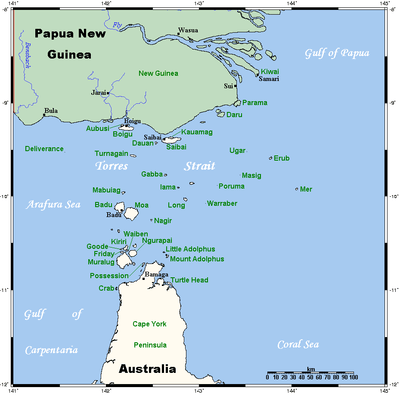
The islands span an area of some 48 000 km2. The strait from Cape York to New Guinea has a width of approximately 150 kilometres (93 mi) at its narrowest point; the islands lie scattered in between, extending some 200–300 km from furthest east to furthest west. The total land area of the islands comprises 566 km2.[11] 21,784 ha of land are used for agricultural purposes.[12]
The Torres Strait itself was formerly a land bridge which connected the present-day Australian continent with New Guinea (in a single landmass called Sahul or Australia-New Guinea). This land bridge was most recently submerged by rising sea levels at the termination of the last ice-age glaciation (approximately 12,000 years ago), forming the Strait which now connects the Arafura and Coral seas. Many of the western Torres Strait Islands are the remaining peaks of this land bridge which were not completely submerged when the ocean levels rose.
The islands and their surrounding waters and reefs provide a highly diverse set of land and marine ecosystems, with niches for many rare or unique species. Saltwater crocodiles inhabit the islands along with neighboring areas of Queensland and Papua New Guinea. Marine animals of the islands include dugongs (an endangered species of sea mammal widely found throughout the Indian Ocean and tropical Western Pacific, including Papua-New Guinean and Australian waters), as well as green, ridley, hawksbill and flatback sea turtles.
The Torres Strait Islands may be grouped into five distinct clusters, which exhibit differences of geology and formation as well as location. The Torres Strait provides a habitat for numerous birds, including the Torresian imperial-pigeon, which is seen as the iconic national emblem to the islanders.
These islands are also a distinct physiographic section of the larger Cape York Platform province, which in turn is part of the larger East Australian Cordillera physiographic division.
Top Western islands
The islands in this cluster lie very close to the southwestern coastline of New Guinea (the closest is less than 4 kilometres (2.5 mi) offshore). Saibai (one of the largest of the Torres Strait Islands) and Boigu are low-lying islands which were formed by deposition of sediments and mud from New Guinean rivers into the Strait accumulating on decayed coral platforms. Vegetation on these islands mainly consists of mangrove swamps, and they are prone to flooding.
The other main island in this group, Dauan (Mt Cornwallis), is a smaller island with steep hills, composed largely of granite. This island actually represents the northernmost extent of the Great Dividing Range, the extensive series of mountain ranges which runs along almost the entire eastern coastline of Australia. This peak became an island as the ocean levels rose at the end of the last ice age.
Near Western islands
The islands in this cluster lie south of the Strait's midway point, and are also largely high granite hills with mounds of basaltic outcrops, formed from old peaks of the now submerged land bridge. Moa (Banks Island) is the second-largest in the Torres Strait, and Badu (Mulgrave Island) is slightly smaller and fringed with extensive mangrove swamps. Other smaller islands include Mabuiag, Pulu and further to the east Naghir (correct form Nagi) (Mt. Ernest), though Nagi is culturally and linguistically a Central Island. Culturally this was the most complex part of Torres Strait, containing three of the four groupings/dialects of the Western-central Islanders, Nagi being culturally/linguistically a Central Island (Kulkalaig territory, specifically art of Waraber tribal waters), Moa is part of the Muwalaig-Italaig-Kaiwalaig [Kauraraig/Kaurareg] tribal areas, with two groups, the Italaig of the south, and the Muwalaig of the north. Many Kauraraig also live there, having been forcibly moved there in 1922-1923. Badu and Mabuiag are the Maluigal Deep Sea People.
Inner islands
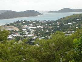
These islands, also known as the Thursday Island group, lie closest to Cape York Peninsula, and their topography and geological history is very similar. Muralag (Prince of Wales Island) is the largest of the Strait's islands, and forms the centre of this closely grouped cluster. The much smaller Waiben Thursday Island is the region's administrative centre and most heavily populated. Several of these islands have permanent freshwater springs, and some were also mined for gold in the late 19th and early 20th centuries. Because of their proximity to the Australian mainland, they have also been centres of pearling and fishing industries. Nurupai Horn Island holds the region's airport, and as a result is something of an entrepôt with inhabitants drawn from many other communities. Kiriri (Hammond Island) is the other permanently settled island of this group; Tuined (Possession Island) is noted for Lt. James Cook's landing there in 1770. Moa in the Near Western group is culturally and linguistically speaking part of this group.
Central islands
This cluster is more widely distributed in the middle of Torres Strait, consisting of many small sandy cays surrounded by coral reefs, similar to those found in the nearby Great Barrier Reef. The more northerly islands in this group however, such as Gerbar (Two Brothers) and Iama (Yam Island), are high basaltic outcrops, not cays. Culturally-speaking, Nagi of the Near-Western group is also part of this group, and also has high basaltic outcropping. The low-lying inhabited coral cays, such as Poruma (Coconut Island), Warraber Island and Masig (Yorke Island) are mostly less than 2 to 3 kilometres (1.2–1.9 miles) long, and no wider than 800 metres (2,600 feet). Several have had problems with saltwater intrusion.
Eastern islands
The islands of this group (principally Mer (Murray Island), Dauar and Waier, with Erub Island and Stephen Island (Ugar) further north) are formed differently from the rest. They are volcanic in origin, the peaks of volcanoes which were formerly active in Pleistocene times. Consequently, their hillsides have rich and fertile red volcanic soils, and are thickly vegetated. The easternmost of these are less than 20 kilometres (12 mi) from the northern extension of the Great Barrier Reef.
Administration

Regional Authority
An Australian Commonwealth statutory authority called the Torres Strait Regional Authority (TSRA) is responsible for governance of the islands. The TSRA has an elected board comprising 20 representatives from the Torres Strait Islander and Aboriginal communities resident in the Torres Strait region.
There is one representative per established local community. These board members are elected under the Queensland Community Services (Torres Strait) Act 1984 and Division 5 of the ATSIC Act 1989. The TSRA itself falls under the portfolio responsibilities of the Australian Government Department of the Prime Minister and Cabinet (previously under the Department of Families, Community Services and Indigenous Affairs). The administrative centre of the islands is Thursday Island.
The TSRA now represents the local communities at both Commonwealth and State levels – previously State representation was via a (closed since March 2008) Queensland statutory authority called the Island Coordinating Council (ICC). The ICC was superseded by the Torres Strait Island Region local government area.[13]
Local (shire) level government
At the local level there are two authorities, the Shire of Torres which governs several islands and portions of Cape York Peninsula and operates as a Queensland local government area. The Torres Strait Island Region, created in 2008, is the embodiment of 15 former island councils, these areas have been relinquished by the Government of Queensland to specific Islander and Aboriginal Councils under the provisions of the Community Services (Torres Strait) Act 1984 and the Community Services (Aboriginal) Act 1984.
|
|
|
|
Independence movement
Notable politicians have declared support for independence, including Bob Katter and former Queensland Premier Anna Bligh, who in August 2011 wrote to Prime Minister Julia Gillard in support of Torres Strait Islands independence from Australia; Prime Minister Gillard said in October 2011 "her government will respectfully consider the Torres Strait's request for self-government". Other figures who have supported independence include Australian indigenous rights campaigner Eddie Mabo.[14][15][16]
Demographics
Torres Strait Islanders, the indigenous peoples of the islands, are predominantly Melanesians, culturally most akin to the coastal peoples of Papua New Guinea. Thus they are regarded as being distinct from other Aboriginal peoples of Australia, and are generally referred to separately despite ongoing historical trade and inter-marriage with mainland Aboriginal people. There are also two Torres Strait Islander communities on the nearby coast of the mainland, Bamaga and Seisia.
According to the 2011 Australian census figures, the population of the Torres Strait Islands was 4,248, of whom 3,856 were Torres Strait Islanders.[1]
There are two indigenous languages spoken on the islands: the Western-Central Torres Strait Language (called by various names, including Kalaw Lagaw Ya, Kalaw Kawaw Ya, Kulkalgau Ya and Kaiwaligau Ya (Kowrareg)), and the Eastern Torres Language Meriam Mir. One language, Torres Strait Creole, or Brokan / Yumplatok, is used throughout Torres Strait, in neighbouring Papua as far as the West Papuan border area, and Cape York, as well as in many Island communities in Mainland Australia. This is a creole English similar to the closely related Tok Pisin in Papua New Guinea.
According to the Torres Strait Treaty, residents of Papua New Guinea are permitted to visit the Torres Strait Islands for traditional purposes.[17] In 2011, the Department of Foreign Affairs and Trade had to place restrictions on visitors to ensure water supply for local residents was adequate.
Climate change
The Torres Strait Islands are threatened by rising sea levels, especially those islands which do not rise more than one metre (3.3 feet) above sea level.[18] Storm surge and high tides pose the greatest danger. Other developing problems include erosion, property damage, drinking water contamination and the unearthing of the dead.[19] As of June 2010, there were no relocation strategies in place for Torres Strait Islanders.[19]
Disease control
The banana plant leaf disease black sigatoka, the major banana disease worldwide, is endemic to Papua New Guinea and the Torres Strait Islands. Occasional infections have been discovered on Cape York Peninsula but they have been successfully halted with eradication programs. The disease most likely appeared on the mainland via plant material from the Torres Strait Islands.[20]
See also
References
- 1 2 Australian Bureau of Statistics (31 October 2012). "Torres Strait Islands". 2011 Census QuickStats. Retrieved 19 June 2014.
- ↑ Suellen Hinde (31 January 2011). "Monster tides smother Torres Strait islands". The Sunday Mail. News Queensland. Retrieved 3 July 2011.
- ↑ Kirsty Nancarrow (5 December 2011). "Council makes bid for $5m seawalls revamp". ABC News. Australian Broadcasting Corporation. Retrieved 6 December 2011.
- ↑ John Burton. "History of Torres Strait to 1879 – a regional view". Torres Strait Regional Authority. Retrieved 3 July 2011.
- ↑ National Film and Sound Archive: The Recordings of the Cambridge Anthropological Expedition to Torres Straits on the Sounds of Australia registry
- ↑ Aboriginals Protection and Restriction of the Sale of Opium Act 1897 (Qld). Documenting Democracy. 24 May 2011. Retrieved on 3 July 2011.
- ↑ "The Border Problem". National Film and Sound Archive. Retrieved 12 June 2016.
- ↑ Matt Wordsworth (14 August 2013). "Patrolling the short hop from PNG to Australia". Australian Broadcasting Corporation. Retrieved 12 June 2016.
- ↑ For a detailed map see "Australia's Maritime Zones in the Torres Strait" (PDF). Australian Government – Geoscience Australia. Retrieved 2008-04-13.,
for the agreement see "Treaty between Australia and the Independent State of Papua New Guinea concerning sovereignty and maritime boundaries in the area between the two countries, including the area known as Torres Strait, and related matters, 18 December 1978" (PDF). United Nations. Retrieved 2008-04-13. - ↑ "Indigenous people still battle for land rights: activist". ABC News Online. Australian Broadcasting Corporation. 3 June 2007. Retrieved 3 July 2011.
- ↑ "Soils – Torres Strait Islands". Australian Natural Resources Atlas. Department of Sustainability, Environment, Water, Population and Communities. 6 May 2009. Retrieved 4 July 2011.
- ↑ "Economics – Torres Strait Islands". Australian Natural Resources Atlas. Department of Sustainability, Environment, Water, Population and Communities. 6 November 2007. Retrieved 4 July 2011.
- ↑ Torres Strait Flag. Torres Strait Regional Authority.
- ↑ Sarah Elks (15 October 2011). For Mabo's sake, let my island home go: Torres Strait elder George Mye. The Australian. News Limited. Retrieved on 25 April 2012.
- ↑ Larine Statham (17 October 2011). Progress for Torres Strait independence. Courier Mail. Queensland Newspapers. Retrieved on 25 April 2012.
- ↑ (5 August 2009). MP supports Torres Strait independence. news.com.au. News Limited. Retrieved on 25 April 2012.
- ↑ "Access to Outer Islands' water restricted". Torres News Online. 17 June 2011. Retrieved 3 July 2011.
- ↑ Peter Michael (2 August 2007). "Rising seas threat to Torres Strait islands". The Courier-Mail. News Queensland. Retrieved 3 July 2011.
- 1 2 Sofia Levin (28 June 2010). "Climate change: not all black and white". Australian Broadcasting Corporation. Retrieved 3 July 2011.
- ↑ Peterson, R.; K. Grice; R. Goebel (December 2005). "Eradication of black leaf streak disease from Banana-growing regions in Australia". InfoMusa. 14 (2): 7–10. Retrieved 2011. Check date values in:
|access-date=(help)
External links
| Wikimedia Commons has media related to Torres Strait Islands. |
| Wikivoyage has a travel guide for Torres Strait Islands. |
- Torres Strait Regional Authority
- Torres Shire Council
- Torres Strait community government review
- Torres Strait Islands info page at abc.net
- Photograph album of Papua and Torres Strait (1921) taken by Frank Hurley. Held National Library of Australia, Canberra
- Torres Strait Atlas
Coordinates: 9°52′49″S 142°35′26″E / 9.88028°S 142.59056°E
List of Torres Strait topics | |||||||||||||||||||||||||||||||||||
|---|---|---|---|---|---|---|---|---|---|---|---|---|---|---|---|---|---|---|---|---|---|---|---|---|---|---|---|---|---|---|---|---|---|---|---|
| Torres Strait Islands, islets, and cays |
| ||||||||||||||||||||||||||||||||||
| People, culture, communities and languages |
| ||||||||||||||||||||||||||||||||||
| Governance and legal matters |
| ||||||||||||||||||||||||||||||||||
| Buildings and structures | |||||||||||||||||||||||||||||||||||
| Other | |||||||||||||||||||||||||||||||||||