Gabba Island
"Gerbar Island" redirects here. For the Tunisian island formerly known as "Gerba", see Djerba.
| Native name: <span class="nickname" ">Gerbar | |
|---|---|
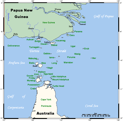 A map of the Torres Strait Islands showing Gabba Island in the northern central waters of Torres Strait | |
| Geography | |
| Location | Northern Australia |
| Coordinates | 9°45′54″S 142°37′39″E / 9.76500°S 142.62750°ECoordinates: 9°45′54″S 142°37′39″E / 9.76500°S 142.62750°E |
| Archipelago | Torres Strait Islands |
| Adjacent bodies of water | Torres Strait |
| Administration | |
| State | Queensland |
| Demographics | |
| Population | Uninhabited |
Gabba Island, or Gerbar in the native language, is an Australian island situated in the Torres Strait, and north-west of Yam Island. It is part of the Torres Strait Islands, and is uninhabited except for wild pigs.
The first recorded sighting by Europeans was by the Spanish expedition of Luís Vaez de Torres on 10 September 1606.[1]
The Newton, a 15-long-ton (15 t) ketch, was foundered and shipwrecked off Gabba Island in December 1913.
References
- ↑ Hilder, Brett The voyage of Torres, Brisbane, 1980, pp.78,80
List of Torres Strait topics | |||||||||||||||||||||||||||||||||||
|---|---|---|---|---|---|---|---|---|---|---|---|---|---|---|---|---|---|---|---|---|---|---|---|---|---|---|---|---|---|---|---|---|---|---|---|
| Torres Strait Islands, islets, and cays |
| ||||||||||||||||||||||||||||||||||
| People, culture, communities and languages |
| ||||||||||||||||||||||||||||||||||
| Governance and legal matters |
| ||||||||||||||||||||||||||||||||||
| Buildings and structures | |||||||||||||||||||||||||||||||||||
| Other | |||||||||||||||||||||||||||||||||||
This article is issued from Wikipedia - version of the 11/24/2016. The text is available under the Creative Commons Attribution/Share Alike but additional terms may apply for the media files.