Trochus Island
|
Trochus Island (left) with Turtle Head Island (centre) | |
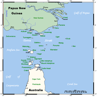 A map of the Torres Strait Islands showing Turtle Head Island in the south eastern waters of Torres Strait, east of the Cape York Peninsula | |
| Geography | |
|---|---|
| Location | Great Barrier Reef Marine Park, Northern Australia |
| Coordinates | 10°55′19″S 142°37′48″E / 10.922°S 142.630°ECoordinates: 10°55′19″S 142°37′48″E / 10.922°S 142.630°E |
| Archipelago | Torres Strait Islands |
| Adjacent bodies of water | Torres Strait |
| Area | 2.10 km2 (0.81 sq mi)[1] |
| Administration | |
| State | Queensland |
| Local government area | Shire of Torres |
| Demographics | |
| Ethnic groups | Torres Strait Islanders |
.jpg)
Trochus Island is an island of the Torres Strait Islands archipelago, located in the Great Barrier Reef Marine Park, east of Cape York Peninsula, in Queensland, Australia.
The island is located in Newcastle Bay at the mouth of Escape River and Middle River, not far from Jackey Jackey Creek and adjacent to the Jardine River National Park. The island lies approximately 30 km (19 mi) southeast of Bamaga and has an approximate area of 2.1 square kilometres (0.81 sq mi).[1]
Gallery

See also
References
- 1 2 "Map of Trochus Island, QLD". Bonzle Digital Atlas of Australia.
List of Torres Strait topics | |||||||||||||||||||||||||||||||||||
|---|---|---|---|---|---|---|---|---|---|---|---|---|---|---|---|---|---|---|---|---|---|---|---|---|---|---|---|---|---|---|---|---|---|---|---|
| Torres Strait Islands, islets, and cays |
| ||||||||||||||||||||||||||||||||||
| People, culture, communities and languages |
| ||||||||||||||||||||||||||||||||||
| Governance and legal matters |
| ||||||||||||||||||||||||||||||||||
| Buildings and structures | |||||||||||||||||||||||||||||||||||
| Other | |||||||||||||||||||||||||||||||||||
This article is issued from Wikipedia - version of the 7/27/2016. The text is available under the Creative Commons Attribution/Share Alike but additional terms may apply for the media files.