Acidalia Planitia
|
Topography | |
| Coordinates | 49°48′N 339°18′E / 49.8°N 339.3°ECoordinates: 49°48′N 339°18′E / 49.8°N 339.3°E |
|---|---|

Acidalia Planitia is a plain on Mars. It is located between the Tharsis volcanic province and Arabia Terra to the north of Valles Marineris, centered at 49°48′N 339°18′E / 49.8°N 339.3°E.[1] Most of this region is found in the Mare Acidalium quadrangle, but a small part is in the Ismenius Lacus quadrangle. The plain contains the famous Cydonia region at the contact with the heavily cratered highland terrain.
The plain is named after a corresponding albedo feature on a map by Giovanni Schiaparelli, which was in turn named after the mythological fountain of Acidalia. Some places in Acidalia Planitia show cones. Some researchers have suggested that these are mud volcanoes.
Gullies
Martian gullies are small, incised networks of narrow channels and their associated downslope sediment deposits, found on the planet of Mars. They are named for their resemblance to terrestrial gullies. First discovered on images from Mars Global Surveyor, they occur on steep slopes, especially on the walls of craters. Usually, each gully has a dendritic alcove at its head, a fan-shaped apron at its base, and a single thread of incised channel linking the two, giving the whole gully an hourglass shape.[2] They are believed to be relatively young because they have few, if any craters. A subclass of gullies is also found cut into the faces of sand dunes which themselves considered to be quite young. On the basis of their form, aspects, positions, and location amongst and apparent interaction with features thought to be rich in water ice, many researchers believed that the processes carving the gullies involve liquid water. However, this remains a topic of active research.
-

Context for next image of Bamberg crater. Box shows where the next image came from. This is a CTX image from Mars Reconnaissance Orbiter.
-

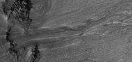
Gullies and massive flow of material, as seen by HiRISE under HiWish program. Gullies are enlarged in next two images. Location is Bamberg crater.
-

Close up view of some gullies, as seen by HiRISE under the HiWish program.
-
Close up view of another gully in same HiRISE picture. Picture taken under HiWish program.
-
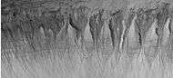
Gullies, as seen by HiRISE under HiWish program.
-

Gullies in a crater, as seen by HiRISE under HiWish program.
-
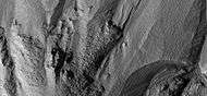
Close-up of gullies in a crater from previous image. Image taken by HiRISE under HiWish program. Polygons are easily visible; they are believed to be from the freezing and thawing of ice in the ground.
Mud volcanoes
-

Possible mud volcanoes near the edge of the ejecta of a nearby crater, as seen by HiRISE under the HiWish program.
-

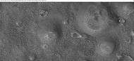
Large field of cones that may be mud volcanoes, as seen by HiRISE under HiWish program
-
Close-up of possible mud volcanoes, as seen by HiRISE under HiWish program Note: this is an enlargement of the previous image.
-

Possible mud volcano, as seen by HiRISE under HiWish program
Other images
-

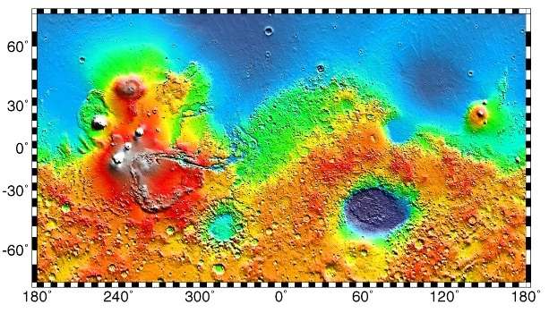
MOLA map showing boundaries for Acidalia Planitia and other regions
-

The Martian (2015 film)
Ares III Mission - Landing site
(Acidalia Planitia region)
In popular culture
In the 2011 novel The Martian by Andy Weir, and its 2015 film adaptation, Acidalia Planitia is the landing site of the Ares III mission, where the protagonist is stranded following a dust storm.[3]
Interactive Mars map
See also
References
- ↑ "Acidalia Planitia". Gazetteer of Planetary Nomenclature. USGS Astrogeology Science Center. Retrieved 2015-03-10.
- ↑ Malin, M., Edgett, K. 2000. Evidence for recent groundwater seepage and surface runoff on Mars. Science 288, 2330–2335.
- ↑ Weir, Andy (2014). The Martian. New York: Crown Publishers. ISBN 978-0-8041-3902-1.
External links
| Wikimedia Commons has media related to Acidalia Planitia. |