2015–16 South-West Indian Ocean cyclone season
| |
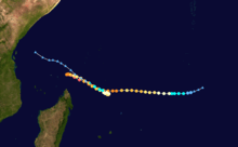
| Season summary map |
| First system formed |
November 19, 2015 |
| Last system dissipated |
April 23, 2016 |
| Strongest storm1 |
Fantala – 910 hPa (mbar), 250 km/h (155 mph) (10-minute sustained) |
| Total disturbances |
8 |
| Total depressions |
8 |
| Total storms |
8 |
| Tropical cyclones |
3 |
| Intense tropical cyclones |
3 |
| Very intense tropical cyclones |
1 |
| Total fatalities |
13 total |
| Total damage |
$4.5 million (2016 USD) |
| 1Strongest storm is determined by lowest pressure |
South-West Indian Ocean tropical cyclone seasons
2013–14, 2014–15, 2015–16, 2016–17, 2017–18 |
| Related articles |
|
|
The 2015–16 South-West Indian Ocean cyclone season was a slightly below average season of tropical cyclone formation in the Southwest Indian Ocean. The annual cyclone season began on November 15, 2015, with the first storm, Annabelle, forming four days following. The final and strongest storm, Fantala, dissipated on April 24, 2016, though the season ended on April 30, with the exception of Mauritius and the Seychelles, where it ended on May 15. The season's activity was influenced by an ongoing El Nino, and a positive Indian Ocean Dipole.
The basin consists of the portion of the Indian Ocean west of 90°E and south of the Equator. Activity was monitored by Météo-France, the Regional Specialized Meteorological Centre in the basin. The basin is unofficially monitored by the Joint Typhoon Warning Center, which uses one-minute sustained winds and the Saffir-Simpson Hurricane Wind Scale, while Météo-France uses ten-minute sustained winds and its own scale.
Most systems of the season remained weak, with only three cyclones reaching at least tropical cyclone strength. However, the season featured Very Intense Tropical Cyclone Fantala, which became the strongest cyclone on record in the basin in terms of 10-minute sustained winds at 250 km/h (155 mph).
Seasonal outlook
On October 19, the Mauritius Meteorological Services (MMS) released their summer 2015–16 outlook. An average season, with around seven to nine cyclones forming, was expected. MMS also indicated that the equatorial region to the north of Mauritius, east of Agaléga and west of Diego Garcia, could be significantly conducive for cyclone formation.[1]
Seasonal summary
The season started on November 19, with the formation of Annabelle. After a month of inactivity, Bohale formed, but was fairly weak, and only reached moderate tropical cyclone strength. Another month passed before Corentin formed on January 20. The basin became somewhat active with Daya forming, and Uriah entering the basin in February, the climatological most active month of the season. Emeraude formed in March, quickly peaking at intense tropical cyclone strength, before quickly weakening. Also, an unmonitored tropical depression entered the basin, but became extratropical soon after. Tropical Cyclone 07 formed at the end of March. The storm was operationally declared a depression, but was upgraded in post-storm analysis to a moderate tropical cyclone. In April, the season began to wind down. Very Intense Tropical Cyclone Fantala formed near the end of the month, and reached peak intensity as the strongest tropical cyclone of the basin in terms of sustained winds. Fantala dissipated on April 24, ending the season.
Storms
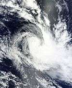
Severe Tropical Storm Annabelle
| Severe tropical storm (MFR) |
| Tropical storm (SSHWS) |
|
|
| Duration |
November 19 – November 24 |
| Peak intensity |
100 km/h (65 mph) (10-min) 986 hPa (mbar) |
Moderate Tropical Storm Bohale
| Moderate tropical storm (MFR) |
| Tropical storm (SSHWS) |
|
|
| Duration |
December 8 – December 13 |
| Peak intensity |
65 km/h (40 mph) (10-min) 996 hPa (mbar) |
Severe Tropical Storm Corentin
| Severe tropical storm (MFR) |
| Category 1 tropical cyclone (SSHWS) |
|
|
| Duration |
January 20 – January 25 |
| Peak intensity |
110 km/h (70 mph) (10-min) 970 hPa (mbar) |
Moderate Tropical Storm Daya
| Moderate tropical storm (MFR) |
| Tropical storm (SSHWS) |
|
|
| Duration |
February 8 – February 12 |
| Peak intensity |
75 km/h (45 mph) (10-min) 992 hPa (mbar) |
Between February 9 and 10, heavy rain from Daya affected parts of Madagascar, Réunion, and Mauritius. During a 24-hour period, 111 mm (4.4 in) of rain fell in Vacoas-Phoenix, Mauritius, and 100 mm (3.9 in) fell in Saint-Denis, Réunion. Flash flooding damaged homes and displaced hundreds of people in Mauritius.[2]
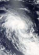
Intense Tropical Cyclone Uriah
| Intense tropical cyclone (MFR) |
| Category 4 tropical cyclone (SSHWS) |
|
|
| Duration |
February 14 (Entered basin) – February 19 |
| Peak intensity |
205 km/h (125 mph) (10-min) 925 hPa (mbar) |
On February 14, RSMC La Reunion reported that Tropical Cyclone Uriah had entered the basin, and it immediately classified the system as a severe tropical storm.
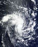
Intense Tropical Cyclone Emeraude
| Intense tropical cyclone (MFR) |
| Category 4 tropical cyclone (SSHWS) |
|
|
| Duration |
March 15 – March 21 |
| Peak intensity |
205 km/h (125 mph) (10-min) 940 hPa (mbar) |
Moderate Tropical Storm 07
| Moderate tropical storm (MFR) |
| Tropical storm (SSHWS) |
|
|
| Duration |
March 28 – March 30 |
| Peak intensity |
85 km/h (50 mph) (10-min) 992 hPa (mbar) |
On March 28, JTWC reported that Tropical Cyclone 17S had developed about 575 mi (925 km) to the south-southeast of Diego Garcia, while Mauritius Meteorological Services noted 17S as a non-significant tropical disturbance.[3] Moderate Tropical Storm 07 was operationally classified as a Tropical Depression by Mauritius Meteorological Services, but after post-storm analysis discovered 10-min sustained wind speeds of 50 miles per hour during its peak and classified the cyclone as a Moderate Tropical Storm.
Very Intense Tropical Cyclone Fantala
| Very intense tropical cyclone (MFR) |
| Category 5 tropical cyclone (SSHWS) |
|
|
| Duration |
April 11 – April 23 |
| Peak intensity |
250 km/h (155 mph) (10-min) 910 hPa (mbar) |
Fantala formed on April 11 to the south of Diego Garcia.[4] With a ridge to the south, the storm moved westward for several days while gaining strength, aided by warm waters and decreasing wind shear.[5][6] Late on April 17, the MFR estimated peak 10-minute sustained winds of 250 km/h (155 mph), the highest on record in the basin.[7] Meanwhile, the JTWC estimated peak 1-minute sustained winds of 280 km/h (175 mph), tied only with Cyclone Agnielle from November 1995 as the strongest cyclone on record in the south-west Indian Ocean.[8][9] The system weakened due to an eyewall replacement cycle, and a change of steering currents caused Fantala to reverse direction and accelerate southeast. This brought the cyclone over cooler waters previously upwelled by itself, causing further weakening. Between April 19 and 23, Fantala fluctuated in intensity. At first, the eye became more pronounced,[10] but wind shear soon caused weakening to resume. By April 22, Fantala stalled again due to a building ridge to its south. Fantala accelerated back northwest as a moderate tropical cyclone, with the JTWC and MFR issuing their final advisories on April 24. The remnants of Fantala continued northwest.
While near peak intensity, Fantala passed near the Farquhar Group of the Seychelles, damaging most of the buildings in the small archipelago.[11]
Storm names
Within the South-West Indian Ocean, tropical depressions and subtropical depressions that are judged to have 10-minute sustained wind of at least 65 km/h (40 mph) by the Regional Specialized Meteorological Center on La Réunion Island, France (RSMC La Réunion) are usually assigned a name. However, it is the Sub-Regional Tropical Cyclone Advisory Centers in Mauritius and Madagascar who name the systems. The Sub-Regional Tropical Cyclone Advisory Center in Mauritius names a storm should it intensify into a moderate tropical storm between 55°E and 90°E. If a storm should intensify into a moderate tropical storm between 30°E and 55°E then the Sub-Regional Tropical Cyclone Advisory Center in Madagascar assigns the appropriate name to the storm. New name lists are used every year, and a name is normally only used once, so there are currently no retired names, however should a name go unused during a season, the name could be re-used in future seasons.[12]
- Annabelle
- Bohale
- Corentin
- Daya
- Emeraude
- Fantala
- Gao (unused)
- Hassina (unused)
- Inacio (unused)
|
- Juma (unused)
- Ketiwe (unused)
- Lalelani (unused)
- Moabi (unused)
- Naima (unused)
- Octave (unused)
- Piera (unused)
- Quizito (unused)
- Richard (unused)
|
- Sofia (unused)
- Tatiana (unused)
- Umboni (unused)
- Vela (unused)
- Wayne (unused)
- Xaba (unused)
- Yazid (unused)
- Zenani (unused)
|
Seasonal effects
This table lists all of the tropical cyclones and subtropical cyclones that were monitored during the 2015–2016 South-West Indian Ocean cyclone season. Information on their intensity, duration, name, areas affected, primarily comes from RSMC La Réunion. Death and damage reports come from either press reports or the relevant national disaster management agency while the damage totals are given in 2015 or 2016 USD.
See also
References
- ↑ "Summer 2015–2016 Outlook for Mauritius and Rodrigues". Mauritius Meteorological Services. October 19, 2015. Archived from the original on October 20, 2015. Retrieved October 20, 2015.
- ↑ "Madagascar, La Reunion, Mauritius - Tropical Cyclone Daya: ECHO Daily Flash of 11 February 2016". ReliefWeb. European Commission Humanitarian Aid Office. February 11, 2016. Retrieved February 14, 2016.
- ↑ Mauritius meteological services. "METAREA8S / HIGH_SEAS_FORECAST / 1232". Global Maritime Distress and Safety System. Archived from the original on March 28, 2016. Retrieved 2016-03-29.
- ↑ Tropical Disturbance 8 Warning 1. Météo-France (Report). National Oceanic and Atmospheric Administration. April 11, 2016. Archived from the original on April 11, 2016. Retrieved April 21, 2016.
- ↑ "Tropical Cyclone 19S (Fantala) Warning NR 008". Joint Typhoon Warning Center. April 15, 2016. Archived from the original on April 15, 2016. Retrieved April 21, 2016.
- ↑ Intense Tropical Cyclone 8 (Fantala) Warning 18. Météo-France (Report). National Oceanic and Atmospheric Administration. April 15, 2016. Archived from the original on April 15, 2016. Retrieved April 21, 2016.
- ↑ Very Intense Tropical Cyclone 8 (Fantala) Warning 27. Météo-France (Report). National Oceanic and Atmospheric Administration. April 17, 2016. Archived from the original on April 17, 2016. Retrieved April 21, 2016.
- ↑ "Tropical Cyclone 19S (Fantala) Warning NR 013". Joint Typhoon Warning Center. April 17, 2016. Archived from the original on April 18, 2016. Retrieved April 21, 2016.
- ↑ Max Bearak (April 19, 2016). "A humongous, El Niño-fueled cyclone named Fantala is this year's third record-breaker in a row". The Washington Post. Retrieved April 21, 2016.
- ↑ Very Intense Tropical Cyclone 8 (Fantala) Warning 32. Météo-France (Report). National Oceanic and Atmospheric Administration. April 19, 2016. Archived from the original on April 19, 2016. Retrieved April 21, 2016.
- ↑ Sharon Urinie (April 20, 2016). "Seychelles authorities declare Farquhar islands disaster areas after Cyclone Fantala hits twice". Seychelles News Agency. Retrieved April 21, 2016.
- ↑ Regional Association I Tropical Cyclone Committee (2010). "Tropical Cyclone Operational Plan for the South-West Indian Ocean" (PDF). World Meteorological Organization. Retrieved 2012-06-07.
External links
|
|---|
|
| |
|
-
 Book Book
-
 Category Category
-
 Portal Portal
-
 WikiProject WikiProject
-
 Commons Commons
|