1977 Atlantic hurricane season
 | |
| Season summary map | |
| First system formed | June 13, 1977 |
|---|---|
| Last system dissipated | November 7, 1977 |
| Strongest storm1 | Anita – 926 mbar (hPa) (27.35 inHg), 175 mph (280 km/h) (1-minute sustained) |
| Total depressions | 16 |
| Total storms | 6 |
| Hurricanes | 5 |
| Major hurricanes (Cat. 3+) | 1 |
| Total fatalities | 11 |
| Total damage | $13 million (1977 USD) |
| 1Strongest storm is determined by lowest pressure | |
1975, 1976, 1977, 1978, 1979 | |
The 1977 Atlantic hurricane season had the fewest tropical storms since the 1965 season. The season officially began on June 1, and lasted until November 30. These dates conventionally delimit the period of each year when most tropical cyclones form in the Atlantic basin. The first tropical depression of the season developed on June 13, 12 days after the start of the season, in the western Caribbean Sea. After a succession of three other tropical depressions, the first tropical storm of the season, Hurricane Anita, finally became a named storm on August 29 – the latest date since the satellite era began in the 1960s.[1] Anita struck Mexico as a Category 5 hurricane on the Saffir–Simpson hurricane wind scale, bringing strong winds and heavy rainfall. At least 25,000 people were left homeless and 11 fatalities were reported.
In addition to Anita, another notable tropical cyclone of this season was Hurricane Babe. The storm caused coastal flooding in southeastern Louisiana, resulting in $10 million (1977 USD) in damage.[nb 1] After moving inland, it spawned 14 tornadoes throughout Alabama, Louisiana, Mississippi, and South Carolina. In addition to Anita and Babe, five other tropical cyclones – hurricanes Clara, Dorothy, and Evelyn, as well as Tropical Storm Frieda and Tropical Depression Nine – left only minor impacts on land. Overall, the tropical cyclones of the season collectively caused 11 fatalities and at least $13 million in damage, excluding the remnants of Tropical Depression Nine, which led to 53 deaths and $203 million in losses due to flooding in the Southeastern United States, New Jersey, and New York.
Season summary
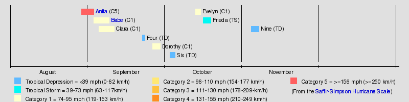
The Atlantic hurricane season officially began on June 1, 1977.[2] Activity began several days later with the formation of a tropical depression on June 13. Although 16 tropical depressions formed, it was a below average season because only 6 of them strengthened into tropical storms.[3] In terms of named storms, this was the least active season since 1965.[4] Five of these attained hurricane status. In addition, one tropical cyclone eventually attained major hurricane status,[3] which is Category 3 or higher on the Saffir–Simpson hurricane wind scale.[4] The inactivity was attributed to a El Niño that began developing in August.[5] Three hurricanes and one tropical storm made landfall during the season, causing 11 deaths and $13 million in damage.[6][7][8] The last storm of the season, Tropical Depression Thirteen, dissipated on November 7,[3] over three weeks before the official end of the season on November 30.[2]
Tropical cyclogenesis in the 1977 Atlantic hurricane season began with the development of a tropical depression on June 13. Activity briefly halted, until two other tropical depression developed in the second half of July. A fourth tropical depression formed in early August.[3] Later that month, Hurricane Anita developed on August 29. As September is the climatological peak of hurricane season, it was the most active month.[7] Five tropical cyclones developed, including two tropical depressions,[3] and hurricanes Babe, Clara, and Dorothy.[7] There were also five tropical cyclone in October – three tropical depressions,[3] Hurricane Evelyn, and Tropical Storm Frieda.[7] The final tropical cyclone of the season, Tropical Depression Nine, developed between the Greater Antilles and Bermuda on November 3 and dissipated by November 7.[3]
The season's activity was reflected with a cumulative accumulated cyclone energy (ACE) rating of 25, which was the lowest ACE value since 1946.[4] ACE is, broadly speaking, a measure of the power of the hurricane multiplied by the length of time it existed, so storms that last a long time, as well as particularly strong hurricanes, have high ACEs. ACE is only calculated for full advisories on tropical systems at or exceeding 34 knots (39 mph, 63 km/h) or tropical storm strength. Subtropical storms are not included, therefore, the subtropical stage of Babe is omitted from the total ACE value.[9]
Storms
Hurricane Anita
| Category 5 hurricane (SSHWS) | |||
|---|---|---|---|
| |||
| Duration | August 29 – September 3 | ||
| Peak intensity | 175 mph (280 km/h) (1-min) 926 mbar (hPa) | ||


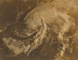
A tropical wave spawned a tropical depression at 1200 UTC on August 29, while located about 230 miles (370 km) south-southwest of New Orleans, Louisiana.[3][7] The depression moved west-southwestward and strengthened into Tropical Storm Anita early on August 30. Later that day, the storm had intensified into a hurricane. Although intensification briefly slowed, rapid deepening occurred from September 1 to the following day, when Anita peaked as a Category 5 hurricane with winds of 175 mph (280 km/h).[3] The storm weakened slightly to a Category 4 hurricane before making landfall near Soto la Marina, Tamaulipas.[7] It rapidly weakened inland, decreasing to tropical depression intensity early on September 3. However, Anita remained intact across Mexico and reached the eastern Pacific Ocean as a depression.[3]
Prior to becoming a tropical cyclone, the precursor to Anita dropped light rainfall in Florida.[10] Gusty winds and storm surge effected Louisiana. At Grand Isle, storm tides 2 feet (0.61 m) above normal resulted in hundreds of families being asked to evacuate. Numerous coastal highways in Texas, including portions of State Highway 87, were closed due to above normal tides.[11] Precipitation reached 4.97 inches (126 mm) in Rio Grande City.[10] In Mexico, the hurricane caused strong winds and moderate rainfall.[7][12] The winds caused extensive damage to villages in northeastern Mexico, with about 25,000 people left homeless. The roofs of most buildings were destroyed near the location of Anita's landfall.[13] The highest amount of precipitation observed during the storm was 15.2 inches (390 mm) at Soto la Marina, Tamaulipas.[7] Flooding and mudslides killed eleven people in the state.[6] Overall damage is unknown.[7]
Hurricane Babe
| Category 1 hurricane (SSHWS) | |||
|---|---|---|---|
| |||
| Duration | September 3 – September 9 | ||
| Peak intensity | 75 mph (120 km/h) (1-min) 995 mbar (hPa) | ||

The interaction of a tropical wave and a cold upper low pressure area developed into a subtropical depression in the eastern Gulf of Mexico on September 3.[7][3] It strengthened while gradually acquiring tropical characteristics and was reclassified as Tropical Storm Babe late on September 4. The storm curved north-northeastward and by early on the following day, it was upgraded to a hurricane. Around that time, Babe peaked with maximum sustained winds of 75 mph (120 km/h). Early on September 5, Babe made landfall near Cocodrie, Louisiana at the same intensity. Later that day, it weakened to a tropical storm and then a tropical depression on September 6. However, Babe continued to move northeastward and then east-northeastward across the Southeastern United States until dissipating early on September 9.[3]
Babe produced light to moderate rainfall across much of the Southern United States. In Louisiana, precipitation peaked at 10.99 inches (279 mm) near Lafayette.[14] Flooding damage was primarily to crops, mainly sugar cane.[7] Six tornadoes were spawned in Louisiana, including one near Hammond that severely damage a country store and knocked six wood-frame homes off their foundations. Damage from this tornado alone reached $2.5 million.[8][15] In other states, Babe brought flash flooding along its path due to rainfall exceeding 7 inches (180 mm) in Mississippi, northwestern Georgia, and western North Carolina.[7] Overall, Babe caused about $13 million in damage, but no deaths.[8]
Hurricane Clara
| Category 1 hurricane (SSHWS) | |||
|---|---|---|---|
| |||
| Duration | September 5 – September 11 | ||
| Peak intensity | 75 mph (120 km/h) (1-min) 993 mbar (hPa) | ||

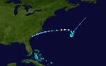
A convective cloud mass with a spiral band of gale-force winds, associated with the development of Hurricane Babe, moved across the Southeastern United States in early September. The system developed a circulation by late on September 4, while tracking across southeastern Georgia. After a slight drop in barometric pressure and an increase in wind speeds, a tropical depression formed inland near Charleston, South Carolina at 1200 UTC on September 5. The depression initially drifted east-northeastward and soon moved offshore. After passing south of Cape Hatteras, North Carolina on September 6, it began to organize while accelerating just north of due east. At 0000 UTC on September 8, the depression intensified into Tropical Storm Clara. The storm quickly strengthened, becoming a hurricane only 12 hours later.[16] Strong wind shear caused Clara to weaken back to a tropical storm on September 9. Thereafter, the storm executed a cyclonic loop near Bermuda. By late on September 10, Clara accelerated northeastward and became extratropical at 1200 UTC on September 11.[16]
In its early stages, the storm dropped light rainfall in the Southeastern United States, peaking at 3.53 inches (90 mm) in Beaufort, South Carolina.[17] Additionally, Clara produced 0.55 inches (14 mm) of precipitation in Bermuda.[18] The remnants reached Canada and produced winds of 62 mph (100 km/h) in Antigonish, Nova Scotia, which knocked over campers, uprooted trees, damaged barns, and caused power outages in the area.[19]
Hurricane Dorothy
| Category 1 hurricane (SSHWS) | |||
|---|---|---|---|
| |||
| Duration | September 26 – September 29 | ||
| Peak intensity | 85 mph (140 km/h) (1-min) 980 mbar (hPa) | ||

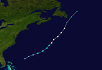
A tropical wave emerged into the Atlantic Ocean from the west coast of Africa on September 15. The system tracked westward at 17 to 23 mph (27 to 37 km/h) and convection began organizing five days later. On September 21, the wave crossed the Windward Islands, bringing wind gusts of 69 mph (111 km/h) to Guadeloupe and Martinique and rainfall of 5 to 8 inches (130 to 200 mm) on several islands. Although it was a strong tropical wave, the system weakened significantly while crossing Hispaniola on September 23. Tracking steadily northward, it developed into a tropical depression northeast of the Bahamas on September 26. A reconnaissance aircraft indicated that the depression strengthened into Tropical Storm Dorothy at 1200 UTC on September 27.[20]
Shortly after becoming a tropical storm, Dorothy passed just south of Bermuda, though no damage was reported on the island. The storm quickly strengthened while tracking northeastward and strengthened into a hurricane at 1200 UTC on September 28. By early on September 29, Dorothy attained its peak intensity with maximum sustained winds of 85 mph (140 km/h) and a minimum barometric pressure of 980 mbar (29 inHg). Later that day, Dorothy transitioned into an extratropical storm while located south of Cape Race, Newfoundland. On September 30, the extratropical remnants of Dorothy were absorbed by a frontal low pressure system located in the northern Atlantic Ocean.[20]
Hurricane Evelyn
| Category 1 hurricane (SSHWS) | |||
|---|---|---|---|
| |||
| Duration | October 13 – October 15 | ||
| Peak intensity | 80 mph (130 km/h) (1-min) 994 mbar (hPa) | ||


A tropical wave emerged into the Atlantic Ocean from the west coast of Africa on October 3. The system tracked westward at an abnormally low altitude of 6°N. However, because the Azores high pressure was abnormally weak, the system quickly curved northwestward. After a significant increase in convection, a tropical depression developed at 1800 UTC on October 13, while located 400 miles (640 km) south of Bermuda. A ship later reported gale force winds, prompting an upgrade of the depression to Tropical Storm Evelyn on October 14. Early on the following day, a reconnaissance flight recorded winds of 83 mph (134 km/h), indicating that Evelyn became a hurricane. Later on October 15, accelerated to the north-northeast and made landfall on Cape Breton Island, Nova Scotia with winds of 80 mph (130 km/h) at 1200 UTC. Shortly after entering the Gulf of Saint Lawrence, Evelyn merged with a cold front at 1800 UTC on October 15, near the tip of southeastern Newfoundland.[21]
Impact on Bermuda was limited to light winds[21] and a small amount of rainfall – 2.60 inches (66 mm).[18] On Sable Island, Evelyn produced tropical storm force winds, reaching 52 mph (84 km/h).[22] In both Nova Scotia and Newfoundland, the storm dropped light rainfall, rarely exceeding 1 inch (25 mm).[23] However, in Newfoundland, some areas experienced tropical storm force winds, mainly between Stephenville and St. John's.[21][23] However, this may have been in combination with the cold front that Evelyn merged with. In addition, a ship near the southwestern tip of Newfoundland reported sustained winds of 78 mph (126 km/h).[24]
Tropical Storm Frieda
| Tropical storm (SSHWS) | |||
|---|---|---|---|
| |||
| Duration | October 16 – October 19 | ||
| Peak intensity | 60 mph (95 km/h) (1-min) 1005 mbar (hPa) | ||
.JPG)

A tropical wave emerged into the Atlantic Ocean from the west coast of Africa on October 4. The wave tracked uneventfully westward for about 10 days. On October 12, the remnants of a cold front reached the northwestern Caribbean Sea. The wave began interacting with it and another cold front that entered the region by October 16. Later that day, a reconnaissance aircraft reported a surface circulation near Swan Island, Honduras.[7] Thus, a tropical depression developed at 1800 UTC on October 16. The depression moved slowly westward and strengthened into Tropical Storm Frieda on October 17, while passing south of Swan Island.[3]
Frieda continued to intensify until peaking with winds of 60 mph (95 km/h) and a minimum barometric pressure of 1,005 mbar (29.7 inHg) early on October 18. Later that day, Frieda weakened and fell to tropical depression intensity. At 0000 UTC on October 19, the storm made landfall near Belize City, Belize as a weak tropical depression. Frieda promptly dissipated.[3] Belize City reported only minimal rainfall and light winds. Around that time, the storm passed south of Swan Island, where it produced 4.46 inches (113 mm) in a 30‑hour period. On Grand Cayman, 5.42 inches (138 mm) of precipitation fell in 36 hours.[7]
Tropical Depression Nine
| Tropical depression (SSHWS) | |||
|---|---|---|---|
| |||
| Duration | November 3 – November 7 | ||
| Peak intensity | 35 mph (55 km/h) (1-min) 1006 mbar (hPa) | ||
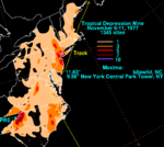
A tropical depression formed between the Greater Antilles and Bermuda on November 3. Initially, the depression moved northeastward, though on November 4, a building high pressure area forced it to track north of due west. Eventually, an upper-level low situated over the Southern United States caused the depression to re-curve north-northwestward. Late on November 7, the depression made landfall near Cape Lookout, North Carolina. By early on the following day, the depression degenerated into a low pressure area while located over eastern Virginia. The remnants continued northeastward across the Mid-Atlantic and New England, before being absorbed by an extratropical cyclone while offshore of Maine on November 11.[25]
Moisture from Tropical Depression Nine and a low pressure area that tracked across the Southeastern United States resulted in heavy rainfall over western North Carolina and western Virginia, with up to 11.63 inches (295 mm) at Idlewild in the former.[25] In North Carolina, flooding destroyed 384 homes, 382 miles (615 km) of highways, and 12 dams. Flooding was considered the worst in Yancey County, where nearly every bridge was washed out. Sixteen counties in the western portions of the state were declared disaster areas.[26] The depression also produced 5 to 9 inches (130 to 230 mm) of rainfall in northern Georgia. Eighteen bridges were destroyed and twenty-seven others were damaged. In Virginia, 100 homes were destroyed by flooding, with about the same amount suffering major damage. Similar impact was reported in Tennessee. Strong winds and storm tides in New Jersey caused extensive damage. Overall, the flooding event caused 53 deaths, 39 in Georgia,[27] 13 in North Carolina,[26] and 1 in Tennessee. Damage totaled $203 million, $100 million of which was incurred in New Jersey alone.[27]
Other storms
In addition to the six named storm and Tropical Depression Nine, a total of nine other tropical depressions developed during the season. Later in June, a tropical depression formed in the west-central Gulf of Mexico on June 13. It headed north-northwestward and made landfall in Texas by the following day. The system rapidly dissipated after moving inland. The third tropical depression of the season developed in the central Gulf of Mexico on July 17. After tracking northward, the depression struck near Mobile, Alabama on July 18. By the following day, it dissipated in central Mississippi. In late July, another depression developed in the central Gulf of Mexico on July 25. No further strengthening occurred and by the following day, it dissipated north of the Yucatán Peninsula.[3]
A tropical depression developed near the west coast of Africa on August 1. The system tracked westward for three days without intensifying and dissipated on August 4. The next tropical depression formed well west-southwest of Cape Verde on September 17. After remaining disorganized, it dissipated to the east-southeast of the Lesser Antilles about three days later. Tropical Depression Four developed in the Bay of Campeche on September 22. However, the depression remained weak and made landfall near Tampico, Tamaulipas at around 1000 UTC on September 23. Later that day, it dissipated while barely inland.[3]
By October 1, another tropical depression formed east of the Lesser Antilles. It headed west-northwestward and dissipated on October 3, before reaching the Windward Islands. Tropical Depression Six developed in the central Atlantic Ocean on October 2. It briefly headed east-southeastward, before curving northwestward on October 4. The system dissipated later that day. Another tropical depression developed in the Gulf of Mexico east of the Texas and Mexico border on October 24. It tracked northeastward without intensification and made landfall in southeast Louisiana on October 25, while still a tropical depression. The system quickly weakened and dissipated over southern Mississippi later that day.[3]
Storm names
The following names were used for named storms that formed in the North Atlantic in 1977. Storms were named Anita, Babe, Clara and Evelyn for the first time in 1977.[2] The name Anita was later retired.[28] Because new lists containing male names began in 1979 season, none of these have appeared on a list since, except for Grace, Hanna and Ida; although Hanna has appeared with a slight misspelling than the one shown below. Unused names are marked in gray.
|
|
See also
- List of Atlantic hurricanes
- List of Atlantic hurricane seasons
- 1977 Pacific hurricane season
- 1977 Pacific typhoon season
- 1977 North Indian Ocean cyclone season
- Southern Hemisphere tropical cyclone seasons: 1976–77, 1977–78
Notes
References
- ↑ John Kocet (July 28, 2009). "Real Hurricane Season About to Start". Star Tribune. AccuWeather. Retrieved September 19, 2013.
- 1 2 3 "Vicious Hurricanes May Hit US in `77". The Milwaukee Journal. Associated Press. June 1, 1977. Retrieved August 26, 2013.
- 1 2 3 4 5 6 7 8 9 10 11 12 13 14 15 16 17 National Hurricane Center; Hurricane Research Division (July 6, 2016). "Atlantic hurricane best track (HURDAT version 2)". United States National Oceanic and Atmospheric Administration. Retrieved December 5, 2016.
- 1 2 3 Atlantic basin Comparison of Original and Revised HURDAT. Hurricane Research Division (Report). National Oceanic and Atmospheric Administration. March 2011. Retrieved July 23, 2011.
- ↑ Cold & warm episodes by season. Climate Prediction Center (Report). National Oceanic and Atmospheric Administration. July 5, 2013. Retrieved July 28, 2013.
- 1 2 "El huracón "Anita" causadiez muertos y grandes daños materiales" (PDF). The Spanish Guardian (in Spanish). September 6, 1977. Retrieved August 26, 2013.
- 1 2 3 4 5 6 7 8 9 10 11 12 13 14 Miles B. Lawrence (April 1978). Atlantic Hurricane Season of 1977 (PDF) (Report). National Hurricane Center. Archived (PDF) from the original on June 4, 2011. Retrieved May 31, 2011.
- 1 2 3 Storm Data and Unusual Weather Phenomena (PDF). National Climatic Data Center (Report). National Oceanic and Atmospheric Administration. Archived from the original (PDF) on February 27, 2014. Retrieved February 27, 2014.
- ↑ David Levinson (August 20, 2008). 2005 Atlantic Ocean Tropical Cyclones. National Climatic Data Center (Report). National Oceanic and Atmospheric Administration. Retrieved July 23, 2011.
- 1 2 David Roth (July 16, 2007). Hurricane Anita - August 30-September 4, 1977 (Report). Weather Prediction Center. Retrieved August 26, 2013.
- ↑ "Hurricane Anita Heads for Texas". United Press International. August 31, 1977.
- ↑ "La Pesca Bears Brunt of Anita's Fury". Associated Press. September 2, 1977.
- ↑ "Remnants of Hurricane Move into Pacific Ocean". Associated Press. September 4, 1977.
- ↑ Roth, David M. (April 29, 2015). "Tropical Cyclone Point Maxima". Tropical Cyclone Rainfall Data. United States Weather Prediction Center. Retrieved May 8, 2016.
- ↑ "Hurricane Babe Sputters in La., Little Damage". Pittsburgh Post-Gazette. Associated Press. September 6, 1977. Retrieved August 26, 2013.
- 1 2 Paul Hebert (1977). Preliminary Report Hurricane Clara (Report). National Hurricane Center. p. 1. Retrieved August 31, 2012.
- ↑ David Roth (October 26, 2007). Hurricane Clara - September 4-7, 1977 (Report). Weather Prediction Center. Retrieved August 31, 2012.
- 1 2 Tropical Cyclone Point Maxima (Report). Weather Prediction Center. 2013. Retrieved August 31, 2012.
- ↑ 1977-Clara (Report). Environment Canada. November 4, 2009. Retrieved August 31, 2012.
- 1 2 Gilbert Clark (1977). Preliminary Report Hurricane Dorothy (Report). National Hurricane Center. p. 1. Retrieved August 31, 2012.
- 1 2 3 Joseph Pelissier (1977). Preliminary Report Hurricane Evelyn (Report). National Hurricane Center. p. 1. Retrieved August 31, 2012.
- ↑ "Evelyn Bound For Extinction". The Albany Herald. United Press International. October 16, 1977. Retrieved August 31, 2012.
- 1 2 1977-Evelyn (Report). Environment Canada. September 14, 2010. Retrieved May 19, 2011.
- ↑ Joseph Pelissier (1977). Preliminary Report Hurricane Evelyn (Report). National Hurricane Center. p. 2. Retrieved August 31, 2012.
- 1 2 David M. Roth (March 6, 2013). Tropical Depression Nine - November 6-11, 1977 (Report). Weather Prediction Center. Retrieved August 21, 2013.
- 1 2 Anne Carter Witt (2005). A Brief History of Debris Flow Occurrence in the French Broad River Watershed,Western North Carolina (PDF). North Carolina Geological Survey (Report). East Carolina University. p. 71. Retrieved August 21, 2013.
- 1 2 Storm Data and Unusual Weather Phenomena (PDF). National Climatic Data Center (Report). National Oceanic and Atmospheric Administration. Archived from the original (PDF) on February 27, 2014. Retrieved February 27, 2014.
- ↑ Tropical Cyclone Naming History and Retired Names (Report). National Hurricane Center. April 13, 2012. Retrieved February 20, 2013.
External links
Tropical cyclones of the 1977 Atlantic hurricane season | ||||||||||||||||||||||||||||||||||||||||||||||||||
|---|---|---|---|---|---|---|---|---|---|---|---|---|---|---|---|---|---|---|---|---|---|---|---|---|---|---|---|---|---|---|---|---|---|---|---|---|---|---|---|---|---|---|---|---|---|---|---|---|---|---|
|
| |||||||||||||||||||||||||||||||||||||||||||||||||
| ||||||||||||||||||||||||||||||||||||||||||||||||||