Cape Lookout (North Carolina)
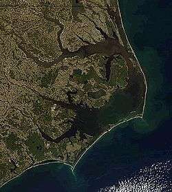
Cape Lookout is the southern point of the Core Banks, one of the natural barrier islands on the Atlantic coast of North Carolina, USA. It delimits Onslow Bay to the west from Raleigh Bay to the east. Core Banks and Shackleford Banks have been designated as parts of the Cape Lookout National Seashore.[1]
Cape Lookout is part of Carteret County and is located 11 miles southeast of Beaufort, NC. Cape Lookout is one of North Carolina's three major capes; the other two are Cape Hatteras to the north and Cape Fear to the south.
The Cape Lookout Lighthouse is located on the cape, approximately three miles northeast of the point of the cape.[2]
Hurricane Irene made landfall near the cape on Saturday, August 27, 2011 as a Category 1 storm with a very low pressure of 950 mbar.[3]
References
- ↑ Cape Lookout National Seashore. "Current Documents". Retrieved October 22, 2011.
- ↑ Cape Lookout National Seashore. "Maps". Retrieved October 22, 2011.
- ↑ "Irene makes landfall near Cape Lookout". Cape Fear Business News. August 27, 2011. Retrieved August 27, 2011. External link in
|publisher=(help)
Coordinates: 34°36′19″N 76°32′10″W / 34.60528°N 76.53611°W