Swan Islands, Honduras
|
Little Swan Island | |
| Geography | |
|---|---|
| Location | Caribbean Sea |
| Coordinates | 17°24′38″N 83°55′19″W / 17.41056°N 83.92194°WCoordinates: 17°24′38″N 83°55′19″W / 17.41056°N 83.92194°W |
| Archipelago | Bay Islands |
| Area | 3.1 km2 (1.2 sq mi) |
| Administration | |
|
Honduras | |
| Department | Bay Islands |
| Municipality | Islas de la Bahia |
| Demographics | |
| Population | 10 (2014) |
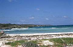
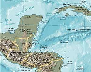
The Swan Islands, or Islas Santanilla or Islas del Cisne, is a chain of three islands located in the northwestern Caribbean Sea, approximately 95 miles (153 km) off the coastline of Honduras,[1] with a land area of 3.1 square kilometres (1.2 square miles).[2] The islands are inhabited by a small permanent Honduran navy garrison, located at Great Swan Island.
Geography
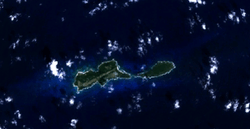
The Swan Islands lie within the exclusive economic zone of Honduras and belong to the Islas de la Bahía department of Honduras.[3] They consist of three islands:
- Great Swan Island (3 km long, 2 km²)
- Little Swan (2.4 km long, 0.5 km wide, 1.2 km²)
- Booby Cay (90 metres long, 70 m off the southwest corner of Great Swan, <0.01 km²)
Rosario Bank and Misteriosa Bank are 130 to 150 km (81–93 mi) north of the Swan Islands and separated from them by the >5,000 metres (16,404 feet) deep Cayman Trench.
The islands are uninhabited, except for a small Honduran navy garrison.[1] Great Swan has an airstrip, Islas del Cisne Airport.
History

At the turn of the century, Swan Island was set up as a U.S. Department of Agriculture animal quarantine station for the importation of beef. Also, the United Fruit Co. set up a wireless radio relay station for servicing their Caribbean fleet. During World War II, both the U.S. Navy and the U.S. Weather Bureau stationed personnel on the island. Later, the Federal Aviation Agency (FAA) and the (now named) National Weather Service (NWS) set up meteorological and communications assets on Swan in support of aeronautical services and hurricane prediction activities. The FAA departed Swan Island in the 1960s, leaving the NWS all assets and responsibilities. Both the United States and Honduras claimed the Swan Islands until the United States dropped its claim under the Guano Islands Act in 1972.[4] The ownership of the island has always been in dispute. The Sumner Smith family has always maintained their ownership and, apparently, did have some standing in the U.S. courts. Still, the U.S. elected to abandon its claim, in spite of this standing (ref. D S Platt, et al., NOAA-NWS). The islands gained attention in the early 1960s due to the activities of Radio Swan, that began broadcasting in May 1960 during preparation for, and during, the abortive Bay of Pigs Invasion of Cuba. The station was removed from the islands in the late 1960s and its main transmitter was transferred for use in the Vietnam War.
In 1965, a former Bellaire High School (Bellaire, Texas) student was questioned by police over his role in a teenage "army" dedicated to freeing "oppressed countries", the Houston Chronicle reported. The group, called the Kononiers, had been in existence for about five years, the student told the paper, and was armed through a series of burglaries of the Deep River Armory store. The weapons were taken to the Addicks Reservoir area, where they trained for combat. Their goal? The youths were training for "Operation Liberation Swan Island" off Honduras.[5]
In October 1998, Hurricane Mitch moved through the area with winds of 180 miles per hour (290 km/h).[6]
See also
- United States Miscellaneous Caribbean Islands
- List of Guano Island claims
- Honduras – United Kingdom Maritime Delimitation Treaty
References
- 1 2 Zuchora-Walske, Christine (1 August 2009). Honduras in Pictures. Twenty-First Century Books. p. 11. ISBN 978-1-57505-960-0.
- ↑ Due to a common mistake, the islands' size were measured by the Honduras Statistical Bureau in km2, but the typist accidentally typed sq miles, so the true 3.1 sq km size became recorded as 8 sq km. Google Earth photos support this.
- ↑ "Islas del Cisne". Glosk.com. Retrieved 15 January 2014.
- ↑ United States Treaties and Other International Agreements (in Spanish). Department of State. 1972. p. 2648.
- ↑ http://blog.chron.com/bayoucityhistory/2012/06/bellaire-senior-high-school
- ↑ Mariners weather log. United States National Weather Service, Environmental Data and Information Service. 1999. pp. 1–4.