Zólyom County
| Zólyom County Comitatus Zoliensis Zólyom vármegye Komitat Sohl Zvolenská župa | |||||
| County of the Kingdom of Hungary | |||||
| |||||
|
Coat of arms | |||||
 | |||||
| Capital | Besztercebánya 48°44′N 19°9′E / 48.733°N 19.150°ECoordinates: 48°44′N 19°9′E / 48.733°N 19.150°E | ||||
| History | |||||
| • | Established | 12th century | |||
| • | Treaty of Trianon | 4 June 1920 | |||
| Area | |||||
| • | 1910 | 2,634 km2 (1,017 sq mi) | |||
| Population | |||||
| • | 1910 | 133,700 | |||
| Density | 50.8 /km2 (131.5 /sq mi) | ||||
| Today part of | Slovakia | ||||
| Banská Bystrica is the current name of the capital. | |||||

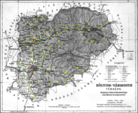
Zólyom county (in Latin: comitatus Zoliensis, in Hungarian Zólyom (vár)megye, in Slovak Zvolenský komitát/ Zvolenská stolica/ Zvolenská župa, in German Sohler Gespanschaft/Komitat Sohl) was an administrative county (comitatus) of the Kingdom of Hungary. Its territory is now in central Slovakia.
Geography
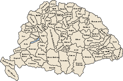
Zólyom county shared borders with the counties of Bars, Turóc, Liptó, Gömör-Kishont, Nógrád and Hont. The county's territory was situated along the central Garam river, approximately between (excluding) Korpona and (including) Breznóbánya. Its area was 2634 km² around 1910. The county was characterised by extensive mining activities.
Capitals
The capital of the county was the castle of Pusztavár near Zólyom, then from the late 15th century the Zvolen Castle (Hungarian: Zólyomi vár) and from the 1760s the town of Besztercebánya.
History
Zólyom county arose as a Hungarian comitatus in the 12th century, when most parts of the territory were conquered by the Kingdom of Hungary, from a huge royal property (the Vetusolium dominium). Initially, its territory included Árva, Turóc and Liptó, which became separate counties in the early 14th century.
In the aftermath of World War I, Zólyom county became part of newly formed Czechoslovakia, as recognized by the concerned states in 1920 by the Treaty of Trianon. The Zvolen county (Zvolenská župa) continued to exist until 1927, but it had completely different powers etc. and somewhat different borders. When Slovakia became independent temporarily between 1939 and 1945, the Hron county (Pohronská župa) was created in 1940, whose territory roughly corresponded to that of the Zvolen county. The capital was Banská Bystrica.
Together with the Slovak parts of Hont and Gemer, it became part of the Banská Bystrica Region (Banskobystrický kraj) created in 1948. In 1993, Czechoslovakia was split and the Zvolen county became part of Slovakia.
Demographics
1900
In 1900, the county had a population of 124,420 people and was composed of the following linguistic communities:[1]
Total:
- Slovak: 111,050 (89.3%)
- Hungarian: 9,078 (7.3%)
- German: 2,945 (2.3%)
- Croatian: 201 (0.2%)
- Romanian: 17 (0.0%)
- Ruthenian: 13 (0.0%)
- Serbian: 5 (0.0%)
- Other or unknown: 1,111 (0.9%)
According to the census of 1900, the county was composed of the following religious communities:[2]
Total:
- Roman Catholic: 80,194 (64.5%)
- Lutheran: 40,837 (32.8%)
- Jewish: 2,862 (2.3%)
- Calvinist: 327 (0.3%)
- Greek Catholic: 149 (0.1%)
- Greek Orthodox: 34 (0.0%)
- Unitarian: 3 (0.0%)
- Other or unknown: 14 (0.0%)
1910
In 1910, the county had a population of 133,653 people and was composed of the following linguistic communities:[3]
Total:
- Slovak: 113,294 (84.8%)
- Hungarian: 16,509 (12.4%)
- German: 2,124 (1.6%)
- Ruthenian: 136 (0.0%)
- Romanian: 26 (0.0%)
- Croatian: 14 (0.0%)
- Serbian: 13 (0.0%)
- Other or unknown: 1,537 (1.2%)
According to the census of 1910, the county was composed of the following religious communities:[4]
Total:
- Roman Catholic: 87,036 (65.1%)
- Lutheran: 42,405 (31.8%)
- Jewish: 3,080 (2.3%)
- Calvinist: 751 (0.6%)
- Greek Catholic: 317 (0.2%)
- Greek Orthodox: 60 (0.0%)
- Unitarian: 2 (0.0%)
- Other or unknown: 2 (0.0%)
Subdivisions
In the early 20th century, the subdivisions of Zólyom county were:
| Districts | |
|---|---|
| District | Capital |
| Besztercebánya | Besztercebánya, SK Banská Bystrica |
| Breznóbánya | Breznóbánya, SK Brezno |
| Nagyszalatna | Nagyszalatna, SK Zvolenská Slatina |
| Zólyom | Zólyom, SK Zvolen |
| Urban districts (rendezett tanácsú város) | |
| Besztercebánya, SK Banská Bystrica | |
| Breznóbánya, SK Brezno | |
| Zólyom, SK Zvolen | |
References
- ↑ "KlimoTheca :: Könyvtár". Kt.lib.pte.hu. Retrieved 2012-06-26.
- ↑ "KlimoTheca :: Könyvtár". Kt.lib.pte.hu. Retrieved 2012-06-26.
- ↑ "KlimoTheca :: Könyvtár". Kt.lib.pte.hu. Retrieved 2012-06-26.
- ↑ "KlimoTheca :: Könyvtár". Kt.lib.pte.hu. Retrieved 2012-06-26.