Syrmia County
| Syrmia County Srijemska ili Sremska županija Szerém vármegye Komitat Syrmien | |||||
| County of the Kingdom of Croatia-Slavonia, Kingdom of Hungary, Austria-Hungary (later Kingdom of Serbs, Croats and Slovenes) | |||||
| |||||
|
Coat of arms | |||||
 | |||||
| Capital | Vukovar 45°21′N 19°0′E / 45.350°N 19.000°ECoordinates: 45°21′N 19°0′E / 45.350°N 19.000°E | ||||
| History | |||||
| • | Established | 1745 | |||
| • | territorial reorganization of the SCS Kingdom | 1924[1] | |||
| Area | |||||
| • | 1910 | 6,866 km2 (2,651 sq mi) | |||
| Population | |||||
| • | 1910 | 414,234 | |||
| Density | 60.3 /km2 (156.3 /sq mi) | ||||
| Today part of | Croatia, Serbia | ||||

Syrmia County (Croatian: Srijemska županija; Serbian: Sremska županija/Сремска жупанија; Hungarian: Szerém vármegye; German: Komitat Syrmien) was a historic administrative subdivision (županija) of the Kingdom of Croatia-Slavonia, Kingdom of Hungary, Austria-Hungary. Croatia-Slavonia was an autonomous kingdom within the Lands of the Crown of Saint Stephen (Transleithania), the Hungarian part of the dual Austro-Hungarian Empire. The territory of the County is currently in eastern Croatia (smaller western part) and north-western Serbia (larger eastern part). The name Syrmia (Serbian: Srem, Croatian: Srijem) is still used for the corresponding regions in Croatia and Serbia. The capital of the county was Vukovar (Croatian, in Hungarian: Vukovár).
Geography
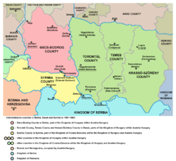
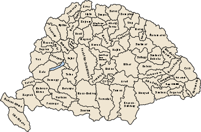
Syrmia County shared borders with other Croatian-Slavonian counties of Požega and Virovitica, the Austro-Hungarian land of Bosnia and Herzegovina, the Kingdom of Serbia, and the Hungarian counties of Bács-Bodrog and Torontál. The County stretched along the right (southern) bank of the river Danube and the left (northern) bank of the river Sava, down to their confluence. Its area was 6,866 km² around 1910.
Background
By the 13th century, two counties were formed in this region: Syrmia (in the east) and Vukovar (in the west). This area was taken by the Ottoman Empire in 1521 and the two counties were abolished. The territory was then (in 1544) included into Ottoman Sanjak of Syrmia. The Habsburg Empire took one part of Syrmia from the Ottomans in 1688, while the other part was taken by Habsburgs in 1718. The entire region was incorporated into the Military Frontier, which was then extended from Western Slavonia, where it stood in 1683, all the way to Transylvania.
History
Syrmia County was re-established in 1745. The county was included into the Kingdom of Slavonia, a Habsburg province, which was part of both, the Habsburg Kingdom of Croatia, and the Habsburg Kingdom of Hungary. The Kingdom of Slavonia was mainly inhabited by Serbs and Croats.
In 1848 and 1849, the area of the county was part of the Serbian Voivodship, a Serbian autonomous region proclaimed at the May Assembly in Karlovci. Between 1849 and 1860 the area was part of the Voivodeship of Serbia and Banat of Temeschwar, a separate crown land of the Austrian Empire. During this time the county did not existed since voivodeship was divided into districts.
After 1860, Syrmia County was established again, and was incorporated into the Kingdom of Slavonia, which was a completelly separate Habsburg province at the time. In 1867, as a consequence of the Ausgleich between the Austrians and the Hungarians, Kingdom of Slavonia was incorporated into Transleithania, the half of Austria-Hungary run from Budapest, and in the Hungarian-Croatian Settlement of 1868, it was incorporated into Croatia-Slavonia, a formally separate kingdom within the Kingdom of Hungary, which had a certain level of autonomy and was ruled by its own ban.
After World War I, the area of Syrmia County became part of the newly formed Kingdom of Serbs, Croats and Slovenes in 1918 and this was confirmed by the Treaty of Saint-Germain in September 1919.[2] The County of Syrmia was an official administrative division of the Kingdom of Serbs, Croats and Slovenes between 1918 and 1922 (de facto until 1924), and then was transformed into the Province (Oblast) of Syrmia. After 1924, the county as such no longer existed.
Demographics
- According to the census of 1870, the county had 120,352 inhabitants.
- According to the census of 1890, the county had 347,022 inhabitants.
In 1900, the county had a population of 381,739 people and was composed of the following linguistic communities:[3]
Total:
- Serbian: 168,982 (44.3%)
- Croatian: 100,360 (26.3%)
- German: 67,027 (17.6%)
- Hungarian: 23,539 (6.2%)
- Slovak: 11,415 (3.0%)
- Ruthenian: 4,345 (1.1%)
- Romanian: 601 (0.2%)
- Other or unknown: 5,470 (1.4%)
According to the census of 1900, the county was composed of the following religious communities:[4]
Total:
- Eastern Orthodox: 172,818 (45.3%)
- Roman Catholic: 171,142 (44.8%)
- Lutheran: 22,473 (5.9%)
- Calvinist: 5,750 (1.5%)
- Greek Catholic: 4,681 (1.2%)
- Jewish: 3,894 (1.0%)
- Unitarian: 2 (0.0%)
- Other or unknown: 979 (0.3%)

In 1910, the county had a population of 414,234 people and was composed of the following linguistic communities:[5]
Total:
- Serbian: 183,109 (44.2%)
- Croatian: 106,198 (25.6%)
- German: 68,086 (16.4%)
- Hungarian: 29,522 (7.1%)
- Slovak: 13,841 (3.3%)
- Ruthenian: 4,642 (1.1%)
- Romanian: 587 (0.1%)
- Other or unknown: 8,249 (2.0%)
According to the census of 1910, the county was composed of the following religious communities:[6]
Total:
- Eastern Orthodox: 189,007 (45.6%)
- Roman Catholic: 182,140 (44.0%)
- Lutheran: 25,927 (6.3%)
- Calvinist: 7,512 (1.8%)
- Greek Catholic: 5,722 (1.4%)
- Jewish: 3,779 (0.9%)
- Unitarian: 7 (0.0%)
- Other or unknown: 140 (0.0%)
Subdivisions

In the early 20th century, the subdivisions of Syrmia county were:
| Districts | |
|---|---|
| District | Capital |
| Irig | Irig |
| Mitrovica | Mitrovica, today Sremska Mitrovica |
| Ruma | Ruma |
| Stara Pazova | Stara Pazova |
| Šid | Šid |
| Ilok | Ilok |
| Vinkovci | Vinkovci |
| Vukovar | Vukovar |
| Zemun | Zemun |
| Županja | Županja |
| Urban counties | |
| Zemun | |
| Urban districts | |
| Sremski Karlovci | |
| Petrovaradin | |
| Mitrovica | |
The towns of Vukovar, Ilok, Vinkovci, and Županja are currently in Croatia, in Vukovar-Srijem county. The towns of Šid, Ruma, Irig, Mitrovica (Sremska Mitrovica), Stara Pazova, Sremski Karlovci and Petrovaradin are currently in Serbia (Vojvodina province). Zemun is currently in Serbian region of Belgrade.
See also
| Wikimedia Commons has media related to Syrmia County. |
Part of a series on the |
|---|
| History of Slavonia |
.png) |
|
Antiquity |
|
Habsburg Monarchy |
|
20th century |
References
- ↑ ARHiNET arhivski informacijski sistem
- ↑ Treaty of Saint-Germain (1919) - Britannica Online Encyclopedia
- ↑ "KlimoTheca :: Könyvtár". Kt.lib.pte.hu. Retrieved 2012-12-06.
- ↑ "KlimoTheca :: Könyvtár". Kt.lib.pte.hu. Retrieved 2012-12-06.
- ↑ "KlimoTheca :: Könyvtár". Kt.lib.pte.hu. Retrieved 2012-12-06.
- ↑ "KlimoTheca :: Könyvtár". Kt.lib.pte.hu. Retrieved 2012-12-06.