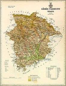
Gömör és Kishont County
| Gömör-Kishont County Comitatus Geomoriensis et Kishonthensis Gömör és Kishont vármegye Komitat Gemer und Kleinhont Gemersko-malohontská župa | |||||
| County of the Kingdom of Hungary | |||||
| |||||
|
Coat of arms | |||||
 | |||||
| {{#if:Rimaszombat| | Capital | Rimaszombat 48°23′N 20°1′E / 48.383°N 20.017°ECoordinates: 48°23′N 20°1′E / 48.383°N 20.017°E | |||
| History | |||||
| • | Established | 1786 | |||
| • | Treaty of Trianon | 4 June 1920 | |||
| Area | |||||
| • | 1910 | 4,279 km2 (1,652 sq mi) | |||
| Population | |||||
| • | 1910 | 188,100 | |||
| Density | 44 /km2 (113.9 /sq mi) | ||||
| Today part of | Slovakia, Hungary | ||||
| Rimavská Sobota is the current name of the capital. | |||||
Gömör-Kishont (Hungarian: Gömör és Kishont, Slovak: Gemer a Malohont, German: Gemer und Kleinhont) was an administrative county (comitatus) of the Kingdom of Hungary. Its capital was Rimaszombat (present-day Rimavská Sobota). Its territory is now in southern Slovakia and northern Hungary.
Geography
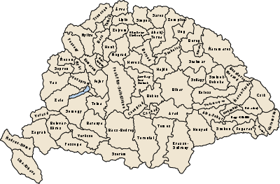
Around 1910, Gömör-Kishont county shared borders with the counties Zólyom, Liptó, Szepes, Abaúj-Torna, Borsod, Heves and Nógrád. It was situated in the Gömör–Szepesi-érchegység (present-day Slovak Ore Mountains - Slovenské rudohorie) approximately between the present-day Slovak-Hungarian border, the towns Poltár and Rozsnyó (present-day Rožňava) and the Low Tatras (Hungarian: Alacsony-Tátra, Slovak: Nízke Tatry). The river Sajó flowed through the county. Its area was 4,279 km² around 1910.
History
The county Gömör-Kishont was a combination of the counties Gömör and Kishont. It existed from 1786 until the end of World War I, with an interruption from 1790 until 1802. Gömör is one of the oldest counties of the Kingdom of Hungary, and was already mentioned in the 11th century. Kishont is the territory approximately between the towns Tiszolc (present-day Tisovec) and Rimaszombat (present-day Rimavská Sobota). Counties of Gömör and Kishont was part of Ottoman Empire between 1541–1595 and 1605–1687.
In the aftermath of World War I, most of Gömör-Kishont county became part of newly formed Czechoslovakia, as recognized by the concerned states in 1920 by the Treaty of Trianon. The area around Putnok became part of the Hungarian county Borsod-Gömör-Kishont (currently part of Borsod-Abaúj-Zemplén). The Czechoslovak part of the county was part of the Slovak Land (Slovenská krajina/zem).
Following the provisions of the First Vienna Award, most of the Czechoslovak part became part of Hungary again in November 1938. The Gömör-Kishont county was recreated. The small northernmost part that remained in Slovak hands (a.o. the towns Dobšiná and Revúca) became part of the new Hron county (Pohronská župa). The Trianon borders were restored after World War II. Since 1993, when Czechoslovakia was split, Gemer and Malohont have been part of Slovakia, and since 1996 divided between the Košice region and the Banská Bystrica region.
Demographics

In 1900, the county had a population of 183,784 people and was composed of the following linguistic communities:[1]
Total:
- Hungarian: 103,660 (56.4%)
- Slovak: 74,517 (40.6%)
- German: 4,059 (2.2%)
- Croatian: 37 (0.0%)
- Romanian: 20 (0.0%)
- Ruthenian: 10 (0.0%)
- Serbian: 1 (0.0%)
- Other or unknown: 1,480 (0.8%)
According to the census of 1900, the county was composed of the following religious communities:[2]
Total:
- Roman Catholic: 79,838 (43.4%)
- Lutheran: 59,459 (32.4%)
- Calvinist: 34,707 (18.9%)
- Jewish: 5,339 (2.9%)
- Greek Catholic: 4,344 (2.4%)
- Greek Orthodox: 84 (0.0%)
- Unitarian: 9 (0.0%)
- Other or unknown: 4 (0.0%)
Subdivisions
In the early 20th century, the subdivisions of Gömör-Kishont county were:
| Districts (járás) | |
|---|---|
| District | Capital |
| Feled | Feled, SK Jesenské |
| Garamvölgy | Nándorvölgy, SK Vaľkovňa |
| Nagyrőce | Jolsva, SK Jelšava |
| Putnok | Putnok |
| Ratkó | Ratkó, SK Ratková |
| Rimaszombat | Nyustya, SK Hnúšťa |
| Rozsnyó | Rozsnyó, SK Rožňava |
| Tornalja | Tornalja, SK Tornaľa |
| Urban districts (rendezett tanácsú város) | |
| Dobsina, SK Dobšiná | |
| Jolsva, SK Jelšava | |
| Nagyrőce, SK Revúca | |
| Rimaszombat, SK Rimavská Sobota | |
| Rozsnyó, SK Rožňava | |
Putnok is now in Hungary; all other named towns are now in Slovakia.
References
- ↑ "KlimoTheca :: Könyvtár". Kt.lib.pte.hu. Retrieved 2012-12-06.
- ↑ "KlimoTheca :: Könyvtár". Kt.lib.pte.hu. Retrieved 2012-12-06.