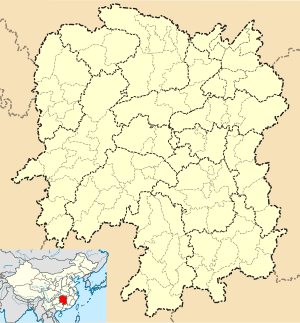
Zhijiang Dong Autonomous County
| Zhijiang Dong Autonomous County 芷江侗族自治县 | |
|---|---|
| County | |
|
| |
 Zhijiang Location in Hunan | |
| Coordinates: 27°26′42″N 109°41′06″E / 27.445°N 109.685°ECoordinates: 27°26′42″N 109°41′06″E / 27.445°N 109.685°E[1] | |
| Country | People's Republic of China |
| Province | Hunan |
| Prefecture-level city | Huaihua |
| Area[2] | |
| • Total | 2,095.53 km2 (809.09 sq mi) |
| Population (2010)[3] | |
| • Total | 339,437 |
| • Density | 160/km2 (420/sq mi) |
| Time zone | China Standard (UTC+8) |
| Postal code | 4191XX |
| Area code(s) | 0745 |
| Zhijiang | |||||||||
| Chinese | 芷江 | ||||||||
|---|---|---|---|---|---|---|---|---|---|
| Postal | Chihkiang | ||||||||
| |||||||||
| Zhijiang Dong Autonomous County | |||||||||
| Traditional Chinese | 芷江侗族自治縣 | ||||||||
|---|---|---|---|---|---|---|---|---|---|
| Simplified Chinese | 芷江侗族自治县 | ||||||||
| Postal | Chihkiang Tung Autonomous County | ||||||||
| |||||||||
Zhijiang Dong Autonomous County (simplified Chinese: 芷江侗族自治县; traditional Chinese: 芷江侗族自治縣; pinyin: Zhǐjiāng Dòngzú Zìzhìxiàn) is under the administration of Huaihua, Hunan province, China, bordering Guizhou to the west. On 21 August 1945 Japan officially surrendered to China near the airfield in Zhijiang. The Japanese Vice General Secretary signed the surrounding treaty, marking the end of the Second Sino-Japanese War.
Geography
Zhijiang County is situated in western Hunan at the eastern end of the Yunnan-Guizhou Plateau, amongst the southern end of the Xuefeng and Wuling Mountains. It borders Xinhuang Dong Autonomous County and Guizhou's Wanshan District and Tianzhu County to the west, Huitong County and Hongjiang Administrative District to the south, Zhongfang County and Hecheng District to the east, and Mayang Miao Autonomous County to the north.
Zhijiang County has a humid subtropical climate (Köppen Cfa), with an annual mean temperature of 16.53 °C (61.8 °F). Winters are mild and brief, beginning somewhat dry and turning wet and gloomy as the season progresses. Spring is very rainy, especially in May, which is the wettest month. Summer is hot and humid (but tempered compared to much of the province), with moderate levels of rain, and generous sunshine; on average, July and August are the only two months where the area receives more than half of possible sunshine. Autumn is the driest season. From March to June, on average, more than half of the days each month receive some precipitation. The monthly 24-hour average temperature ranges from 4.9 °C (40.8 °F) in January to 27.2 °C (81.0 °F) in July. The annual precipitation is around 1,230 mm (48 in). With monthly percent possible sunshine ranging from 15% in February to 56% in August, the county receives 1,482 hours of sunshine annually.
| Climate data for Zhijiang County (1971−2000) | |||||||||||||
|---|---|---|---|---|---|---|---|---|---|---|---|---|---|
| Month | Jan | Feb | Mar | Apr | May | Jun | Jul | Aug | Sep | Oct | Nov | Dec | Year |
| Average high °C (°F) | 8.6 (47.5) |
10.2 (50.4) |
14.7 (58.5) |
21.4 (70.5) |
25.9 (78.6) |
28.9 (84) |
32.0 (89.6) |
32.3 (90.1) |
28.2 (82.8) |
22.6 (72.7) |
17.1 (62.8) |
11.8 (53.2) |
21.1 (70.1) |
| Average low °C (°F) | 2.3 (36.1) |
4.0 (39.2) |
7.5 (45.5) |
13.1 (55.6) |
17.4 (63.3) |
21.2 (70.2) |
23.3 (73.9) |
23.0 (73.4) |
19.2 (66.6) |
14.1 (57.4) |
9.0 (48.2) |
4.2 (39.6) |
13.2 (55.7) |
| Average precipitation mm (inches) | 45.7 (1.799) |
49.9 (1.965) |
77.5 (3.051) |
150.0 (5.906) |
202.2 (7.961) |
209.0 (8.228) |
130.7 (5.146) |
110.5 (4.35) |
69.7 (2.744) |
102.5 (4.035) |
53.7 (2.114) |
28.7 (1.13) |
1,230.1 (48.429) |
| Average precipitation days (≥ 0.1 mm) | 13.4 | 13.0 | 16.4 | 18.0 | 16.7 | 15.4 | 11.2 | 10.4 | 9.0 | 12.6 | 9.7 | 9.0 | 154.8 |
| Average relative humidity (%) | 80 | 79 | 81 | 82 | 82 | 84 | 80 | 79 | 78 | 80 | 79 | 77 | 80.1 |
| Mean monthly sunshine hours | 53.9 | 48.3 | 60.6 | 98.2 | 130.5 | 145.4 | 232.9 | 228.8 | 170.0 | 126.8 | 102.6 | 84.0 | 1,482 |
| Percent possible sunshine | 16 | 15 | 16 | 26 | 32 | 35 | 55 | 56 | 46 | 36 | 32 | 26 | 33 |
| Source: China Meteorological Administration | |||||||||||||
References
- www.xzqh.org (Chinese)
- ↑ Google (2014-07-02). "Zhijiang" (Map). Google Maps. Google. Retrieved 2014-07-02.
- ↑ Huaihua City Land Use Plan (2006–20)/《怀化市土地利用总体规划(2006-2020年)》.(Chinese) Accessed 8 July 2014.
- ↑ "怀化市2010年第六次全国人口普查主要数据公报" (in Chinese). Huaihua Statistical Bureau/怀化市统计局. Archived from the original on July 14, 2014. Retrieved 9 July 2014.