Yowie Bay, New South Wales
| Yowie Bay Sydney, New South Wales | |||||||||||||
|---|---|---|---|---|---|---|---|---|---|---|---|---|---|
 Yowie Bay marina | |||||||||||||
| Coordinates | 34°02′59″S 151°06′12″E / 34.04977°S 151.10334°ECoordinates: 34°02′59″S 151°06′12″E / 34.04977°S 151.10334°E | ||||||||||||
| Population | 3,167 (2011 census)[1] | ||||||||||||
| Established | 1889 | ||||||||||||
| Postcode(s) | 2228 | ||||||||||||
| Location | 24 km (15 mi) south of Sydney CBD | ||||||||||||
| LGA(s) | Sutherland Shire | ||||||||||||
| State electorate(s) | Cronulla, Miranda | ||||||||||||
| Federal Division(s) | Cook | ||||||||||||
| |||||||||||||
Yowie Bay is a suburb in southern Sydney, in the state of New South Wales, Australia. Yowie Bay is located 24 kilometres south of the Sydney central business district, in the local government area of the Sutherland Shire.
Yowie Bay takes its name from the small bay on the north shore of the Port Hacking estuary (also known locally as the Port Hacking River). It is bounded to the north by the suburb of Miranda and shares its postcode of 2228. Located to the east, across the Yowie Bay waterway, is Caringbah South. To the west is the suburb of Gymea Bay, across the bay of the same name.
History
Yowie is an Aboriginal name meaning 'place of echoes'. There appears to be no relationship to the mythical Australian creature called a Yowie.[2]
Land in the area was originally released as the Village of 'Weerona' in 1889. The name 'Ewey Bay' was also recognised by the electoral office and post office in the early days.[3] It has been suggested that the name is a corruption of ewes (female sheep). Yowie Bay was named by Surveyor Dixon in 1827. The suburb was officially assigned the name in 1973 by the Geographical Names Board.[4]
 Yowie Bay homes and jetties
 Yowie Bay view towards Port Hacking
Commercial area
Yowie Bay is a mostly residential area with just a few scattered commercial developments. A marina is located at the end of Wonga Road with a liquor shop nearby. The Port Hacking Open Sailing Club sits on Yowie Bay. The Postbox Café is on the corner of Forest Road and Attunga Road, occupying the former site of a corner shop. The Yowie Bay Friendly Grocer (formerly Yowie Bay General Store) is located on Forest Road. There is one small school, Yowie Bay Public School.
 Yowie Bay marina
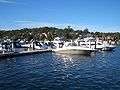 Yowie Bay marina
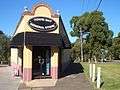 Yowie Bay general store
References
- ↑ Australian Bureau of Statistics (31 October 2012). "Yowie Bay (State Suburb)". 2011 Census QuickStats. Retrieved 20 April 2015.
- ↑ Sutherland Shire place names Archived 18 September 2006 at the Wayback Machine.
- ↑ "Post office for Ewey Bay". The Sydney Morning Herald. 18 March 1910. p. 6. Retrieved 21 April 2015.
- ↑ The Book of Sydney Suburbs, Compiled by Frances Pollon, Angus & Robertson Publishers, 1990, Published in Australia ISBN 0-207-14495-8, page 277
External links
| Wikimedia Commons has media related to Yowie Bay, New South Wales. |