Yarrowee River
| Yarrowee | |
| River[1] | |
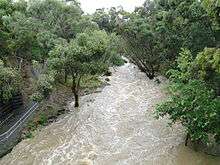
 View of the Yarrowee River between Black Hill and East Ballarat west toward Peel Street. The Ballarat railway station clock tower is visible in the distance | |
Name origin:
| |
| Nickname: Yarrowee Creek | |
| Country | Australia |
|---|---|
| State | Victoria |
| Region | Central Highlands |
| Part of | Corangamite catchment |
| Tributaries | |
| - left | Warrenheip Creek, Little Bendigo Creek, Canadian Creek, Redan Creek |
| - right | Gnarr Creek, Winter Creek, Ross Creek (Victoria) |
| City | Ballarat |
| Source | Gong Gong Creek |
| - location | Gong Gong |
| - elevation | 520 m (1,706 ft) |
| Mouth | Leigh River |
| - location | Cambrian Hill, Victoria |
| - elevation | 377 m (1,237 ft) |
| - coordinates | 37°37′48″S 143°49′54″E / 37.63000°S 143.83167°ECoordinates: 37°37′48″S 143°49′54″E / 37.63000°S 143.83167°E |
| Length | 43 km (26.7 mi) |
| [1][4] | |
The Yarrowee River is a perennial river of the Corangamite catchment, located in the Central Highlands region of the Australian state of Victoria.
Location and features
The Yarrowee is a major tributary and catchment of the Barwon River. The river's origins are in the hills at Gong Gong, and it is notable for passing through the settlement of Ballarat and crossing the City of Ballarat local government area before becoming the Leigh River in the vicinity of Cambrian Hill and Golden Plains Shire.[5]
The river is a secondary water supply for the city of Ballarat. Its catchment contains several tributaries in the urban area including Gnarr Creek, Gong Gong Creek, Little Bendigo Creek and Warrenheip in the north eastern reaches and; Redan Creek, Canadian Creek and Buninyong Creek in the southern reaches.[6] The river flows through the Ballarat suburbs of Gong Gong, Nerrina, Brown Hill, Black Hill, Ballarat East, Ballarat Central, Golden Point, Redan, Mount Pleasant, Sebastopol, Mount Clear, Magpie and Cambrian Hill. Tributaries in the catchment run through most other Ballarat suburbs and the river also marks the border between several suburbs.
It is a seasonal watercourse with highly varying levels of flow, often swelling in the winter months and prone to flash flooding, though it is not unusual for its flow (and that of its tributaries) to at times stop altogether.
History and toponomy
Prior to the European settlement of Australia, the river was an important place for the Boro gundidj, a tribe of the Wathaurong Indigenous Australian people as they based themselves around its northern stretches.[7]
The river was important to the first settlers (squatters) of the region, with William Cross Yuille establishing his home near the swamp that is now Lake Wendouree, that was an important part of the river's catchment. The Ballarat gold rush brought dramatic changes to the river. It was used as a source of water for extensive placer mining. The first bridge, a crude wooden structure, was built in 1855 at the present site of Bridge Road in response to increasing coach traffic.[8]
Indigenous inhabitants were driven away from the river by the increasing rush of new settlers. During the 1860s, much of the river and its tributaries were sealed as drains using quarried bluestone to prevent erosion and help mitigate frequent flooding. The river was known to flood in the early days. In 1869 a serious flood of the Yarrowee River put most of the lower section of the city including Bridge and Grenville Street underwater and causing the loss of two lives.[9] In 1877 the Gong Gong reservoir was built to alleviate flooding and to Lake Wendouree as the primary water source for Ballarat. By the turn of the century, the river had become heavily polluted during the early industrialisation of Ballarat.
During the 1960s, the river through the Ballarat CBD was re-routed, concreted and built over. As a result, it now forms an underground drain running under Grenville Street. Many other parts of the river also became wide and deep concrete stormwater drains. Several stretches of the river, remain, however in its natural bush and parkland setting. Since the 1980s, major initiatives have been undertaken to restore the river's state and vegetation and several natural wetlands have also been re-established along the river's course.[10] The river suffered flash flooding during the 2010 and the 2011 Victorian floods. A Victorian Government–funded A$1 million clean up of the river over three years was announced in July 2013; yet by May 2014 problems of sewage contamination remained a problem near Ballarat.[11][12]
Etymology
It is believed that the name Yarrowee was derived from Yaramlok, the name given to the river by the Wathaurung people.[2][3] According to historian Jennifer Barnes [13] the aboriginal word means "gum tree growing in water". Barnes also suggests that aborigines called the river 'Nambrook'. She cites historian Weston Bate who claimed that the aboriginal word was 'Yar-ar-way' and Arthur Jenkins who claims it was 'Yarmlock'. Barnes also suggests miners had referred to it as the 'Wee Yarrow'.[13] The latter gives rise to alternative theories including a derivation of Yarrow Water, Scotland, attributed to the early Scottish settlers of the area.
Communities and bridge crossings along the river
There are many crossings over the Yarrowee River, including road, rail and pedestrian. Some additional roads allow passage through shallow sections of the river when the water levels are low.
| Location | Bridge name | Comments/use | Image |
|---|---|---|---|
| Brown Hill | Daylesford-Ballarat Road | ||
| Hillview Road | |||
| Springs Road | |||
| Western Freeway | |||
| Brown Hill Hotel (pedestrian) | |||
| Ried Crt (Brown Hill Oval) (pedestrian) | |||
| Ainley Street, Brown Hill | |||
| Nerrina | Stawell Street Nth | ||
| Ballarat East / Ballarat Central | Oliver Street | ||
| Queen Street Nth (pedestrian) | |||
| Newman Street (pedestrian) | |||
| Princes Street, Black Hill | |||
| Nicholas Street, Black Hill | |||
| Peel Street, Black Hill | |||
| Eastern Oval (pedestrian) | |||
| Scott Parade | |||
| Serviceton railway line | |||
| Grenville Street | |||
| Grant Street | |||
| Mt Pleasant | Hill Street | ||
| Redan | Prest Street | ||
| Sebastopol | Whitehorse Road bridge; built of concrete and steel in the 1920s; destroyed when central pole collapsed during January 2011 floods; rebuilt October 2011.[14] | ||
| Docwra Street | |||
| Magpie | Midland Highway |
References
| Wikimedia Commons has media related to Yarrowee River. |
- 1 2 "Yarrowee River: 9029". Vicnames. Government of Victoria. 2 May 1966. Retrieved 1 June 2014.
- 1 2 "Sebastapol". Ballarat Koori Heritage Trail. Ballarat and District Aboriginal Co-operative Limited. Archived from the original on 23 April 2011. Retrieved 1 July 2014.
- 1 2 "Yarrowee River: Historical Information". Vicname. Government of Victoria. 5 May 2011. Retrieved 1 June 2014.
- ↑ "Map of Yarrowee River, VIC". Bonzle Digital Atlas of Australia. Retrieved 1 June 2014.
- ↑ Leigh River sediment sourcing and transport Corangamite Catchment Management Authority
- ↑ "Yarrowee River Sub-catchment Master Plans" (PDF). Yarrowee River Plan and the Leigh Catchment Strategy (PDF). City of Ballarat. April 2003. Retrieved 1 June 2014.
- ↑ "Ballarat's Indigenous Heritage" (PDF). Sovereign Hill Education. Retrieved 19 August 2010.
- ↑ pg 8. The Sydney Morning Herald. 6 July 1855
- ↑ "The Great Flood of Ballarat". The Maitland Mercury & Hunter River General Advertiser. 23 October 1869. p. 6.
- ↑ Quinlan, Kim (11 April 2002). "Yarrowee: Don't call it a creek". The Courier.
- ↑ Choahan, Neelima (17 July 2013). "Ballarat's Yarrowee River: $1 million for clean-up". The Courier. Retrieved 1 June 2014.
- ↑ Jaens, David (29 May 2014). "Yarrowee River cleaned after sewage contamination". The Courier. Retrieved 1 June 2014.
- 1 2 Ballarat Historical Society Newsletter. Vol.5 No.3. May/June 2003
- ↑ "Community Magazine". City of Ballarat. July 2011: 12.
External links
- "Yarrowee River Sub-catchment Master Plans" (PDF). Yarrowee River Plan and the Leigh Catchment Strategy (PDF). City of Ballarat. April 2003.
- "Corangamite Catchment Management Authority". Government of Victoria. 2014.
Rivers of the Corangamite catchment, Victoria, Australia | |
|---|---|
| |
|