Golden Plains Shire
| Golden Plains Shire Victoria | |||||||||||||
|---|---|---|---|---|---|---|---|---|---|---|---|---|---|
 Typical scenery of the Golden Plains Shire. | |||||||||||||
 | |||||||||||||
| Population | 20,809 (2015 est)[1] | ||||||||||||
| • Density | 7.6956/km2 (19.932/sq mi) | ||||||||||||
| Established | 1994 | ||||||||||||
| Gazetted | 6 May 1994[2] | ||||||||||||
| Area | 2,704 km2 (1,044.0 sq mi) | ||||||||||||
| Mayor | Cr Jenny Blake | ||||||||||||
| Council seat | Bannockburn | ||||||||||||
| Region | Western Victoria | ||||||||||||
| State electorate(s) | |||||||||||||
| Federal Division(s) | |||||||||||||
 | |||||||||||||
| Website | Golden Plains Shire | ||||||||||||
| |||||||||||||
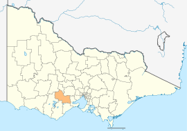
The Golden Plains Shire is a local government area in Victoria, Australia, located in the western part of the state. It covers an area of 2,704 square kilometres (1,044 sq mi) and, at the 2011 Census, had a population of 18,770.[3] It includes the towns of Bannockburn, Gheringhap, Lethbridge, Linton, Berringa, Teesdale, Rokewood and Meredith. It was formed in 1994 from the amalgamation of the Shire of Bannockburn, Shire of Leigh, Shire of Grenville and part of the Shire of Buninyong. When formed the municipality was originally called the Southern Rural Shire, but a few months later, was renamed to its current name.[2]
The Shire is governed and administered by the Golden Plains Shire Council; its seat of local government and administrative centre is located at the Council headquarters in Bannockburn, it also has a service centre located in Linton.
Council
Current composition
The council is composed of seven councillors elected to represent an unsubdivided municipality.[4]
| Ward | Councillor | Notes | |
|---|---|---|---|
| Unsubdivided | Jenny Blake | Mayor (2013–14) | |
| Andrew Cameron | |||
| Nathan Hansford | |||
| Helena Kirby | |||
| Bill McArthur | |||
| Des Phelan | |||
| Greg Vaughan | |||
Administration and governance
The council meets in the council chambers at the council headquarters in the Bannockburn Municipal Offices, which is also the location of the council's administrative activities. It also provides customer services at both its administrative centre in Bannockburn, and its service centre in Linton.
Localities
Localities which encompass the Golden Plains Shire include:
- Anakie
(shared with Greater Geelong) - Bamganie
- Bannockburn
- Barunah Park
- Batesford
(shared with Greater Geelong) - Berringa
- Berrybank
(shared with Corangamite) - Cambrian Hill
- Cape Clear
- Corindhap
- Cressy
(shared with Corangamite and
Colac Otway) - Dereel
- Durdidwarrah
- Durham Lead
(shared with Ballarat) - Enfield
- Garibaldi
- Gheringhap
- Grenville
(shared with Moorabool) - Haddon
- Happy Valley
- Hesse
- Illabarook
- Inverleigh
(shared with Surf Coast) - Lethbridge
- Linton
(shared with Pyrenees) - Mannibadar
- Maude
- Meredith
(shared with Moorabool) - Mount Bute
(shared with Corangamite) - Mount Mercer
- Morrisons
(shared with Moorabool) - Murgheboluc
- Napoleons
- Newtown
- Nintingbool
- Piggoreet
- Pitfield
- Pittong
(shared with Corangamite and Pyrenees) - Rokewood
- Rokewood Junction
- Ross Creek
- Russells Bridge
- Scarsdale
- Shelford
- She Oaks
- Smythes Creek
(shared with Ballarat) - Smythesdale
(shared with Pyrenees) - Springdallah
- Staffordshire Reef
- Steiglitz
- Stonehaven
- Sutherlands Creek
- Teesdale
- Wallinduc
- Werneth
(shared with Corangamite) - Willowvale
- Wingeel
(shared with Colac Otway)
References
- ↑ "3218.0 – Regional Population Growth, Australia, 2014–15". Australian Bureau of Statistics. Retrieved 29 September 2016.
- 1 2 Victoria Government Gazette – Online Archive (1837–1997). "Order establishing (Part 3) the Southern Rural Shire". State Library of Victoria. State Government of Victoria (published 6 May 1994). p. 1. Retrieved 10 January 2014.
- ↑ Census QuickStats (2011). "Golden Plains (S) – LGA22490". Australian Bureau of Statistics. Government of Australia. Retrieved 10 January 2014.
- ↑ Local Government in Victoria. "Golden Plains Shire Council". Department of Transport, Planning and Local Infrastructure. State Government of Victoria. Retrieved 10 January 2014.
External links
- Golden Plains Shire Council official website
- Metlink local public transport map
- Link to Land Victoria interactive maps
Coordinates: 38°01′00″S 143°58′00″E / 38.01667°S 143.96667°E