Werribee River
| Werribee (Wirribi-yaluk[1]) | |
| River[2] | |
 Werribee River at Exford, downstream from Melton Reservoir | |
| Name origin: Aboriginal (Boonwurrung/Wathawurrung): wirribi meaning "backbone".[1][3] | |
| Country | Australia |
|---|---|
| State | Victoria |
| Regions | Victorian Midlands (IBRA), Western District, Port Phillip |
| Local government areas | Moorabool, Melton, Wyndham |
| Part of | Port Phillip catchment |
| Tributaries | |
| - left | Lerderderg River, Toolern Creek |
| Cities | Ballan, Bacchus Marsh, Werribee |
| Source | Great Dividing Range |
| - location | Wombat State Forest near Korweinguboora |
| - elevation | 501 m (1,644 ft) |
| - coordinates | 37°26′S 144°10′E / 37.433°S 144.167°E |
| Mouth | Port Phillip |
| - location | near Werribee South |
| - elevation | 9 m (30 ft) |
| - coordinates | 37°58′42″S 144°41′40″E / 37.97833°S 144.69444°ECoordinates: 37°58′42″S 144°41′40″E / 37.97833°S 144.69444°E |
| Length | 110 km (68 mi) |
| National park | Werribee Gorge State Park |
| Reservoir | Melton Reservoir |
| Wikimedia Commons: Werribee River | |
| [2][4] | |
The Werribee River is a perennial river of the Port Phillip catchment that is located on the plain west of Melbourne, Victoria, Australia. The headwaters of a tributary, the Lerderderg River, are north of Ballan near Daylesford and it flows across the basalt plain, through the suburb of Werribee to enter Port Phillip. A linear park follows the Werribee River along much of its course. In total the Werribee River completes a journey of approximately 110 kilometres (68 mi).[5]
The river flows through the Werribee Gorge State Park before being utilised for irrigation of market gardens at Bacchus Marsh, then through Werribee where it is crossed by the Maltby By-pass. It then flows through the Werribee Open Range Zoo in Werribee Park, and finally the small coastal settlement of Werribee South before entering Port Phillip. The Western Treatment Plant, a sewage treatment site, is located near the mouth of the river, and supplies irrigation needs to the zoo.
The Werribee River Trail winds beside the Werribee River from Davis Creek in Tarneit to the Princes Highway in Werribee.
History
Before the arrival of white settlers, the Werribee River was the boundary of the Bunurong tribe whose six clans lived along the Victorian coast across the Mornington Peninsula, Western Port Bay to Wilsons Promontory.
In the late 1830s and 1840s the Werribee River was the scene of conflicts between the Wautharong people and the European colonisers. The squatter Charles Franks and a shepherd were speared to death near Mount Cottrell in July 1836. This resulted in a punitive party led by John Batman which came upon a large party of aborigines and indiscriminately shot and killed at least ten. There are accounts of arsenic laced flour being given to local aborigines.
In 1851 a substantial timber bridge was built to cross the Werribee River to replace an earlier wooden bridge. In 1852 this bridge was washed away when the Werribee river flooded.
In August 2004 the Victorian Government pledged $300,000 towards restoring the Werribee River, removing willows choking the river around the township and replacing them with native plants in a habitat restoration project.
Etymology
The explorers Hume and Hovell camped by the river on 15 December 1824 and named it the Arndell after Hovell's father-in-law. John Helder Wedge 're-discovered' the river in 1835 and initially called it the Peel, but then decided to call it the Ex or Exe. Exford, an early crossing place on the river, is derived from this name.[3] One of the local Wautharong speaking Kulin tribesman that accompanied Wedge said the name for the stream was 'Weariby Yallock' ('yallock' meaning 'stream'). The spelling changed to the present form of Werribee, and the original aboriginal word meant spine or backbone.[1]
Fishing
Werribee river holds fish all along its course, most of which are at the mouth of the river in to Port Phillip Bay in the Estuary. This area is best fished for Southern Black Bream.
Highlights/Features
K-road Cliffs is probably the most unusual feature of the river, this is behind the Werribee golf course, sometimes described as looking like a river in Arnhem Land in the NT. A photo of the K-road Cliffs on the Werribee River
Things to do
Exploring the river offers an array of outdoor opportunities and is indeed a favorite pastime for many local residents. An extensive network of hard surface bike and walking trails along the river showcase the plethora of native flora and fauna that inhabit the river and its banks.
There are many fishing spots along the river and canoe/boat launching facilities are located at the Werribee South Boat Ramp and Riverbend Historical Park.
Bird watching is also a popular activity however care must be taken as there are known to be Eastern Brown Snakes and other deadly fauna inhabiting the area.
See also
Gallery
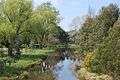 Running through parkland in Ballan
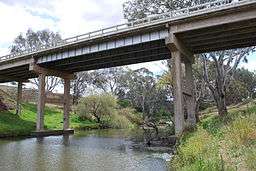
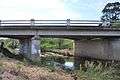 Under the old Western Highway at Ballan
 A ford across the river west of Bacchus Marsh
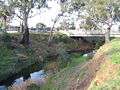 Marking the boundary between Bacchus Marsh and Maddingley
 In flood over Cotrell Street in Werribee
References
- 1 2 3 "Werribee River: 29151: Traditional Name: Wirribi-yaluk". Vicnames. Government of Victoria. 12 August 2011. Retrieved 7 April 2014.
- 1 2 "Werribee River: 29151". Vicnames. Government of Victoria. 2 May 1966. Retrieved 7 April 2014.
- 1 2 Reed, A. W. (1973). Place names of Australia (1st ed.). Frenchs Forest: Reed Books. p. 224. ISBN 0-589-50128-3.
- ↑ "Map of Werribee River, VIC". Bonzle Digital Atlas of Australia. Retrieved 7 April 2014.
- ↑ "Werribee River". City of Wyndham.
External links
Waterways of the Greater Melbourne catchment, Victoria, Australia | |
|---|---|
| Ocean inlets, harbours and bays | |
| Rivers | |
| Creeks |
|
| Lagoons and lakes | |
| Adjoining rivers and bays | |
| |
| Port Phillip sub-catchment |
|
|---|---|
| Western Port sub-catchment | |
| |