Lerderderg River
| Lerderderg | |
| River[1] | |
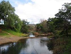 Lerderderg River, near Darley | |
| Nickname: The Lerdy[2] | |
| Country | Australia |
|---|---|
| State | Victoria |
| Regions | Victorian Midlands (IBRA), Western District |
| Local government area | Moorabool |
| Part of | Port Phillip catchment |
| Tributaries | |
| - left | The Old River, Goodman Creek |
| Town | Bacchus Marsh |
| Landmark | Lerderderg Gorge |
| Source | Blackwood Ranges, Great Dividing Range |
| - location | Lerderderg State Forest |
| - elevation | 474 m (1,555 ft) |
| - coordinates | 37°29′37″S 144°21′36″E / 37.49361°S 144.36000°E |
| Mouth | confluence with the Werribee River |
| - location | within the Melton Reservoir |
| - elevation | 91 m (299 ft) |
| - coordinates | 37°42′27″S 144°31′08″E / 37.70750°S 144.51889°ECoordinates: 37°42′27″S 144°31′08″E / 37.70750°S 144.51889°E |
| Length | 40 km (25 mi) |
| National park | Lerderderg State Park |
| Reservoir | Melton Reservoir |
| Wikimedia Commons: Lerderderg River | |
| [1][3] | |
The Lerderderg River (known locally as The Lerdy[2]) is a perennial river of the Port Phillip catchment, located in the Western District region of the Australian state of Victoria.
Location and features
The Lerderderg River rises below the Blackwood Ranges, part of the Great Dividing Range, in the Lerderderg State Forest, near the locality of Blackwood. The river flows generally south by east in a highly meandering course, joined by two minor tributaries, before reaching its confluence with the Werribee River within the Melton Reservoir, southeast of Bacchus Marsh. The river descends approximately 383 metres (1,257 ft) over its 40 kilometres (25 mi) course.[3]
A diversion in the river's course, called the Lerderderg River diversion tunnel, located approximately 25 kilometres (16 mi) upriver from Bacchus Marsh, was constructed between 1855 and 1870. The tunnel was driven through a mountain spur in a horseshoe bend, diverting the river, and allowing the exposed river bed to be sluiced for alluvial gold.[4][5]
The river is known for the Lerderderg Gorge Picnic Ground, camping, bushwalking, and fishing. In earlier days, gold was mined in the upper reaches, and some of the old mines (considered dangerous to enter) can be seen as you travel along the sluice on the east bank, which previously fed into those mines. The water has slowed down to a trickle for the past few years because of a severe drought, but there are still a few popular swimming spots along the river, including "Harry's Hole", "Third Hole", and "The Pit", all of which are in the Lerderderg Gorge.
The river is traversed by the Western Freeway northeast of Bacchus Marsh.[3]
See also
References
- 1 2 "Lerderderg River: 19449". Vicnames. Government of Victoria. 2 May 1966. Retrieved 7 April 2014.
- 1 2 "At long last the Lerdy flows again". Issues and campaigns: Water catchment. Wombat Forestcare Inc. 2010. Retrieved 7 April 2014.
- 1 2 3 "Map of Lerderderg River, VIC". Bonzle Digital Atlas of Australia. Retrieved 7 April 2014.
- ↑ "Lerderderg State Park Visitor Guide" (PDF). Park Notes. Parks Victoria. December 2010. Retrieved 27 November 2011.
- ↑ "Historic Gold Mining Sites in the South West Region of Victoria, Report on Cultural Heritage". Victorian Goldfields Project. Department of Natural Resources and Environment. August 1999. Archived from the original (PDF) on 8 March 2011.
Waterways of the Greater Melbourne catchment, Victoria, Australia | |
|---|---|
| Ocean inlets, harbours and bays | |
| Rivers | |
| Creeks |
|
| Lagoons and lakes | |
| Adjoining rivers and bays | |
| |
| Port Phillip sub-catchment |
|
|---|---|
| Western Port sub-catchment | |
| |