Xinghe County
| Xinghe County 兴和县 • ᠰᠢᠩᠾᠧᠰᠢᠶᠠᠨ | |
|---|---|
| County | |
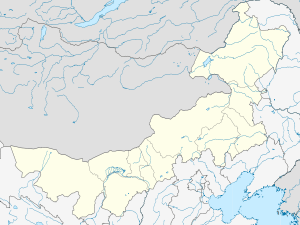 Xinghe Location in Inner Mongolia | |
| Coordinates: 40°52′N 113°50′E / 40.867°N 113.833°E | |
| Country | People's Republic of China |
| Region | Inner Mongolia |
| Prefecture-level city | Ulaan Chab |
| Elevation | 1,279 m (4,196 ft) |
| Time zone | China Standard (UTC+8) |
Xinghe County (Mongolian: ᠰᠢᠩᠾᠧ ᠰᠢᠶᠠᠨ Siŋhė siyan, Шинхэ шянь; simplified Chinese: 兴和县; traditional Chinese: 興和縣; pinyin: Xīnghé Xiàn) is a county of south-central Inner Mongolia, People's Republic of China, bordering the provinces of Hebei to the east and Shanxi to the south. It is under the administration of Ulaan Chab City, and is situated on the China National Highway 110 between Ulaan Chab and Zhangjiakou in Hebei province. Bordering county-level divisions include Fengzhen City to the southwest, Chahar Right Front Banner to the west, Chahar Right Back Banner to the northwest, and Shangdu County to the north.
References
- www.xzqh.org (Chinese)
This article is issued from Wikipedia - version of the 5/27/2016. The text is available under the Creative Commons Attribution/Share Alike but additional terms may apply for the media files.