Morin Dawa Daur Autonomous Banner
| Morin'dawa Banner 莫力达瓦旗 • Morin'dawaa guasei ᠮᠣᠷᠢᠨᠳᠠᠪᠠᠭᠠᠬᠣᠰᠢᠭᠤ | |
|---|---|
| Autonomous banner | |
| Morin'dawa Daur Autonomous Banner 莫力达瓦达斡尔族自治旗 ᠮᠣᠷᠢᠨᠳᠠᠪᠠᠭᠠᠳᠠᠭᠤᠷᠥᠪᠡᠷᠲᠡᠭᠡᠨᠵᠠᠰᠠᠬᠤᠬᠣᠰᠢᠭᠤ Morin'dawaa Daor weerie ixkiewu guasei | |
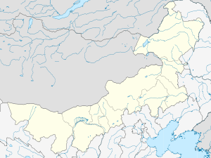 Morin Dawa Location in Inner Mongolia | |
| Coordinates: 48°28′N 124°30′E / 48.467°N 124.500°ECoordinates: 48°28′N 124°30′E / 48.467°N 124.500°E | |
| Country | People's Republic of China |
| Region | Inner Mongolia |
| Prefecture-level city | Hulunbuir |
| Elevation | 228 m (748 ft) |
| Time zone | China Standard (UTC+8) |
Morin Dawa Daur Autonomous Banner (Mongolian: ᠮᠣᠷᠢᠨ ᠳᠠᠪᠠᠭᠠ ᠳᠠᠭᠤᠷ ᠥᠪᠡᠷᠲᠡᠭᠡᠨ ᠵᠠᠰᠠᠬᠤ ᠬᠣᠰᠢᠭᠤ Морин Даба-а Даур өбэртэгэн жасақу қосиу Morin Dabaɣ-a Daɣur öbertegen jasaqu qosiɣu; Daur: Morin Dawaa Daor weerie ixkiewu guasei; simplified Chinese: 莫力达瓦达斡尔族自治旗; traditional Chinese: 莫力達瓦達斡爾族自治旗; pinyin: Mòlì Dáwǎ Dáwò'ěrzú Zìzhìqí) is one of three autonomous banners in Inner Mongolia, People's Republic of China, created for the Daur people. It lies on the Nen River, borders Heilongjiang province to the east, south, and southwest, and is under the administration of Hulunbuir City.
References
- www.xzqh.org (Chinese)
This article is issued from Wikipedia - version of the 5/27/2016. The text is available under the Creative Commons Attribution/Share Alike but additional terms may apply for the media files.